Big Hill is a hill just East of Montpelier in Idaho. It was known to be one of the steepest descents along the Oregon Trail. [1] [2] One can still see wagon ruts going up and over the hill from the roadside turnout. [3]
It is sign #338 at Milepost 441.7 along the Idaho Highway Historical Marker Route. [4] A collection of over 244 signs created as part of the Idaho Centennial celebration. It is also part of the Human Migration Monument project. [5]

The Oregon Trail was a 2,170-mile (3,490 km) east–west, large-wheeled wagon route and emigrant trail in the United States that connected the Missouri River to valleys in Oregon. The eastern part of the Oregon Trail spanned part of what is now the state of Kansas and nearly all of what are now the states of Nebraska and Wyoming. The western half of the trail spanned most of the current states of Idaho and Oregon.

Hells Canyon is a ten-mile-wide (16 km) canyon in the western United States, located along the border of eastern Oregon, a small section of eastern Washington and western Idaho. It is part of the Hells Canyon National Recreation Area which is also located in part of the Wallowa-Whitman National Forest. It is North America's deepest river gorge at 7,993 feet (2,436 m). Notably, Hells Canyon runs deeper than the better-known Grand Canyon in Arizona.
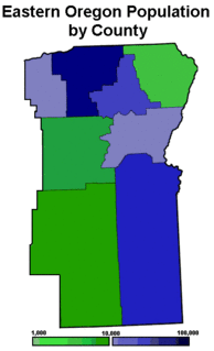
Eastern Oregon is the eastern part of the U.S. state of Oregon. It is not an officially recognized geographic entity; thus, the boundaries of the region vary according to context. It is sometimes understood to include only the eight easternmost counties in the state; in other contexts, it includes the entire area east of the Cascade Range. Cities in the basic eight-county definition include Baker City, Burns, Hermiston, Pendleton, John Day, La Grande, and Ontario. Umatilla County is home to the largest population base in Eastern Oregon; accounting for 42% of the region's residents. Hermiston, located in Umatilla County, is the largest city in the region, accounting for 10% of Eastern Oregon's residents. Major industries include transportation/warehousing, timber, agriculture and tourism. The main transportation corridors are I-84, U.S. Route 395, U.S. Route 97, U.S. Route 26, U.S. Route 30, and U.S. Route 20.
U.S. Route 2 or U.S. Highway 2 (US 2) is an east–west U.S. Highway spanning 2,571 miles (4,138 km) across the northern continental United States. US 2 consists of two segments connected by various roadways in southern Canada. Unlike some routes, which are disconnected into segments because of encroaching Interstate Highways, the two portions of US 2 were designed to be separate in the original 1926 highway plan.

Blue Star Memorial Highways are highways in the United States that are marked to pay tribute to the U.S. armed forces. The National Council of State Garden Clubs, now known as National Garden Clubs, Inc., started the program in 1945 after World War II. The blue star was used on service flags to denote a service member fighting in the war. The program has since been expanded to include Memorial Markers and Memorial By-ways. These markers are used in National Cemeteries, parks, veterans facilities, and gardens.

U.S. Route 89 is a north–south United States Numbered Highway with two sections, and one former section. The southern section runs for 848 miles (1,365 km) from Flagstaff, Arizona, to the southern entrance of Yellowstone National Park. The northern section runs for 404 miles (650 km) from the northern entrance of Yellowstone National Park in Montana, ending at the Canadian border. Unnumbered roads through Yellowstone connect the two sections. Before 1992, US 89 was a Canada–Mexico, border-to-border highway that ended at Nogales, Arizona, on its southern end.

The Jefferson Davis Highway, also known as the Jefferson Davis Memorial Highway, was a planned transcontinental highway in the United States in the 1910s and 1920s that began in Arlington, Virginia, and extended south and west to San Diego, California; it was named for Jefferson Davis, President of the Confederate States, United States senator, and Secretary of War. Because of unintended conflict between the National Auto Trail movement and the federal government, it is unclear whether it ever really existed in the complete form that its United Daughters of the Confederacy (UDC) founders originally intended.
A commemorative plaque, or simply plaque, or in other places referred to as a historical marker or historic plaque, is a plate of metal, ceramic, stone, wood, or other material, typically attached to a wall, stone, or other vertical surface, and bearing text or an image in relief, or both, to commemorate one or more persons, an event, a former use of the place, or some other thing. Many modern plaques and markers are used to associate the location where the plaque or marker is installed with the person, event, or item commemorated as a place worthy of visit. A monumental plaque or tablet commemorating a deceased person or persons, can be a simple form of church monument. Most modern plaques affixed in this way are commemorative of something, but this is not always the case, and there are purely religious plaques, or those signifying ownership or affiliation of some sort. A plaquette is a small plaque, but in English, unlike many European languages, the term is not typically used for outdoor plaques fixed to walls.

The Barlow Road is a historic road in what is now the U.S. state of Oregon. It was built in 1846 by Sam Barlow and Philip Foster, with authorization of the Provisional Legislature of Oregon, and served as the last overland segment of the Oregon Trail. Its construction allowed covered wagons to cross the Cascade Range and reach the Willamette Valley, which had previously been nearly impossible. Even so, it was by far the most harrowing 100 miles (160 km) of the nearly 2,000-mile (3,200 km) Oregon Trail.
Interstate 90 (I-90) is a transcontinental Interstate Highway that runs east–west across the northern United States. Within the state of Idaho, the freeway travels for 74 miles (119 km) from the Washington border near Spokane to Coeur d'Alene and the panhandle region at the north end of the state. After traveling through the Silver Valley along the Coeur d'Alene River in the Bitterroot Range, I-90 crosses into Montana at Lookout Pass.
Interstate 84 (I-84) in the U.S. state of Oregon is a major Interstate Highway that traverses the state from west to east. It is concurrent with U.S. Route 30 (US 30) for most of its length and runs 376 miles (605 km) from an interchange with I-5 in Portland to the Idaho state line near Ontario. The highway roughly follows the Columbia River and historic Oregon Trail in northeastern Oregon, and is designated as part of Columbia River Highway No. 2 and all of the Old Oregon Trail Highway No. 6; the entire length is also designated as the Vietnam Veterans Memorial Highway. I-84 intersects several of the state's main north–south roads, including US 97, US 197, I-82, and US 395.

U.S. Route 26 is a major cross-state United States highway with its western terminus in the U.S. state of Oregon, connecting U.S. Route 101 on the Oregon Coast near Seaside with the Idaho state line east of Nyssa. Local highway names include the Sunset Highway No. 47, Mount Hood Highway No. 26, and John Day Highway No. 5 before continuing into Idaho and beyond.

Erratic Rock State Natural Site is a state park in the Willamette Valley of Oregon, United States. Featuring a 40-short-ton (36 t) glacial erratic from the Missoula Floods, the small park sits atop a foothill of the Northern Oregon Coast Range in Yamhill County between Sheridan and McMinnville off Oregon Route 18. The day use only park is owned and maintained by the Oregon Parks and Recreation Department.
In the U.S. state of Idaho, U.S. Route 95 (US-95) is a north–south highway near the western border of the state, stretching from Oregon to British Columbia for over 538 miles (866 km); it was earlier known in the state as the North and South Highway.
The Overland Trail was a stagecoach and wagon trail in the American West during the 19th century. While portions of the route had been used by explorers and trappers since the 1820s, the Overland Trail was most heavily used in the 1860s as a route alternative to the Oregon, California, and Mormon trails through central Wyoming. The Overland Trail was famously used by the Overland Stage Company owned by Ben Holladay to run mail and passengers to Salt Lake City, Utah, via stagecoaches in the early 1860s. Starting from Atchison, Kansas, the trail descended into Colorado before looping back up to southern Wyoming and rejoining the Oregon Trail at Fort Bridger. The stage line operated until 1869 when the completion of the First Transcontinental Railroad eliminated the need for mail service via stagecoach.
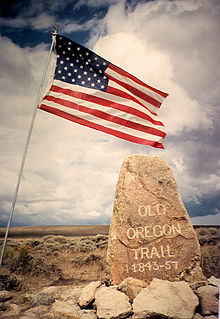
The historic 2,170-mile (3,490 km) Oregon Trail connected various towns along the Missouri River to Oregon's Willamette Valley. It was used during the 19th century by Great Plains pioneers who were seeking fertile land in the West and North.

Elijah Bristow (1788–1872) was the first white settler to stake a claim and build a permanent cabin in 1846 in the upper Willamette Valley, in what is now Lane County, Oregon, United States. He and his wife Susannah Gabbert Bristow established the first church and donated land for the first school in Pleasant Hill.
| | This Idaho location article is a stub. You can help Wikipedia by expanding it. |
| | This Bear Lake County, Idaho state location article is a stub. You can help Wikipedia by expanding it. |