
The Blackstone Canal was a manmade waterway, linking Worcester, Massachusetts, to Providence, Rhode Island, and Narragansett Bay, through the Blackstone Valley, via a series of locks and canals in the early 19th century. Construction started in 1825, and the canal opened three years later. After the opening of the Boston and Providence Railroad (1835), the canal struggled for business. Its transportation role was taken over by the Providence and Worcester Railroad, which completed a parallel line in 1847. The canal shut down in 1848. Several segments of the canal are preserved, and the canal alignment and remains are on the National Register of Historic Places.

The Water Shops Armory, located at 1 Allen Street, was a part of the Springfield Armory in Springfield, Massachusetts. Developed beginning in 1857, it served as the heavy manufacturing complex for the armory. It was listed on the National Register of Historic Places in 1980.

The Hayward Mill is a historic mill complex at the junction of North and Cook Streets, on the Mumford River in Douglas, Massachusetts. The site, with an industrial history dating to the 18th century, is populated by a series of connected buildings dating to 1880 or later. The mill was the first financial successful textile operation in Douglas, and was operated until the 1960s. The mill complex was listed on the National Register of Historic Places in 1991. It has been converted to residential use.
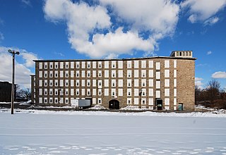
Flint Mills is a historic textile mill complex located on Alden Street in Fall River, Massachusetts, near the banks of the Quequechan River. The company was founded in 1872 and named in honor of John D. Flint, who served as its first president. The original 1872 mill burned in 1882, and was rebuilt in 1883. The complex was later expanded with a second mill and large addition in 1909. The site also contains a detached granite mill office building. The section of Fall River surrounding the mill became known as "Flint Village". The site was added to the National Register of Historic Places in 1983.

The Falmouth Pumping Station is a historic water pumping station on Pumping Station Road in Falmouth, Massachusetts. The complex consists of an 1898 Queen Anne pumping station designed by Ernest N. Boyden, a low-lift pump and water treatment building built in 1993, a chlorination tank also built in 1993, and a house and garage added in 1932. The plant was built in response to rising demand for vacation properties and fire suppression, and continues to fulfill those functions today. The complex was listed on the National Register of Historic Places in 1998.

The Glendale Power House is a historic power station on the Housatonic River, just off Massachusetts Route 183 in Stockbridge, Massachusetts. The 1905 power house, built for the Monument Mills, was one of the first places in the United States where electricity was generated for the purpose of providing power to an industrial facility. The station was listed on the National Register of Historic Places in 1982. The facility has been rehabilitated and converted into modernized hydroelectric power generation plant.

Essex Company Machine Shop, also known as Stone Mill or the Lawrence Machine Shop, is a historic machine shop on Union Street in Lawrence, Massachusetts. It was built in 1846 and added to the National Register of Historic Places in 1972.

The Great Stone Dam was built between 1845 and 1848 on the site of Bodwell's Falls on the Merrimack River in what became Lawrence, Massachusetts. The dam has a length of 900 feet (270 m) and a height of 35 feet (11 m).

The North Canal Historic District of Lawrence, Massachusetts, encompasses the historic industrial heart of the city. It is centered on the North Canal and the Great Stone Dam, which provided the waterpower for its many mill complexes. The canal was listed on the National Register of Historic Places in 1975, while the district was first listed in 1984, and then expanded slightly in 2009.

Ascutney Mill Dam, also known as the Windsor Upper Dam and the Mill Pond Dam, is an arch-gravity dam which is one of the oldest and among the earliest storage dams in the United States. It is made of cut granite and is located in Windsor, Vermont in Windsor County near the Connecticut River, where it functioned as a source of hydropower and, later, hydroelectric power. It is on the ASCE list of historic civil engineering landmarks since 1970 and is listed on the National Register of Historic Places since January 09, 2007.
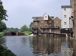
Coxes Lock is towards the northern end of the Wey Navigation parallel to the River Wey in Addlestone, Surrey,

The Schuyler Mill, also known as the Ford Soybean Plant Complex, is an old mill site that Henry Ford turned into one of his small village industry factories. It is located at 555-600 Michigan Avenue in Saline, Michigan, and was listed on the National Register of Historic Places in 1996.

The Nashua Manufacturing Company Historic District in Nashua, New Hampshire, is a historic district that was listed on the National Register of Historic Places (NRHP) in 1987. It encompasses an area just west of downtown Nashua, roughly located along the southern bank of the Nashua River, bordered on the west side by Mine Falls Park, on the south side by the Nashua River canal, up to Ledge Street, and from the east side by Factory, Pine and Water streets, up to the Main Street bridge.

The West Chesterfield Historic District is a historic district that encompasses the 19th century industrial and residential heritage of the village of West Chesterfield in the town of Chesterfield, Massachusetts. Centered at the junction of Main Road and Ireland Street, it was one of the town's main industrial sites for many years. The district was listed on the National Register of Historic Places in 2008.
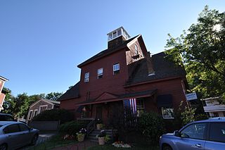
The Ashland Gristmill and Dam are a historic former industrial facility in the heart of Ashland, New Hampshire. Built in 1903 on the site of an older mill, the gristmill demonstrates the continuing viability of wood framing for mill buildings in an era when it had become uncommon. The property was listed on the National Register of Historic Places in 1979. It has been converted to professional offices.

The Cocheco Mills comprise a historic mill complex in the heart of Dover, New Hampshire. The mills occupy a bend in the Cochecho River that has been site of cotton textile manufacturing since at least 1823, when the Dover Manufacturing Company supplanted earlier sawmills and gristmills. The present mill buildings were built between the 1880s and the early 20th century, and were listed on the National Register of Historic Places in 2014.

The Newichawannock Canal is a man-made canal which drains Great East Lake into Horn Pond at the border between Wakefield, New Hampshire, and Acton, Maine, in the northeastern United States. It is at the head of the Salmon Falls River, which the Abenaki called Newichawannock, meaning "river with many falls". Begun in 1850 by the Great Falls Company to increase the water available for its mills in Somersworth, New Hampshire, the 0.75-mile (1.21 km) canal is unusual as it was built for strictly industrial purposes in an area remote from the actual industrial site. The canal forms the boundary between the states of New Hampshire and Maine, and is spanned by a stone bridge built at the same time. The canal and bridge, along with related artifacts, were listed on the National Register of Historic Places in 2014.
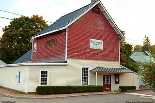
The Dexter Grist Mill, now the Dexter Historical Society Museum, is a historic 19th-century industrial property in Dexter, Maine. Built in 1854, the mill was operated by a single family for over a century, and was converted to a museum in 1967. It was listed on the National Register of Historic Places in 1975.

The Lermond Mill, now also known as Morgan's Mill, is a historic mill complex on Payson Road in Union, Maine. With a history dating to the late 18th century, and its present buildings from the early 19th century, it is one of the oldest operational water-powered mills in the state of Maine. It was listed on the National Register of Historic Places in 1984. As of 2006, it was reported to be in use for power generation and as a grist mill.
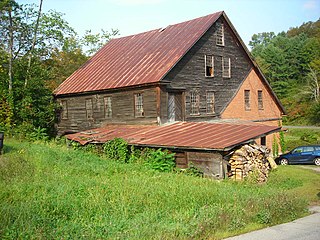
The Hayward and Kibby Mill, also known as the Tunbridge Mill, is a historic industrial facility on Spring Road in Tunbridge, Vermont. It includes a substantially complete water-powered 19th-century grist mill dating back to 1820, with a later sawmill added about 1870. It is one of the few surviving water-powered mills in the state, and is believed to be the only one featuring both a sawmill and grist (grain) mill. It was listed on the National Register of Historic Places in 1992.


