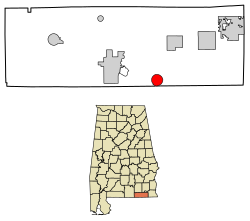
Black, Alabama | |
---|---|
Coordinates: 31°0′40″N85°44′39″W / 31.01111°N 85.74417°W | |
Country | United States |
State | Alabama |
County | Geneva |
Government | |
• Mayor | Lisa Brown |
Area | |
• Total | 4.06 sq mi (10.52 km2) |
• Land | 4.05 sq mi (10.50 km2) |
• Water | 0.01 sq mi (0.02 km2) |
Elevation | 226 ft (69 m) |
Population (2020) | |
• Total | 221 |
• Density | 54.51/sq mi (21.05/km2) |
Time zone | UTC-6 (Central (CST)) |
• Summer (DST) | UTC-5 (CDT) |
ZIP code | 36314 |
Area code | 334 |
FIPS code | 01-07120 |
GNIS feature ID | 0114392 |
Black is a town in Geneva County, Alabama, United States. It incorporated in 1905. It is part of the Dothan, Alabama Metropolitan Statistical Area. At the 2020 census, the population was 221, an increase over the figure of 207 tabulated in 2010.
Black is located at 31°0′40″N85°44′40″W / 31.01111°N 85.74444°W (31.011112, -85.744365). [2]
According to the U.S. Census Bureau, the town has a total area of 3.1 square miles (8.0 km2), all land.
Census | Pop. | Note | %± |
---|---|---|---|
1910 | 485 | — | |
1920 | 614 | 26.6% | |
1930 | 335 | −45.4% | |
1940 | 348 | 3.9% | |
1950 | 239 | −31.3% | |
1960 | 133 | −44.4% | |
1970 | 171 | 28.6% | |
1980 | 156 | −8.8% | |
1990 | 174 | 11.5% | |
2000 | 202 | 16.1% | |
2010 | 207 | 2.5% | |
2020 | 221 | 6.8% | |
U.S. Decennial Census [3] 2013 Estimate [4] |
As of the census [5] of 2000, there were 202 people, 85 households, and 57 families residing in the town. The population density was 65.6 inhabitants per square mile (25.3/km2). There were 102 housing units at an average density of 33.1 per square mile (12.8/km2). The racial makeup of the town was 94.06% Caucasian, 5.45% African American, and 0.50% Native American.
There were 85 households, out of which 29.4% had children under the age of 18 living with them, 52.9% were married couples living together, 9.4% had a female householder with no husband present, and 31.8% were non-families. 28.2% of all households were made up of individuals, and 16.5% had someone living alone who was 65 years of age or older. The average household size was 2.38 and the average family size was 2.93.
In the town, the population was spread out, with 23.8% under the age of 18, 11.4% from 18 to 24, 24.8% from 25 to 44, 22.3% from 45 to 64, and 17.8% who were 65 years of age or older. The median age was 39 years. For every 100 females, there were 72.6 males. For every 100 females age 18 and over, there were 79.1 males.
The median income for a household in the town was $31,250, and the median income for a family was $36,250. Males had a median income of $27,857 versus $15,924 for females. The per capita income for the town was $12,628. About 13.2% of families and 19.2% of the population were below the poverty line, including 32.4% of those under the age of eighteen and 8.0% of those 65 or over.
New Brockton is a town in Coffee County, Alabama, United States. At the 2020 census, the population was 1,428. The community was named for Huey E. Brock, a settler who came to the region in 1871.
Napier Field is a town in Dale County, Alabama. At the 2020 census, the population was 409. It is part of the Ozark micropolitan statistical area. The town was originally constructed as a military air base during the Second World War. It is currently adjacent to Dothan Regional Airport. While the airport itself lies within Dothan's city limits, the adjacent housing units and other buildings constitute the incorporated town of Napier Field.
Coffee Springs is a town in Geneva County, Alabama, United States. It was incorporated in 1900, and it is considered to be a part of the Dothan, Alabama Metropolitan Statistical Area. At the 2010 census the population was 228, down from 251.
Webb is a town in Houston County, Alabama, United States. It is named for plantation owner B. F. Webb, who settled in the area around 1890. The town was incorporated in 1903. It is part of the Dothan, Alabama Metropolitan Statistical Area. As of the 2010 census, the population was 1,430, up from 1,298 in 2000.
Shorter is a town in Macon County, Alabama, United States. At the 2020 census the population was 385, down from 474 at the 2010 census. According to the 1990 U.S. Census records, it was incorporated in 1984.
Greensboro is a town in Gadsden County, Florida, United States. The Town of Greensboro is part of the Tallahassee Metropolitan Statistical Area. The population was 461 at the 2020 US census, down from 602 at the 2010 US census.
Archer is a city in O'Brien County, Iowa, United States. The population was 117 at the 2020 census.
Upton is a town in Oxford County, Maine, United States. The population was 69 at the 2020 census.
Casco Township is a civil township of St. Clair County in the U.S. state of Michigan. As of the 2020 Census, the township population was 3,990.
Bigfork is a city in Itasca County, Minnesota, United States. The population was 400 at the 2020 census. Scenic State Park is nearby.
Agency is a village in Buchanan County, Missouri, United States. The population was 671 at the 2020 census. It is part of the St. Joseph, MO–KS Metropolitan Statistical Area.
Brooklyn is a city in Cuyahoga County, Ohio, United States. The population was 11,359 at the 2020 census. A suburb of Cleveland, it is a part of the Cleveland metropolitan area.
Chest Township is a township in Clearfield County, Pennsylvania, United States. The population was 510 at the 2020 census.
Beaver Springs is a census-designated place in Spring Township, Snyder County, Pennsylvania, United States. The population was 634 at the 2000 census.
Great Bend is a borough in Susquehanna County, Pennsylvania, United States, 39 miles (63 km) north of Scranton. According to 2020 Census data, Great Bend's population was 634, down 13.6% from 2010. Great Bend sits along the Susquehanna River, less than two miles from the New York State border, and is located directly off Interstate 81. Several small manufacturers also call Great Bend home. Great Bend is considered a bedroom community of the Binghamton, NY metropolitan area. Downtown Binghamton is roughly 11 miles (18 km) from Great Bend. The borough has three public parks. Billy Greenwood Memorial Park on Kilrow Avenue and Veterans' Memorial Park on Spring St. overlook the Susquehanna River. Great Bend is within the Blue Ridge School District.
Henderson is an unincorporated community and former town in Mason County, West Virginia, United States, at the confluence of the Ohio and Kanawha Rivers. The population was 231 at the 2020 census. It is part of the Point Pleasant, WV–OH Micropolitan Statistical Area. The town was incorporated in 1893 and named for Samuel Bruce Henderson, who owned the townsite at the time. The town was unincorporated following a public hearing on August 11, 2022.
Reedy is a town in Roane County, West Virginia, United States. The population was 152 at the 2020 census.
Camden-on-Gauley is a town in Webster County, West Virginia, United States, along the Gauley River. The population was 126 at the 2020 census.
Fence is a town in Florence County, Wisconsin, United States. The population was 231 at the 2000 census. The origin of the name "Fence" is obscure.
Winter is a village in Sawyer County, Wisconsin, United States. The population was 233 at the 2010 census. The village is within the Town of Winter.