Boldmere

Last updated

Boldmere
Boldmere Road houses - geograph.org.uk - 974870.jpg
Boldmere Road
West Midlands UK location map.svg
Red pog.svg
Boldmere
Location within the West Midlands
OS grid reference SP109940
Metropolitan borough
Metropolitan county
Region
Country England
Sovereign state United Kingdom
Post town SUTTON COLDFIELD
Postcode district B73
Dialling code 0121
Police West Midlands
Fire West Midlands
Ambulance West Midlands
UK Parliament
List of places
UK
England
West Midlands
52°32′N1°50′W / 52.54°N 1.83°W / 52.54; -1.83

Boldmere is a suburb and residential area of Sutton Coldfield, City of Birmingham, England. It is bordered by New Oscott, Sutton Park, Wylde Green and Erdington, and is in the ward of Sutton Vesey. [1]

Contents

History

Toponymy

"Boldmere" is a corruption of the word "Baldmoor", coming from the Middle English bald (meaning "a white patch") and the Anglo-Saxon moor (meaning "boggy land"). Therefore, Boldmere literally means a "bald moor"; a treeless patch. Bald (meaning "bold") was also a personal name used by the Anglo-Saxons. [2]

Name history

At the time of John Speed's 1610 atlas The Theatre of the Empire of Great Britaine , Boldmere was known as Cofield Wast. [3] The area was described as "an open, wild and windy expanse, covered with gorse". [4]

The United Kingdom Census of 1841 refers to the area as Baldmoor Lake, which was once a body of water south of the Chester Road. The lake has also been known as Bowen Pool, Baldmoor, and Bolemore Lake, [2] though no lake is shown on Speed's map of 1610 (nor on other later maps). The census did, however, list a dwelling on the Chester Road as "Lake House". [3] There is, however, a Lakehouse Road and Baldmoor Lake Road in the area. [5] [6]

By 1856, the area had become known as The Coldfield, a name which lasted at least until the introduction of the railway. [7]

Expansion

On introduction of the 1825 Inclosure Act, the area saw little expansion due to common land becoming privately owned. [3] The 1841 census listed eight families in the area, including agricultural workers, a painter, an Irish carrier, and a wire drawer. [2] It is likely that the latter worked at Penns Mill, [2] a nearby wire mill run by the Webster family (with Baron Dickinson Webster's business involvements including the transatlantic telegraph cable).

Boldmere did expand, however, upon the introduction of the London and North Western Railway. Two stations opened in the region at Wylde Green and Chester Road, in 1862 and 1863 respectively. [8] [9]

A second housing boom occurred in the 1930s, with both private and council housing being built.

Administration

In 1857, Boldmere was designated as an ecclesiastical parish, formed from the parish of St Michael's in Sutton Coldfield. [10] When Sutton Coldfield was reorganised in 1885 (under the Municipal Corporations Act 1882), Boldmere was created as a ward, before being divided into Boldmere West and Boldmere East in 1935. [10]

Boldmere is now part of the Royal Sutton Coldfield Town Council, [11] which was formed following a consultative ballot in 2015. The role of this organisation is the same as a parish council. Boldmere is in the Sutton Vesey electoral ward. [1]

Geography

Boldmere Gate, providing access to Sutton Park on the north boundary of Boldmere BoldmereGate.jpg
Boldmere Gate, providing access to Sutton Park on the north boundary of Boldmere

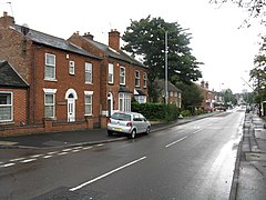
Boldmere is triangular in shape and roughly bounded on the north by Sutton Park, on the east by the Cross-City railway line and on the south-west by Chester Road. Boldmere Gate provides access to Sutton Park.

The main shopping centre of Boldmere is at the northern end of Boldmere Road, which runs north-south through the centre of Boldmere. The collection of shops at the southern end of Boldmere Road is known locally as Little Boldmere. [2]

Gibbet Hill, in the north-west of the area, is named after the gibbet from which Edward Allport was hanged for the murder of London silk dyer John Johnson in the area on 28 March 1729. [7] Although this site is no longer referred to as Gibbet Hill, and was undeveloped until (at least) 1906, [7] the toponymy has survived in the name of Gibbet Hill Wood; an area which Birmingham City Council have identified as "an area of potential archaeological importance" due to "surviving archaeological remains". [12]

Location in context

Economy

Boldmere is well-served with shops, hairdressers, pubs and restaurants. There are also a post office [13] and a public library. [14] All banks in Boldmere have now closed with the nearest branches being in Erdington or Sutton Town Centre.

Industry

A view of the north-east end of Powells Pool - the slipway is visible in the foreground Powell's Pool, Boldmere.jpg
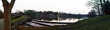
A view of the north-east end of Powells Pool – the slipway is visible in the foreground

In the 18th century, Powell's Pool (then known as New Forge Pool) near Boldmere Gate was the site of the mill used by John Wyatt to experiment with mechanised cotton spinning. [2] Along with Lewis Paul, he developed the roller spinning machine and the flyer-and-bobbin system (Paul patented the former on 24 June 1738). In 1750, the mill was used by William Powell to manufacture spades (using locally-grown ash wood for the handles). It is believed that the first steel garden fork was manufactured at the mill. [2] The building was later used to produce steel for the production of pen nibs. [2] The Ordnance Survey's First Series map (1834) identifies a forge in this area, [15] of which John Willets (a forgeman), John Page (a spade maker), and John Harris (a saw maker) have all been identified as proprietors. [7]

The mill was demolished some time after 1936, after lying unused and dilapidated for a number of years. Although none of the building's structure remains, a waterfall (providing a spillway to Powell's Pool) is now sited where the millrace was located. [2]

Transport

Boldmere's main roads are Jockey Road (A453), Chester Road (A452) and Boldmere Road (B4142). Boldmere is served by Wylde Green and Chester Road railway stations, both on the Cross-City railway line, which runs between Lichfield Trent Valley and Redditch (via Birmingham New Street).

Boldmere is served by a number of National Express West Midlands bus services, including routes 5, 66, 77 and 907.

Places of worship

St Michael's Church StMichaelsBoldmere.jpg
St Michael's Church

The churches in the area are St Michael's (Church of England), [16] St Nicholas's (Roman Catholic), [17] Chester Road Baptist Church, [18] Boldmere Methodist Church, [19] and Wylde Green United Reformed Church. [20] St Nicholas's Church was preceded by a chapel that was designed by Augustus Welby Northmore Pugin and which opened in 1841. [21] These churches take their name from Cardinal Nicholas Wiseman. [21]

The ring of bells at St Michael's church are noted as being one of the few rings in Birmingham still in existence that were produced before the introduction of scientific bell tuning in the 1890s (John Taylor & Co installed Birmingham's first harmonic ring at St. Barnabas' Church, Erdington in 1906). The bells' 18th–19th century tonal quality is rare as most pre-scientific bells in Birmingham have been recast by the Taylor or Whitechapel foundries. [2]

In 1964, St Michael's church was partially destroyed by fire, with only the tower and south aisle surviving. The building's reconstruction was not without controversy, particularly due to the unconventional use of Staffordshire blue brick. [2]

Education

Educational facilities in the area include Boldmere Infant and Nursery School, [22] Boldmere Junior School, [23] St Nicholas Catholic Primary School, [24] and Boldmere Adult Education Centre. [25]

In 1848, Reverend W. K. Riland Bedford worked towards opening Boldmere National School for Girls and Infants. The building served as Boldmere's Anglican church until the opening of St Michael's in 1857, and is now a health clinic. [2]

Leisure

Culture

Boldmere is home to Highbury Theatre Centre, [26] a community theatre organisation. [27] The theatre has been in its current location since it was built by its original members in 1942.

Sport

Boldmere Wanderers FC who were founded in 2018, play their home games at Rectory Park, Sutton Coldfield.

Boldmere Golf Course is located on the northern edge of Boldmere, and hosts Europe's longest-running pro-am golfing competition. [28] The annual Great Midlands Fun Run uses Boldmere Gate as the entrance to Sutton Park. [29]

Boldmere St. Michael's Football Club is a football club based in Boldmere, Sutton Coldfield, England. They are currently members of the Midland League Premier Division and play at the Trevor Brown Memorial Ground.

Famous residents

Hazel Court, a British actress known for her appearances in horror films of the 1950s and 60s, lived in the area and attended Boldmere School and Highclare College. [30]

Emma Willis, née Griffiths, who was born in 1976 lived on Boldmere Road during her childhood and attended Wylde Green Primary School.[ citation needed ]

Related Research Articles

<span class="mw-page-title-main">Sutton Coldfield</span> Town in West Midlands, England

Sutton Coldfield or the Royal Town of Sutton Coldfield, known locally as Sutton ( ), is a town and civil parish in the City of Birmingham, West Midlands, England. The town lies around 8 miles northeast of Birmingham city centre, 9 miles south of Lichfield, 7 miles southwest of Tamworth and 7 miles east of Walsall.

<span class="mw-page-title-main">Sutton Park, West Midlands</span> Park in Birmingham, England

Sutton Park is a large urban park located in Sutton Coldfield, Birmingham, West Midlands, England. Most of the park is a national nature reserve; large parts are also a scheduled monument. Sutton Park is one of the largest urban parks in the United Kingdom. The park covers more than 2,400 acres (970 ha) according to one source, or 2,200 acres (900 ha) according to another. It consists of a mix of heathland, wetlands and marshes, seven lakes, extensive ancient woodlands, several restaurants, a private 18-hole golf course on its western edge and a municipal golf course to the south, a donkey sanctuary, children's playgrounds and a visitors' centre. There is no entrance charge to the Park, however there is a parking charge for cars on Saturdays and Sundays during the summer. A wide range of leisure activities are undertaken in the park including dog walking, pony trekking, bike riding and kite flying and there are areas to fly model aeroplanes and helicopters. Additionally, a railway line runs through the park.

<span class="mw-page-title-main">Erdington</span> Suburb of Birmingham, England

Erdington is a suburb and ward of Birmingham in the West Midlands County, England. Historically part of Warwickshire and located 5 miles (8 km) northeast of central Birmingham, bordering Sutton Coldfield. It was also a council constituency, managed by its own district committee. The former council district consisted of the ward of Erdington, and Tyburn,, Stockland Green and Kingstanding, although all of Kingstanding and most of both Tyburn and Stockland Green wards lie outside the historical boundaries of Erdington. Stockland Green was formerly part of Aston, Kingstanding part of Perry Barr and Tyburn partially split between Aston and Hodge Hill. Erdington (ward) was part of the Sutton Coldfield constituency before 1974.

<span class="mw-page-title-main">Wylde Green</span> Human settlement in England

Wylde Green is a residential area within the town of Sutton Coldfield in Birmingham, England in the West Midlands. It was in the county of Warwickshire. The area is in the Sutton Vesey ward.

<span class="mw-page-title-main">New Oscott</span> Place in Birmingham, England

New Oscott is an area of Birmingham, England.

<span class="mw-page-title-main">Walmley</span> Human settlement in England

Walmley is a suburban village situated in the civil parish of Sutton Coldfield, West Midlands. It lies within the City of Birmingham on its northeastern outer fringe, where it forms part of the Sutton Walmley and Minworth electoral ward. It is in southern Sutton Coldfield, close to Minworth, Wylde Green, Pype Hayes and south of Thimble End. It is approximately 7 miles (11.3 km) northeast of Birmingham City Centre. It is the main focus of the Sutton New Hall Birmingham City Council ward.

Sutton Vesey is one of the 69 electoral wards in Birmingham, England.

<span class="mw-page-title-main">Wylde Green railway station</span> Railway station in Birmingham, England

Wylde Green railway station is a railway station serving northern Wylde Green and Boldmere in Sutton Coldfield, Birmingham, West Midlands, England. It is on the Redditch/Bromsgrove-Birmingham New Street-Lichfield Cross-City Line 6+12 miles (10.5 km) north east of Birmingham New Street, and is in Centro fare zone 4.

<span class="mw-page-title-main">A5127 road</span> Road in the West Midlands

The A5127 is a major road in England which runs between Birmingham and Lichfield, Staffordshire. For much of the route the road follows the old route of the A38 which has since been moved in order to by-pass places such as Erdington and Sutton Coldfield and form a relief road from Birmingham city centre to Spaghetti Junction.

<span class="mw-page-title-main">Maney</span>

Maney is an area of Sutton Coldfield, Birmingham, England. It is situated close to the town centre of Sutton Coldfield and is also near Wylde Green and Walmley. The main thoroughfare is Birmingham Road, which runs through Maney.

<span class="mw-page-title-main">Chester Road railway station</span> Railway Station in Birmingham, England

Chester Road railway station is a railway station serving the Pype Hayes, Erdington, Wylde Green and Boldmere areas of north-east Birmingham, in the West Midlands county of England, as well as the nearby Wylde Green shops.

<span class="mw-page-title-main">Pype Hayes</span> Housing estate area in the Erdington district of Birmingham

Pype Hayes is a modern housing estate area in the east of the Erdington district of Birmingham. It is within the Tyburn ward. Covering the postcodes of B24 and B76.

Plants Brook is a stream in Erdington and Sutton Coldfield, Birmingham, England. It is a tributary of the River Tame, whose waters ultimately flow, via the River Trent and the Humber, into the North Sea.

<span class="mw-page-title-main">Birmingham Metropolitan College</span> College in Birmingham, England

Birmingham Metropolitan College is a further and higher education college with 10 campuses distributed within Birmingham, England. The college was created in 2009 as an amalgamation of Matthew Boulton College and Sutton Coldfield College. The main site is Matthew Boulton College based at Jennens Road in Birmingham City Centre.

<span class="mw-page-title-main">Short Heath Park</span> Public park in Birmingham, United Kingdom

Short Heath Park is a public park in the Short Heath area of Erdington, Birmingham, UK. It is located approximately 0.5 miles (0.80 km) north-west of Erdington railway station. Short Heath Park is located a short walk away from Boldmere High street and Sutton Coldfield High street. Short Heath Park is approximately 14.5 Acres in size and Is operated by the Birmingham City council.

<span class="mw-page-title-main">Highclare School</span> Other independent school in Birmingham, West Midlands, England

Highclare School was founded in 1932 and is an independent primary and secondary school located on three sites in the Birmingham area providing children's education from 2 to 18 years.

<span class="mw-page-title-main">Paget Rangers F.C.</span> Association football club in England

Paget Rangers F.C. is an English football club based in Sutton Coldfield, Birmingham, currently playing in the Midland League Division One.

<span class="mw-page-title-main">Sutton Walmley and Minworth</span> Electoral ward in Birmingham, England

Sutton Walmley and Minworth is one of 69 electoral wards in Birmingham, England.

References

  1. 1 2 "Area: Sutton Vesey (Ward)". Neighbourhood Statistics . Office for National Statistics. Archived from the original on 8 April 2020. Retrieved 29 January 2010.
  2. 1 2 3 4 5 6 7 8 9 10 11 12 Dargue, William (18 January 2009). "Boldmere, Little Boldmere". A History of Birmingham Places & Placenames. Retrieved 30 January 2010.
  3. 1 2 3 "Boldmere". History of Sutton Coldfield. 13 August 2008. Archived from the original on 15 February 2009. Retrieved 29 January 2010.
  4. Williams, K.J. (November 1994). A History of Boldmere. BIGinINK. ISBN   0-948025-13-1.
  5. "Parish Boundaries". Catholic Church of St Nicholas – Boldmere. 21 March 2004. Archived from the original on 11 November 2009. Retrieved 29 January 2010.
  6. McCarthy, Nick (19 December 2009). "Gay abuse Erdington man handed Birmingham's first ASBI". Birmingham Mail . Trinity Mirror Midlands. Archived from the original on 24 September 2012. Retrieved 29 January 2010.
  7. 1 2 3 4 Higgins, Yvonne (15 August 2000). "Maps as a Source for Local and Family History Research". Family History Research. Archived from the original on 5 September 2008. Retrieved 30 January 2010.
  8. Doherty, Andrew (2010). "Wylde Green Station". Operational Stations. Rail Around Birmingham. Retrieved 29 January 2010.
  9. Doherty, Andrew (2010). "Chester Road Station". Operational Stations. Rail Around Birmingham. Retrieved 29 January 2010.
  10. 1 2 L. F. Salzman, ed. (1947). "The borough of Sutton Coldfield". A History of the County of Warwick. Vol. 4 (Hemlingford Hundred ed.). pp. 230–245.
  11. Royal Sutton Coldfield Town Council https://www.suttoncoldfieldtowncouncil.gov.uk/the-council/
  12. "Sutton Vesey". Ward Information. Birmingham City Council . Retrieved 30 January 2010.
  13. "Sutton Directory". Leisure and Tourism. Birmingham City Council. Archived from the original on 26 October 2018. Retrieved 28 January 2010.
  14. "Boldmere Library". Leisure and Tourism. Birmingham City Council . Retrieved 28 January 2010.
  15. (Map). 1:63360. London: Ordnance Survey. 1834. Sheet 62.{{cite map}}: Missing or empty |title= (help)
  16. "Where?". St Michael's Boldmere. Archived from the original on 17 March 2010. Retrieved 29 January 2010.
  17. "Contact". Catholic Church of St Nicholas – Boldmere. Archived from the original on 27 October 2009. Retrieved 29 January 2010.
  18. "How to Find Us". Chester Road Baptist Church. Retrieved 29 January 2010.
  19. "Contact / Address". Boldmere Methodist Church. Retrieved 29 January 2010.
  20. "Contact Information". Wylde Green United Reformed Church. 2009. Archived from the original on 8 April 2020. Retrieved 29 January 2010.
  21. 1 2 "Abbreviated History of the Parish". Catholic Church of St Nicholas – Boldmere. Archived from the original on 9 January 2010. Retrieved 31 January 2010.
  22. "Contact Us". Boldmere Infant and Nursery School. January 2010. Archived from the original on 2 January 2010. Retrieved 28 January 2010.
  23. "Boldmere Junior School". League Tables. BBC. 7 December 2006. Retrieved 28 January 2010.
  24. "Contact Us". St Nicholas Catholic Primary School. Archived from the original on 2 October 2011. Retrieved 28 January 2010.
  25. "Cofield Road, Sutton Coldfield – Boldmere Centre" (PDF). Planning and Environment. Birmingham City Council. 24 February 2004. Archived from the original (PDF) on 23 August 2011. Retrieved 28 January 2010.
  26. "Highbury Little Theatre". 7 October 2013. Retrieved 10 October 2013.[ permanent dead link ]
  27. "Location and Contacts". Highbury Little Theatre. 23 July 2008. Archived from the original on 21 November 2008. Retrieved 29 January 2010.
  28. "Boldmere Golf Club". Golf Today. Nexus Internet. 2010. Archived from the original on 19 November 2011. Retrieved 29 January 2010.
  29. "8.5 Mile Course". Great Midlands Fun Run. 2009. Archived from the original on 18 June 2009. Retrieved 29 January 2010.
  30. Brady, Emma (18 April 2008). "Hollywood or Bust for City's Scream Queen". Birmingham Post . Retrieved 30 January 2010.

Further reading