Bolu | |
---|---|
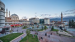
![]() Beyazıt Mosque in Bolu city center | |
Coordinates: 40°44′05″N31°36′27″E / 40.73472°N 31.60750°E | |
Country | Turkey |
Province | Bolu |
District | Bolu |
Government | |
• Mayor | Tanju Özcan (CHP) |
Elevation | 726 m (2,382 ft) |
Population (2021) [1] | 184,682 |
Time zone | UTC+3 (TRT) |
Website | www |
Bolu is a city in northern Turkey, and administrative center of the Bolu Province and of Bolu District, [2] located on the highway between Istanbul and Ankara. Its population is 184,682 (2021). [1]
The city has been governed by mayor Tanju Özcan (CHP) since local elections in 2019. It was the site of Ancient Claudiopolis and has also been called Eskihisar ("old fortress") (and as such has several Turkish namesakes).
The old highway (D-100) between Ankara and Istanbul climbs over Mount Bolu, while the new motorway (E-80) passes through Mount Bolu Tunnel, a little distance from the town. It is situated at 742 m (2,434 ft) above sea level on the southern slopes of a bare hill. [3]
Bolu was part of one of the Hittite kingdoms around 2000 BC and later 500 BC became one of the leading cities of the Greek Kingdom of Bithynia (279 BC - 79 BC). Bebryces, Mariandynes, Koukones, Thyns and Paphlagons are native people of the area in antique era. Strabo (XII, 4, 7) mentions a Hellenistic town, Bithynium (Greek : Βιθύνιον), celebrated for its pastures and cheese, which according to Pausanias (VIII, 9) was founded by Arcadians from Mantinea. [4] [5]
In the Ancient Roman era, as is shown by its coins, the town was commonly called Claudiopolis (Κλαυδιούπολις) after Emperor Claudius. It was the birthplace of Antinous, the posthumously deified lover of the Roman Emperor Hadrian, who was very generous to the city, and his name was later added to that of Claudius on the coins of the city. Emperor Theodosius II (408-50) made it the capital of a new province, formed out of Bithynia and Paphlagonia, and called by him Honorias in honour of his younger son and successor Honorius.
The city was known under Byzantine rule as Hadrianopolis (like many others; not to be confused with Hadrianopolis in Honoriade, also Constanti(n)a, now Viranşehir). After the Battle of Manzikert in which the Byzantines suffered a defeat at the hands of the Seljuks, Turkmens migrating west settled the city in the 11th century and it was referred to as Boli, Turkicized short for the Greek Polis 'city'. It was recaptured by Byzantines in 1097 but was conquered by the Seljuk Sultanate of Rum in 1197.
In 1325, the town was conquered by the Ottoman Empire under Orhan, becoming known under the present Turkish name - sometimes called Bolou or Boli. It was also ruled by Candaroğlu between 1402 and 1423. It became the chief town of a sanjak in the vilayet (province) of Kastamonu and had a population of 10,000 inhabitants. Bolu was an Ottoman eyalet (state) until the Charter of States (Vilayetler Nizannamesi) of 1864, and was within the area stretching from Beykoz kazasi of İzmid sanjak to Boyabat kazasi of Sinop sanjak. In the late 19th and early 20th century, following the 1864 Vilayetler Nizannamesi, Bolu was part of the Kastamonu Vilayet of the Empire.
As secular capital of the Roman province of Honorias, in the civil Diocese of Pontus, the bishopric of Claudiopolis became the metropolitan see, in the sway of the Patriarchate of Constantinople, with five suffragan sees : Heraclea Pontica, Prusias ad Hypium, Tium, Cratia and Hadrianopolis in Honoriade. It appears as such in the Notitiae Episcopatuum of Pseudo-Epiphanius of about 640 and in that of Byzantine Emperor Leo VI the Wise of the early 10th century, ranking sixteenth viz. seventeenth among the Patriarchate's Metropolitans.
The city, known as Hadrianopolis (like many others) under Byzantine rule fell to Turkmens migrating west in the 11th century who called it Boli, was recaptured by Byzantines in 1097, besieged unsuccessfully by the Sultanate of Rum in 1179 and conquered in 1197. Under Ottoman rule since the 14th century it lost to Heraclea Pontica the Metropolitan dignity. It ceased to exist as a residential bishopric in the 15th century.
Michel Lequien mentions twenty bishops of the see to the 13th century; documentary mentions are available for the following incumbent (Arch)bishops :
The archdiocese was nominally restored by the Roman Catholic Church as a Latin Metropolitan titular archbishopric no later than the seventeenth century, first named Claudiopolis (Latin) / Claudiopoli (Curiate Italian), renamed in 1933 as Claudiopolis in Honoriade (Latin) / Claudiopoli di Onoriade (Italiano) / Claudiopolitan(us) in Honoriade (Latin). [7]
It has been held by:
The countryside around Bolu offers excellent walking and other outdoor pursuits. There are hotels in the town. Sights near the town include:
Bolu is home to examples of Ottoman architecture. The Bayezid Grand Mosque dates to 1899, [10] commissioned by Sultan Abdul Hamid II, but was originally built by Bayezid the Thunderbolt and is home to decorations that resemble embroideries. [11] The Kadı Mosque is perhaps the best example of classical Ottoman architecture in the city, having been built in 1499 and having its entrance embroidered with ornate kündekari works. [12] [13] Other Ottoman mosques in the city include the İmaret Mosque, built in the 16th century, [14] Saraçhane Mosque, built in 1750, Ilıca Mosque, built in 1510–11, Karaköy Cuma Mosque, built in 1562-63 and Tabaklar Mosque, built in 1897. [12]
The remains of the ancient city of Bithynium have been found in four hills in the city centre, Kargatepe, Hisartepe, Hıdırlıktepe and the Uğurlunaip Hill. In Hıdırlıktepe, a tomb and the remains of a theatre have been uncovered. In Hisartepe, a temple believed to have been built by the Roman emperor Hadrian for his lover Antinous has been excavated. [12] In 1911, it was noted that "in and around [Bolu] are numerous marbles with Greek inscriptions, chiefly sepulchral, and architectural fragments." [15]
Bolu Museum was established in 1975 to display and protect artifacts found in the Bolu area. It functions as both an archaeological and an ethnographic museum and is home to 3286 archaeological and 1677 ethnographic artifacts, as well as 12,095 historical coins. The archaeological artifacts chronicle the history of the area from Neolithic to Byzantine eras. [16]
Local specialities include a sweet made of hazelnuts (which grow in abundance here) and an eau-de-cologne with the scent of grass. One feature of Bolu dear to the local people is the soft spring water (kökez suyu) obtained from fountains in the town.
Bolu is home to 12 local newspapers published in the city centre, two local TV channels (Köroğlu TV and Abant TV), three local radio stations and six local magazines. [17]
Bolu is a busy market town rather than a large city. It has one long shopping street and an attractive forested mountain countryside. Students from the university and soldiers based in Bolu make an important contribution to the local economy, which traditionally depended on forestry and handicrafts. Market day is Monday, when people from the surrounding villages come into town for their weekly shop.
The main road from Istanbul to Ankara used to cross Mount Bolu, although more people would stop at the roadside restaurants than actually come into the town, and anyway now the Mount Bolu Tunnel is open most people will rush by on the motorway rather than climb up into Bolu, especially in winter when the road has often been closed due to ice and snow. Some of the service stations on the mountain road have already announced their closure or moved elsewhere.
Bolu has a borderline oceanic climate and humid continental climate (Köppen climate classification: Cfb, or Trewartha climate classification: Dcb), with chilly, snowy winters and warm summers with cool nights. Bolu is a fairly cloudy and foggy city and annual sunshine hours are about 1,800. Unlike the low-lying, sheltered city center, many parts of the province, like Gerede, have a colder humid continental climate (Dfb/Dcb), due to cold winters.
Highest recorded temperature:42.8 °C (109.0 °F) on 15 August 2023
Lowest recorded temperature:−31.5 °C (−24.7 °F) on 5 January 1942 [18]
Climate data for Bolu (1991–2020, extremes 1929–2023) | |||||||||||||
---|---|---|---|---|---|---|---|---|---|---|---|---|---|
Month | Jan | Feb | Mar | Apr | May | Jun | Jul | Aug | Sep | Oct | Nov | Dec | Year |
Record high °C (°F) | 19.8 (67.6) | 24.1 (75.4) | 29.3 (84.7) | 31.8 (89.2) | 34.6 (94.3) | 37.0 (98.6) | 39.3 (102.7) | 42.8 (109.0) | 38.5 (101.3) | 34.4 (93.9) | 27.0 (80.6) | 23.5 (74.3) | 42.8 (109.0) |
Mean daily maximum °C (°F) | 5.8 (42.4) | 8.1 (46.6) | 11.8 (53.2) | 17.1 (62.8) | 21.9 (71.4) | 25.3 (77.5) | 28.2 (82.8) | 28.7 (83.7) | 25.0 (77.0) | 19.7 (67.5) | 13.5 (56.3) | 7.6 (45.7) | 17.7 (63.9) |
Daily mean °C (°F) | 1.1 (34.0) | 2.5 (36.5) | 5.4 (41.7) | 9.9 (49.8) | 14.5 (58.1) | 17.9 (64.2) | 20.5 (68.9) | 20.7 (69.3) | 16.6 (61.9) | 12.2 (54.0) | 6.9 (44.4) | 2.9 (37.2) | 10.9 (51.6) |
Mean daily minimum °C (°F) | −2.4 (27.7) | −1.6 (29.1) | 0.6 (33.1) | 4.2 (39.6) | 8.5 (47.3) | 11.7 (53.1) | 14.0 (57.2) | 14.2 (57.6) | 10.7 (51.3) | 7.3 (45.1) | 2.4 (36.3) | −0.6 (30.9) | 5.8 (42.4) |
Record low °C (°F) | −31.5 (−24.7) | −25.8 (−14.4) | −19.8 (−3.6) | −11.5 (11.3) | −2.3 (27.9) | 0.0 (32.0) | 2.8 (37.0) | 1.4 (34.5) | −2.5 (27.5) | −5.8 (21.6) | −24.8 (−12.6) | −29.1 (−20.4) | −31.5 (−24.7) |
Average precipitation mm (inches) | 55.6 (2.19) | 50.6 (1.99) | 56.2 (2.21) | 52.8 (2.08) | 64.2 (2.53) | 68.9 (2.71) | 28.4 (1.12) | 27.4 (1.08) | 26.5 (1.04) | 48.5 (1.91) | 40.4 (1.59) | 54.1 (2.13) | 573.6 (22.58) |
Average precipitation days | 15.53 | 14.67 | 15.73 | 13.2 | 14.2 | 12.73 | 6.17 | 5.73 | 7.63 | 10.7 | 11.2 | 15.57 | 143.1 |
Average relative humidity (%) | 81.5 | 77.6 | 73.9 | 71 | 72.9 | 73.7 | 70.5 | 70.1 | 72.4 | 76.9 | 77.3 | 81.5 | 74.9 |
Mean monthly sunshine hours | 52.7 | 76.3 | 117.8 | 156.0 | 198.4 | 225.0 | 260.4 | 251.1 | 186.0 | 127.1 | 90.0 | 52.7 | 1,793.5 |
Mean daily sunshine hours | 1.7 | 2.7 | 3.8 | 5.2 | 6.4 | 7.5 | 8.4 | 8.1 | 6.2 | 4.1 | 3.0 | 1.7 | 4.9 |
Source 1: Turkish State Meteorological Service [19] | |||||||||||||
Source 2: NOAA NCEI(humidity) [20] |
Edirne, historically known as Adrianople, is a city in Turkey, in the northwestern part of the province of Edirne in Eastern Thrace. Situated 7 km (4.3 mi) from the Greek and 20 km (12 mi) from the Bulgarian borders, Edirne was the second capital city of the Ottoman Empire from 1360s to 1453, before Constantinople became its capital.
Bolu Province is a province in north-western Turkey, between the capital, Ankara, and the largest city in the country, Istanbul. Its area is 8,313 km,2, and its population is 320,824 (2022). The capital city of the province is Bolu.
Gelibolu is a town in Çanakkale Province of the Marmara Region, located in Eastern Thrace in the European part of Turkey. It is located on the southern shore of the peninsula named after it on the Dardanelles strait, 3 kilometres (1.9 mi) away from Lapseki on the other shore. It is the seat of Gelibolu District. Its population is 31,782 (2021).
Galata is the former name of the Karaköy neighbourhood in Istanbul, which is located at the northern shore of the Golden Horn. The district is connected to the historic Fatih district by several bridges that cross the Golden Horn, most notably the Galata Bridge. The medieval citadel of Galata was a colony of the Republic of Genoa between 1273 and 1453. The famous Galata Tower was built by the Genoese in 1348 at the northernmost and highest point of the citadel. Galata is now a quarter within the district of Beyoğlu in Istanbul.
Isparta is a city in western Turkey. It is the seat of Isparta Province and Isparta District. Its population is 247,580 (2022). Its elevation is 1035 m. It is known as the "City of Roses". Isparta is well-connected to other parts of Turkey via roads. Antalya lies 130 km to the south and Eskişehir is 350 km to the north. Süleyman Demirel University has introduced thousands of youths from varied backgrounds to the city's mostly conservative fabric in recent years. The city's football team, Ispartaspor, plays in Group 7 of the Turkish Regional Amateur League.
Amasya is a city in northern Turkey, in the Black Sea Region. It was called Amaseia or Amasia in antiquity. It is the seat of Amasya Province and Amasya District. Its population is 114,921 (2021). Amasya stands in the mountains above the Black Sea (Karadeniz) coast, set apart from the rest of Anatolia in a narrow valley along the banks of the Yeşilırmak River. Although near the Black Sea, this area is high above the coast and has an inland climate, well-suited to growing apples, for which Amasya province, one of the provinces in north-central Anatolia Turkey, is famed. It was the home of the geographer Strabo and the birthplace of the 15th century Armenian scholar and physician Amirdovlat Amasiatsi. Located in a narrow cleft of the Yeşilırmak (Iris) river, it has a history of 7,500 years with many traces still evident today.
Aksaray is a city in the Central Anatolia region of Turkey. It is the seat of Aksaray Province and Aksaray District. Its population is 247,147 (2021). In 2021 the province had an estimated population of 429,069 distributed over about 7,659 km2 (2,957 sq mi). The average elevation is 980 m (3,215 ft), with the highest point being Mt. Hasan at 3,268 m (10,722 ft).
Arap Mosque is a mosque in the Karaköy quarter of Istanbul, Turkey. The building was originally a Roman Catholic church erected in 1325 by the friars of the Dominican Order, near or above an earlier chapel dedicated to Saint Paul in 1233. Although the structure was altered during the Ottoman period, it is the only example of medieval religious Gothic architecture remaining in Istanbul.
The Bayezid II Mosque is an early 16th-century Ottoman imperial mosque located in Beyazıt Square in Istanbul, Turkey, near the ruins of the Forum of Theodosius of ancient Constantinople.
Kütahya is a city in western Turkey which lies on the Porsuk River, at 969 metres above sea level. It is the seat of Kütahya Province and Kütahya District. Its population is 263,863 (2022). The region of Kütahya has large areas of gentle slopes with agricultural land culminating in high mountain ridges to the north and west.
Gerede is a town in Bolu Province in the Black Sea region of Turkey. It is located on the highway from Istanbul to Ankara. It is the seat of Gerede District. Its population is 23,547 (2021). Elevation is about 1,300 m. The mayor is Mustafa Allar (AKP).
Mudurnu is a small town in Bolu Province in the Black Sea region of Turkey, 52 km south-west of the city of Bolu. It is the seat of Mudurnu District. Its population is 5,379 (2021). The mayor is Necdet Türker (MHP), elected in 2019.
Ermenek is a town in Karaman Province in the Mediterranean region of Turkey. It is the seat of Ermenek District. Its population is 11,629 (2022). As ancient Germanicopolis, a former bishopric, it remains a Latin Catholic titular see.
Bithynium or Bithynion was an ancient city in Bithynia. Its site is occupied by the modern town of Bolu, Asiatic Turkey.
Bodrum Mosque in Istanbul, Turkey, is a former Eastern Orthodox church converted into a mosque by the Ottomans. The church was known under the Greek name of Myrelaion.
Veria, officially transliterated Veroia, historically also spelled Beroea or Berea, is a city in Central Macedonia, in the geographic region of Macedonia, northern Greece, capital of the regional unit of Imathia. It is located 511 kilometres north-northwest of the capital Athens and 73 km (45 mi) west-southwest of Thessaloniki.
The Kesik Minare Cami, Korkut Cami or Cumanın Cami standing in the streets of Kaleiçi in southern Turkey, was originally built as a Roman temple in the 2nd century AD. In the 7th century, it was converted into a Byzantine church in honor of the Virgin Mary, but it was heavily damaged in the 7th century during the Arab invasions. In the 9th century it was repaired again. The minaret was added in the early 13th century when the Sultanate of Rum established their rule in Antalya and converted the church into a mosque. In 1361, when the crusader king of Cyprus took Antalya from the Seljuks, it was consecrated a church again, only to become a mosque once more during the rule of Şehzade Korkut, son of the Ottoman sultan Bayezid II. The main building was destroyed in a fire in 1800, but the surviving minaret, located today on Kaleiçi Hespçi Street, is known as the Kesik Minare.
The Grand Mosque of Bursa is a historic mosque in Bursa, Turkey. It was commissioned by the Ottoman Sultan Bayezid I to commemorate his great victory at the Battle of Nicopolis and built between 1396 and 1399. The mosque is a major monument of early Ottoman architecture and one of the most important mosques in the city, located in the heart of the old city alongside its historic markets.
Claudiopolis was an ancient city in the Roman province of Paphlagonia in northern Asia Minor.
Milas is a municipality and district of Muğla Province, Turkey. Its area is 2,067 km2, and its population is 147,416 (2022). The city commands a region with an active economy and is very rich in history and ancient remains, the territory of Milas containing a remarkable twenty-seven archaeological sites of note. The city was the first capital of ancient Caria and of the Anatolian beylik of Menteşe in mediaeval times. The nearby Mausoleum of Hecatomnus is classified as a tentative UNESCO World Heritage Site.
WMO station number: 17070
This article incorporates text from a publication now in the public domain : Pétridès, Sophrone (1908). "Claudiopolis". In Herbermann, Charles (ed.). Catholic Encyclopedia . Vol. 4. New York: Robert Appleton Company.