The Boston Planning and Development Agency (BPDA), formerly the Boston Redevelopment Authority (BRA), is a Massachusetts public agency that serves as the municipal planning and development agency for Boston, working on both housing and commercial developments.
Massachusetts, officially the Commonwealth of Massachusetts, is the most populous state in the New England region of the northeastern United States. It borders on the Atlantic Ocean to the east, the states of Connecticut and Rhode Island to the south, New Hampshire and Vermont to the north, and New York to the west. The state is named after the Massachusett tribe, which once inhabited the east side of the area, and is one of the original thirteen states. The capital of Massachusetts is Boston, which is also the most populous city in New England. Over 80% of the population of Massachusetts lives in the Greater Boston metropolitan area, a region influential upon American history, academia, and industry. Originally dependent on agriculture, fishing and trade, Massachusetts was transformed into a manufacturing center during the Industrial Revolution. During the 20th century, Massachusetts's economy shifted from manufacturing to services. Modern Massachusetts is a global leader in biotechnology, engineering, higher education, finance, and maritime trade.
As an agency concerned with urban planning, the BPDA does not consider requests for zoning variances from individual property owners. These are heard by the city's own Zoning Board of Appeals, a seven-person body appointed by the Mayor of Boston. [1]
Urban planning is a technical and political process concerned with the development and design of land use and the built environment, including air, water, and the infrastructure passing into and out of urban areas, such as transportation, communications, and distribution networks. Urban planning deals with physical layout of human settlements. The primary concern is the public welfare, which includes considerations of efficiency, sanitation, protection and use of the environment, as well as effects on social and economic activities. Urban planning is considered an interdisciplinary field that includes social engineering and design sciences. It is closely related to the field of urban design and some urban planners provide designs for streets, parks, buildings and other urban areas. Urban planning is also referred to as urban and regional planning, regional planning, town planning, city planning, rural planning, urban development or some combination in various areas worldwide.
Zoning in the United States includes various land use laws falling under the police power rights of state governments and local governments to exercise authority over privately owned real property. The earliest zoning laws originated with the Los Angeles zoning ordinances of 1908 and the New York City Zoning resolution of 1916. Starting in the early 1920s, the United States Commerce Department drafted model zoning and planning ordinances in the 1920s to facilitate states in drafting enabling laws. Also in the early 1920s, a lawsuit challenged a local zoning ordinance in a suburb of Cleveland, which was eventually reviewed by the United States Supreme Court.
The mayor of Boston is the head of the municipal government in Boston, Massachusetts. Boston has a mayor-council system of government. Boston's mayoral elections are non-partisan, and elect a mayor to a four-year term; there are no term limits. The mayor's office is in Boston City Hall, in Government Center.
Some consider the BPDA's roles as both real estate owner and developer, and approval authority over private development projects, to be a conflict of interest. [2]
A conflict of interest (COI) is a situation in which a person or organization is involved in multiple interests, financial or otherwise, and serving one interest could involve working against another. Typically, this relates to situations in which the personal interest of an individual or organization might adversely affect a duty owed to make decisions for the benefit of a third party.
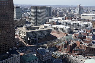
One of the first projects the BRA took on was the demolition of the West End of Boston, in an infamous urban renewal project that generated a considerable negative reaction locally and across the country. At the same time, nineteenth-century buildings around Scollay Square were demolished to make way for the new Government Center. [3] Many consider the finished project (which includes Boston City Hall) an eyesore, and the surrounding large brick plaza as an uncomfortable place to be. [4] Another urban renewal project was the Prudential Tower development over the Boston and Albany Railroad right-of-way in Back Bay; as part of this project, Mechanics Hall on Huntington Avenue was taken by the city using eminent domain and demolished in 1959.
Urban renewal is a program of land redevelopment often used to address urban decay in cities. Urban renewal is the clearing out of blighted areas in inner cities to clear out slums and create opportunities for higher class housing, businesses, and more.
Scollay Square was a vibrant city square in downtown Boston, Massachusetts. It was named for William Scollay, a prominent local developer and militia officer who bought a landmark four-story merchant building at the intersection of Cambridge and Court Streets in 1795. Local citizens began to refer to the intersection as Scollay's Square, and, in 1838, the city officially memorialized the intersection as Scollay Square. Early on, the area was a busy center of commerce, including daguerreotypist (photographer) Josiah Johnson Hawes (1808–1901) and Dr. William Thomas Green Morton, the first dentist to use ether as an anaesthetic.
Boston City Hall is the seat of city government of Boston, Massachusetts. It includes the offices of the mayor of Boston and the Boston City Council. The current hall was built in 1968 to assume the functions of the Old City Hall.
The BRA is currently collaborating with the Massachusetts Turnpike Authority and Rose Kennedy Greenway Conservancy on various development projects such as the Rose Kennedy Greenway, which is being developed atop the Big Dig and is opening up the waterfront to pedestrians. The BRA owns real estate throughout the city and together with community participation through planning initiatives, issues Requests for Proposals as part of the land disposition process in order to achieve neighborhood-based community development goals. Another example of the BRA's work involves collaboration with the State Coastal Zone Management Department for waterfront planning and redevelopment of privately owned and MassPort-owned properties. An example of municipal harbor planning involves the "East Boston Municipal Harbor Plan" where properties of varied ownership along the waterfront are currently being developed [5] and Fort Point Channel development.
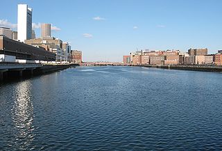
Fort Point Channel is a maritime channel separating South Boston from downtown Boston, Massachusetts, feeding into Boston Harbor. The south part of it has been gradually filled in for use by the South Bay rail yard and several highways. At its south end, the channel once widened into South Bay, from which the Roxbury Canal continued southwest where the Massachusetts Avenue Connector is now. The Boston Tea Party occurred at its northern end. The channel is surrounded by the Fort Point neighborhood, which is also named after the same colonial-era fort.
The BRA has also undertaken improvements on Columbia Road in Dorchester, a narrow stretch of green space that Frederick Law Olmsted once envisioned as The Dorchesterway, the final link in the Emerald Necklace park system. [6]
An open space reserve is an area of protected or conserved land or water on which development is indefinitely set aside.
Frederick Law Olmsted was an American landscape architect, journalist, social critic, and public administrator. He is popularly considered to be the father of American landscape architecture. Olmsted was famous for co-designing many well-known urban parks with his senior partner Calvert Vaux, including Central Park in New York City, Prospect Park in Brooklyn, New York and Cadwalader Park in Trenton.
The Emerald Necklace consists of a 1,100-acre chain of parks linked by parkways and waterways in Boston and Brookline, Massachusetts. It gets its name from the way the planned chain appears to hang from the "neck" of the Boston peninsula; to this day it is not fully constructed. In 1989 the Emerald Necklace Parks was designated as Boston Landmark by the Boston Landmarks Commission.
Officially a "public body politic and corporate," the BRA was established by the Massachusetts General Court and the Boston City Council in 1957, superseding the authority of the Boston Housing Authority. Its primary goal is to work with Boston businesses and developers in order to provide direction for development in the city of Boston.
Its statutory authority was set forth in the Massachusetts General Laws chapter 121B, section 4, and amended by the Session Laws of 1960, chapter 652, section 12. The agency's redevelopment authority includes the jurisdiction to buy and sell real estate, acquire real estate through eminent domain, and grant tax concessions to encourage commercial and residential development. [7]
On September 27, 2016, Boston Mayor Martin J. Walsh changed the name of the development agency from the Boston Redevelopment Authority (BRA) to the Boston Planning and Development Agency (BPDA). This change was part of a broader goal to make city government more transparent and to put a friendlier face to a bureaucratic agency that rules upon major construction in the city. [8]
Government Center is an area in downtown Boston, centered on City Hall Plaza. Formerly the site of Scollay Square, it is now the location of Boston City Hall, courthouses, state and federal office buildings, and a major MBTA subway station, also called Government Center. Its development was controversial, as the project displaced thousands of residents and razed several hundred homes and businesses.
Empire State Development (ESD) is the umbrella organization for New York's two principal economic development public-benefit corporations, the New York State Urban Development Corporation (UDC) and the New York Job Development Authority (JDA). The New York State Department of Economic Development (DED) is a department of the New York government that has been operationally merged into ESD.
Redevelopment is any new construction on a site that has pre-existing uses.
The Rose Fitzgerald Kennedy Greenway is a linear park located in several Downtown Boston neighborhoods. It consists of landscaped gardens, promenades, plazas, fountains, art, and specialty lighting systems that stretch over one mile through the Chinatown, Financial District, Waterfront, and North End neighborhoods. Officially opened in October 2008, the 17-acre Greenway sits on land created from demolition of the John F. Fitzgerald Expressway under the Big Dig.
Lee Tung Street, known as the Wedding Card Street by locals, was a street in Wan Chai, Hong Kong. The street was famed in Hong Kong and abroad as a centre for publishing and for the manufacturing of wedding cards and other similar items.
The South Waterfront is a high-rise district under construction on former brownfield industrial land in the South Portland neighborhood south of downtown Portland, Oregon, U.S. It is one of the largest urban redevelopment projects in the United States. It is connected to downtown Portland by the Portland Streetcar and MAX Orange Line, and to the Oregon Health & Science University (OHSU) main campus atop Marquam Hill by the Portland Aerial Tram, as well as roads to Interstate 5 and Oregon Route 43.
The West End is a neighborhood of Boston, Massachusetts, bounded generally by Cambridge Street to the south, the Charles River to the west and northwest, North Washington Street on the north and northeast, and New Sudbury Street on the east. Beacon Hill is to the south, and the North End is to the east. A late 1950s urban renewal project razed a large Italian and Jewish enclave and displaced over 20,000 people in order to redevelop much of the West End and part of the neighboring Downtown neighborhood. Today, much of the original West End is non-residential, including part of Government Center as well as much of Massachusetts General Hospital and several high rise office buildings.
Mixed-use development is a term used for two related concepts:
The Harbor Towers are two 40-story residential towers located on the waterfront of Boston, Massachusetts, located between the New England Aquarium and the Rowes Wharf mixed-use development. Harbor Towers I, the taller of the two towers, stands at 400.0 feet (121.9 m), while Harbor Towers II rises 396 feet (121 m). Harbor Towers I is in a tie as 29th-tallest building in Boston. They were designed by Henry N. Cobb of I. M. Pei & Partners.
The Hudson River Waterfront Walkway, also known as the Hudson River Walkway, is an ongoing and incomplete project located on Kill van Kull and the western shore of Upper New York Bay and the Hudson River, implemented as part of a New Jersey state-mandated master plan to connect the municipalities from the Bayonne Bridge to the George Washington Bridge with an urban linear park and provide contiguous unhindered access to the water's edge.
Assembly Square is a neighborhood in Somerville, Massachusetts. It is located along the west bank of the Mystic River, bordered by Ten Hills and Massachusetts Route 28 to the north and the Charlestown neighborhood of Boston to the south. The district's western border runs along Interstate 93. Located 2.5 miles (4.0 km) from downtown Boston, the 143 acres (580,000 m2) parcel is named for a former Ford Motor Company plant that closed in 1958.
Columbia Point, in the Dorchester neighborhood of Boston, Massachusetts sits on a peninsula jutting out from the mainland of eastern Dorchester into the bay. Old Harbor Park is on the north side, adjacent to Old Harbor, part of Dorchester Bay. The peninsula is primarily occupied by Harbor Point, the University of Massachusetts Boston, the John F. Kennedy Presidential Library and Museum, the Edward M. Kennedy Institute for the United States Senate, and a complex at the former Bayside Expo Center, Boston College High School, and the Massachusetts Archives. The Boston Harborwalk follows the entire coastline.
Boston Harborwalk is a public walkway that follows the edge of piers, wharves, beaches, and shoreline around Boston Harbor. When fully completed it will extend a distance of 47 miles (76 km) from East Boston to the Neponset River.
The Boston Housing Authority (BHA) is a public agency of the city of Boston, Massachusetts that provides subsidized public housing to low- and moderate-income families and individuals.
The Seaport District, or simply the Seaport, is a neighborhood in Boston, Massachusetts. It is considered part of South Boston and has gone under a dramatic redevelopment effort in recent years. It is bordered by the Fort Point Channel to the west, Boston Harbor to the north and east, and South Boston to the south. It is sometimes referred to as The South Boston Waterfront.
The Town Planning Board is a statutory body of the Hong Kong Government tasked with developing urban plans with an aim to ensuring the "health, safety, convenience and general welfare of the community through the process of guiding and controlling the development and use of land, and to bring about a better organised, efficient and desirable place to live and work." It is founded upon section 2 of the Town Planning Ordinance.
The Boston Public Market is an indoor public market that opened in July 2015 in downtown Boston, adjacent to the Rose Fitzgerald Kennedy Greenway. The market houses more than 35 year-round vendor stalls, and is open seven days a week. An outdoor farmers' market that is open on Sundays and Wednesdays from May to November began in 2014 on the plaza next to the building. Vendors for the indoor market are selected by the operator, the non-profit Boston Public Market Association, and must sell food and other products that are produced or originate in New England, as well as a limited amount of certain produce that is not able to grow in New England. The market was the first in the United States with an all-local-food requirement. That being said, the requirement was not met by all vendors. The association operates a second seasonal outdoor farmers' market in Dewey Square, near the southern end of the Greenway.
Haymarket in Boston is an open-air market on Blackstone, Hanover, and North Streets, next to the Rose Fitzgerald Kennedy Greenway between the North End and Government Center.
The Fallon Company is a privately held commercial real estate owner and developer headquartered in Boston, Massachusetts. Founded by Joseph F. Fallon in 1993, The Fallon Company has developed over $4 billion in real estate, representing more than six million square feet of property. The company is recognized as a leader in mixed-use urban development and one of the most active private developers on the East Coast. The company focuses on large-scale urban design geared toward transforming neighborhoods into cohesive, community-driven environments. With offices in Boston and Charlotte, The Fallon Company has the capacity and resources to undertake projects throughout the United States.