Elkhorn is a census-designated place (CDP) in Jefferson County, Montana, United States, in the Elkhorn Mountains of the southwestern part of the state. As of the 2010 census it had a population of 10. The community is considered a ghost town, and two of its buildings are preserved as Elkhorn State Park.
The Montana Department of Corrections is a state agency of Montana that operates state prisons and manages community-corrections programs. The agency has its headquarters in Helena.

The Boulder River is a 77-mile (124 km) tributary of the Jefferson River in southwestern Montana in the United States.
Boulder River may refer to:
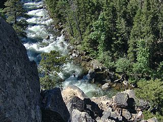
The Boulder River is a tributary of the Yellowstone River, approximately 60 mi (96 km) long, in south central Montana in the United States. It is one of two rivers named the Boulder River in Montana.

Ringing rocks, also known as sonorous rocks or lithophonic rocks, are rocks that resonate like a bell when struck, such as the Musical Stones of Skiddaw in the English Lake District; the stones in Ringing Rocks Park, in Upper Black Eddy, Bucks County, Pennsylvania; the Ringing Rocks of Kiandra, New South Wales; and the Bell Rock Range of Western Australia. Ringing rocks are used in idiophonic musical instruments called lithophones.

The Beaverhead-Deerlodge National Forest is the largest of the National Forests in Montana, United States. Covering 3.36 million acres (13,600 km2), the forest is broken into nine separate sections and stretches across eight counties in the southwestern area of the state. President Theodore Roosevelt named the two forests in 1908 and they were merged in 1996. Forest headquarters are located in Dillon, Montana. In Roosevelt's original legislation, the Deerlodge National Forest was called the Big Hole Forest Reserve. He created this reserve because the Anaconda Copper Mining Company, based in Butte, Montana, had begun to clearcut the upper Big Hole River watershed. The subsequent erosion, exacerbated by smoke pollution from the Anaconda smelter, was devastating the region. Ranchers and conservationists alike complained to Roosevelt, who made several trips to the area.
(Munday 2001)
Montana Highway 69 (MT 69) is a route running northerly from an intersection with MT 55 in the community of Whitehall. The highway extends approximately 38 miles (61 km) to an intersection with Interstate 15 (I-15) at the northern edge of the town of Boulder. Most of the route follows the Boulder River valley, a scenic and relatively unspoiled rural landscape.

Powderville, also Elkhorn Crossing is an unincorporated community in northeastern Powder River County, Montana, United States, along the Powder River. It is a small cluster of buildings that lies along local roads northeast of the town of Broadus, the county seat of Powder River County. Its elevation is 2,828 feet (862 m).
The Horseshoe Hills, el. 6,673 feet (2,034 m), are a roughly crescent-shaped range of hills north of Manhattan, Montana in Gallatin County, Montana. They lie in the area between the southern Big Belt Mountains and the northern Bridger Range. The hills are bounded on the north by Sixteen Mile Creek, the first major tributary of the Missouri River. As they are in the rain shadow of the Boulder, Elkhorn, and Bull Mountains to the west, the Horseshoe Hills are notably dry, receiving 10 - 12 inches of precipitation annually. This is especially true on the southern and southeastern flanks, which are also in the rain shadow of the hills themselves. In the driest areas, Missouri foxtail cacti, plains prickly pear cacti, and yucca abound, as well as prairie rattlesnakes. Much of the hills are private property, but there is also some State, BLM, and National Forest land.

Confederate Gulch is a steeply incised gulch or valley on the west-facing slopes of the Big Belt Mountains in the U.S. state of Montana. Its small stream drains westward into Canyon Ferry Lake, on the upper Missouri River near present-day Townsend, Montana. In 1864, Confederate soldiers on parole during the American Civil War made a minor gold discovery in the gulch, but the discovery of the sensationally rich Montana Bar the following year—one of the richest placer strikes per acre ever made—led to other rich gold strikes up and down the gulch, and touched off a frantic boom period of placer gold mining in the area that extended through 1869. From 1866 to 1869, the gulch equaled or outstripped all other mining camps in the Montana Territory in gold production, producing an estimated $19–30 million worth of gold. For a time, Confederate Gulch was the largest community in Montana. In 1866, Montana had a total population of 28,000, and of these, about 10,000 (35%) were working in Confederate Gulch.
Michael "Mick" Dennehy is a former American football player and coach. He served as the head football coach at the University of Montana Western (1988–1990), the University of Montana (1996–1999), and Utah State University (2000–2004), compiling a career college football record of 68–62.

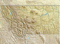
The Regional designations of Montana vary widely within the U.S state of Montana. The state is a large geographical area that is split by the Continental Divide, resulting in watersheds draining into the Pacific Ocean, Gulf of Mexico and Hudson's Bay. The state is approximately 545 miles (877 km) east to west along the Canada–United States border and 320 miles (510 km) north to south. The fourth largest state in land area, it has been divided up in official and unofficial ways into a variety of regions. Additionally, Montana is part of a number of larger federal government administrative regions.
In the U.S. state of Montana, Interstate 15 continues onward from Idaho for nearly 400 miles (640 km) through the cities of Butte, Helena and Great Falls, intersecting with Interstate 90, Interstate 115 and Interstate 315. Interstate 15 reaches its northern terminus at the international border with Alberta, Canada.

The basin that held Pleistocene Lake Musselshell is in the lower (north-flowing) reach of the river. It is underlain mostly by highly erodible Cretaceous Colorado shale, Montana group sandstone, siltstone and shale, and Hell Creek sandstone and shale. The bedrock is gently folded and affected by local faults and joints. There is a sequence of nine terraces and more than 100 glacial boulders. The terraces are older than the erratics as the erratics rest on the terraces.
Lake Chouteau was a glacial lake formed during the late Pleistocene along the Teton River. After the Laurentide ice sheet retreated, water melting off the glacier accumulated between the Rocky Mountains and the ice sheet. The lake drained along the front of the ice sheet, eastward towards the Judith River and the Missouri River.