Charles Bulfinch was an early American architect, and has been regarded by many as the first American-born professional architect to practice.

Beacon Hill is a historic neighborhood in Boston, Massachusetts, United States, and the hill upon which the Massachusetts State House resides. The term "Beacon Hill" is used locally as a metonym to refer to the state government or the legislature itself, much like Washington, D.C.'s Capitol Hill does at the federal level.

Solomon Willard was a carver and builder in Massachusetts who is remembered primarily for designing and overseeing the Bunker Hill Monument, the first monumental obelisk erected in the United States.

The West End is a neighborhood of Boston, Massachusetts, United States, bounded generally by Cambridge Street to the south, the Charles River to the west and northwest, North Washington Street on the north and northeast, and New Sudbury Street on the east. Beacon Hill is to the south, North Point is across the Charles River to the north, Kendall Square is across the Charles River to the west, and the North End is to the east. A late 1950s urban renewal project razed a large Italian and Jewish enclave and displaced over 20,000 people in order to redevelop much of the West End and part of the neighboring Downtown neighborhood. After that, the original West End became increasingly non-residential, including part of Government Center as well as much of Massachusetts General Hospital and several high rise office buildings. More recently, however, new residential buildings and spaces, as well as new parks, have been appearing across the West End.

Tremont Street is a major thoroughfare in Boston, Massachusetts.

Charles Street is the name of a north-south street in the city center of Boston, Massachusetts. It begins in the north at Leverett Circle, where it connects with Nashua Street and Monsignor O'Brien Highway. Science Park station on the MBTA Green Line is located there. Charles Street runs south and gives its name to the Charles/MGH station on the MBTA Red Line, connecting via the Charles Circle rotary to Cambridge Street and the Longfellow Bridge which leads to Cambridge. This segment is a one-way street, with traffic heading northwards.

The Congregational Library & Archives is an independent special collections library and archives. It is located on the second floor of the Congregational House at 14 Beacon Street in the Beacon Hill neighborhood of Boston, Massachusetts. The Library was founded in 1853 by a gathering of Congregational ministers and has since evolved into a professional library and archives that holds more than 250,000 items, predominantly focused on 18th to 21st century American Congregational history. The Library's reading room is free and open to the public for research but the Library's stacks are closed and book borrowing privileges are extended exclusively to members.

St. Stephen's Church is a historic church in the North End of Boston, Massachusetts. It was built in 1802–1804 as the New North Church or New North Meeting House and was designed by the noted architect Charles Bulfinch. It is the only one of the five churches he designed in Boston to remain extant. The church replaced one which had been built on the site in 1714 and enlarged in 1730. The Congregationalist church became Unitarian in 1813, and the church was sold to the Roman Catholic Diocese in 1862, and renamed St. Stephen's. It was restored and renovated in 1964-65 by Chester F. Wright, and was added to the National Register of Historic Places in 1975.

Franklin Place, designed by Charles Bulfinch and built in Boston, Massachusetts, in 1793–95, included a row of sixteen three-story brick townhouses that extended in a 480-foot curve, a small garden, and four double houses. Constructed early in Bulfinch's career, Franklin Place came after he had seen the possibilities of modern architecture in Europe and had determined to reshape his native city. It was the first important urban housing scheme undertaken in the United States, and the city's first row-house complex. However, years of decline and the push of industry into the area forced its demolition in 1858.

The Brattle Street Church (1698–1876) was a Congregational and Unitarian church on Brattle Street in Boston, Massachusetts.
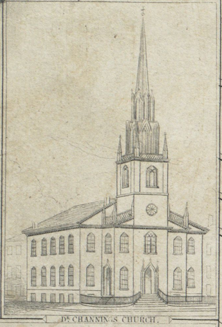
The Federal Street Church was a congregational Unitarian church in Boston, Massachusetts. Organized in 1727, the originally Presbyterian congregation changed in 1786 to "Congregationalism", then adopted the liberal theology of its fifth Senior Minister, William Ellery Channing, (1780–1842). For most of the 18th century the church was known as the Long Lane Meeting-House. In 1788, state leaders met in the relatively spacious building to determine Massachusetts' ratification of the United States Constitution. Thereafter the church renamed itself the Federal Street Church in honor of the event. In 1803, it called William Ellery Channing, (1780–1842), as its minister who defined "Unitarian Christianity" and launched the Unitarian movement, making the Federal Street Church one of the first to define itself as Unitarian.

The Amory–Ticknor House is a historic house at 9–10 Park Street and 22–22A Beacon Street in Boston, Massachusetts. It was built in 1804 by businessman Thomas Coffin Amory, and later owned by scholar George Ticknor. It sits atop Beacon Hill, across from the Massachusetts State House on Beacon Street and the Boston Common on Park Street. Numerous tenants have occupied various parts of the house through the years, including Samuel Dexter, Christopher Gore, John Jeffries, Harrison Gray Otis, Anna Ticknor's Society to Encourage Studies at Home, and temporarily in 1824, the Marquis de Lafayette.

Federal Street is a street in the Financial District of Boston, Massachusetts. Prior to 1788, it was known as Long Lane. The street was renamed after state leaders met there in 1788 to determine Massachusetts' ratification of the United States Constitution.
Court Street is located in the Financial District of Boston, Massachusetts. Prior to 1788, it was called Prison Lane (1634–1708) and then Queen Street (1708–1788). In the 19th century it extended beyond its current length, to Bowdoin Square. In the 1960s most of Court Street was demolished to make way for the construction of Government Center. The remaining street extends a few blocks, near the Old State House on State Street.
Franklin Street is located in the Financial District of Boston, Massachusetts, United States. It was developed at the end of the 18th century by Charles Bulfinch, and included the now-demolished Tontine Crescent and Franklin Place.

Bowdoin Square in Boston, Massachusetts was located in the West End. In the 18th and 19th centuries it featured residential houses, leafy trees, a church, hotel, theatre and other buildings. Among the notables who have lived in the square: physician Thomas Bulfinch; merchant Kirk Boott; and mayor Theodore Lyman. The urban renewal project in the West End in the 1950s removed Green Street and Chardon Street, which formerly ran into the square, and renamed some existing streets; it is now a traffic intersection at Cambridge Street, Bowdoin Street, and New Chardon Street.
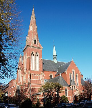
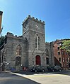
The Church of the Advent is an Episcopal parish in Boston, Massachusetts, United States. The church is housed in a Victorian Gothic building, faced in brick with eight large change ringing bells and a 172-foot spire. It has long been a prominent center of Anglo-Catholic worship.
Duncan Convers was a prominent American Anglo-Catholic priest, author, and social commentator. He was born in Zanesville, Ohio, made deacon on June 11, 1876, and ordained priest on December 20, 1876, following studies at Nashotah House Theological Seminary. Convers served initially in the Missionary Diocese of Colorado. In 1886 he was professed as a mission priest of the Society of Saint John the Evangelist and began missionary service in Philadelphia. He was elected rector of S. Clement's Church, Philadelphia in succession to Basil Maturin SSJE in 1889 and served in that position until 1891. He subsequently served at the SSJE's mission Church of Saint John the Evangelist, Bowdoin Street, in Beacon Hill, Boston.