
Saunderton is a village and former civil parish, now in the parish of Bledlow-cum-Saunderton, Buckinghamshire, England. It is in the Saunderton Valley in the Chiltern Hills. It is 2 miles (3 km) southwest of Princes Risborough, Saunderton Lee, about 2 miles (3 km) further south and a residential area on the A4010 road around Saunderton railway station, it is 5 miles (8 km) northwest of High Wycombe.

South Kesteven is a local government district in Lincolnshire, England, forming part of the traditional Kesteven division of the county. Its council is based in Grantham. The district also includes the towns of Bourne, Market Deeping and Stamford, along with numerous villages and surrounding rural areas.

Belton is a village in the civil parish of Belton and Manthorpe, in the South Kesteven district of Lincolnshire, England. It is situated on the A607 road, and 3 miles (5 km) north from the market town of Grantham. In 1921 the parish had a population of 145.

Uffington is a village and civil parish in the South Kesteven district of Lincolnshire, England. The population of the civil parish at the 2011 census was 686. It is in the valley of the River Welland, between Stamford and The Deepings.
Litchfield is a village and former civil parish, now in the parish of Litchfield and Woodcott, in the Basingstoke and Deane district of Hampshire, England. It is closely bypassed by the A34 trunk road between Newbury and Whitchurch, which follows the course of the former Didcot, Newbury and Southampton Railway. Litchfield railway station, which closed in 1960, was on this line. The station is a private house, not owned by C.A.H Wills who owns Litchfield farms estate and lives in the village. The station was sold by Hampshire County Council in 1978 and has been restored. The approach road is now a private drive to the property. In 1976 the Litchfield - Whitchurch bypass was opened and made use of the DN&SR trackbed south of Litchfield towards Whitchurch for a distance of one mile. In 1931 the parish had a population of 88.

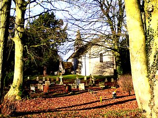
Thurlby is a village and civil parish in the South Kesteven district of Lincolnshire, England. It is situated just west of the A15 road, 2 miles (3 km) south from the town of Bourne, and on the edge of the Lincolnshire Fens. It is sometimes referred to as Thurlby by Bourne to distinguish it from other villages in Lincolnshire with the same name. Thurlby and the hamlet of Northorpe to its north are conjoined. The parish had a population of 2,136 at the 2001 census and 2,153 at the 2011 census.

Braceborough and Wilsthorpe is a civil parish in the South Kesteven district of Lincolnshire, England. Braceborough and Wilsthorpe are less than 1 mile (1.6 km) apart, separated by the East Glen River. Braceborough and Wilsthorpe are located between the A6121 road, which goes from Stamford to Bourne, and the A15, this links Bourne and Market Deeping. It is approximately 12 miles (19 km) north-west from its nearest city, Peterborough. Before the 1930s Braceborough and Wilsthorpe were separate parishes but in 1931 the two were dissolved and joined together to form today's civil parish.

Greatford is a village and civil parish in the South Kesteven district of Lincolnshire, England. It is situated 2 miles (3 km) west from the A15, 4.5 miles (7 km) north-east from Stamford, and 5 miles (8 km) south from Bourne. Greatford is noted for Greatford Hall, once the home of Francis Willis.

Barholm is a village in the civil parish of Barholm and Stowe, in the South Kesteven district of Lincolnshire, England. It is 2 miles (3 km) west from the A15 road, and 6 miles (10 km) south from Bourne. In 1921 the parish had a population of 170.
Kirkstead is a village and former civil parish now in the parish of Woodhall Spa, in the East Lindsey district, in Lincolnshire, England, on the River Witham. In 1961 the parish had a population of 85. It was merged with the civil parish of Woodhall Spa in 1987.

Haconby is a village and civil parish in the South Kesteven district of Lincolnshire, England. The population of the civil parish at the 2001 census was 448 increasing to 532 at the 2011 census. It is situated on the western edge of the Lincolnshire Fens, 3 miles (5 km) north from Bourne.

Creeton is a village in the civil parish of Counthorpe and Creeton in the South Kesteven district of Lincolnshire, England. It is situated 3 miles (5 km) south west from Bourne and 3 miles (4.8 km) south from Corby Glen, on the River Glen. In 1921 the parish had a population of 72. On 1 April 1931 the parish was abolished and merged with Counthorpe to form "Counthorpe and Creeton".

Careby is the principal village in the civil parish of Careby Aunby and Holywell, in the South Kesteven district of South Kesteven, Lincolnshire, England. The River West Glen flows through the parish, near Careby, forming part of the parish boundary. In 1921 the parish had a population of 116. On 1 April 1931 the parish was abolished to form "Careby, Aunby and Holywell".

Old Woodhall or Woodhall, is a village and former civil parish, now in the parish of Stixwould and Woodhall, in the East Lindsey district, in the county of Lincolnshire, England. It is located about 3 miles (4.8 km) south west of Horncastle. In 1961 the parish had a population of 123.

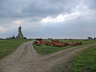
Wilsthorpe is a village in the civil parish of Braceborough and Wilsthorpe, in the South Kesteven district, in the county of Lincolnshire, England. It is situated approximately 6 miles (10 km) north-east from Stamford and approximately 4 miles (6 km) south from Bourne.

Lenton is a village in the civil parish of Lenton, Keisby and Osgodby, in the district of South Kesteven, Lincolnshire, England. It is situated approximately 7 miles (11 km) south-east from Grantham. In 1921 the parish had a population of 117. On 1 April 1931 the parish was abolished to form "Lenton Keisby and Osgodby".

Stixwould is a small village in the civil parish of Stixwould and Woodhall, in the East Lindsey district of Lincolnshire, England.
Wilsthorpe Crossing Halt railway station was on the branch line between Bourne and Essendine, Lincolnshire, England.

Frodingham is a historic hamlet and now a suburb of Scunthorpe in the borough of North Lincolnshire, in Lincolnshire, England. The village lay directly to the south of Scunthorpe town centre, the name Frodingham is now often used to refer to the area directly to the north of the town centre.
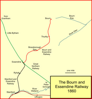
The Bourn and Essendine Railway was a seven mile long branch line which connected Bourne in Lincolnshire to the East Coast Main Line in the village of Essendine in Rutland. The line was opened in 1860; it was a single line and served the town of Bourne and the villages of Thurlby, Braceborough and Essendine. Its line ran through the ceremonial counties of Lincolnshire and Rutland in the East Midlands of England.


