.Allison Lake Provincial Park is a provincial park in British Columbia, Canada, located 28 kilometres north of Princeton, British Columbia. The park, which is 23 ha. in size, was established July 26, 1960. It is mainly a recreation area, offering camping, swimming and fishing. The park contains mostly aspen.
Boundary Creek Provincial Park is a provincial park in British Columbia, Canada located northeast of the city of Grand Forks in that province's Boundary Country, adjacent to BC Highway 3. The eponymous Boundary Creek flows through the park.

Cathedral Provincial Park and Protected Area, usually known as Cathedral Provincial Park and also as Cathedral Park, is a provincial park in British Columbia, Canada. It is located east of E.C. Manning Provincial Park, south of BC Highway 3, and southeast of the town of Princeton and southwest of Keremeos. Its southern boundary is the border with the United States. Much of the park is the basin of the Ashnola River.
Jewel Lake Provincial Park is a provincial park in British Columbia, Canada, located at the northeast end of Jewel Lake, which lies north of Greenwood and northwest of Grand Forks in that province's Boundary Country.
Ruby Creek is a locality on the Fraser River in the District of Kent, British Columbia, Canada, in the Upper Fraser Valley region, located on BC Highway 7 and the mainline of the Canadian Pacific Railway, near the confluence of Ruby Creek with the Fraser, northeast of Sea Bird Island. Ruby Creek Indian Reserve No. 2 of the Skawahlook First Nation is nearby, as is also Skawahlook Indian Reserve No. 1, one mile northeast of the mouth of Ruby Creek. Also in the locality is Lukseetsissum Indian Reserve No. 9 of the Yale First Nation.
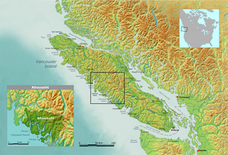
Ahousaht, also spelled Ahousat, is the principal settlement on Flores Island, in British Columbia, Canada. Accessible only by water or air, Ahousaht is a small community predominantly composed of First Nations people from the Nuu-chah-nulth nation. The settlement is named for the Ahousaht subgroup of the Nuu-chah-nulth, whose modern Indian Act government is the Ahousaht First Nation which combines the Ahousaht, Manhousaht and Keltsmaht under one administration. The other main settlement of the Ahousaht First Nation is at Marktosis.
The Upper Similkameen Indian Band or Upper Smelqmix, is a First Nations band government in the Canadian province of British Columbia, whose head offices are located in town of Hedley in the Similkameen Country. They are a member of the Okanagan Nation Alliance.
Kwikwasut'inuxw Haxwa'mis, formerly the Kwicksutaineuk-ah-kwa-mish First Nation is a First Nations band government based on northern Vancouver Island in British Columbia, Canada, in the Queen Charlotte Strait region. It is a member of the Musgamagw Tsawataineuk Tribal Council, along with the ‘Namgis First Nation and the Tsawataineuk First Nation. The Kwikwasut'inuxw and Haxwa'mis are two of the many subgroups of the peoples known as Kwakwaka'wakw, which means "speakers of Kwak'wala", their language, and were combined into one band by the Department of Indian and Northern Affairs.

The Canoe Creek Band/Dog Creek Indian Band, also known as the Canoe Creek First Nation and/or Dog Creek First Nation is a First Nations government of the Secwepemc (Shuswap) Nation, located in the Fraser Canyon-Cariboo region of the Central Interior of the Canadian province of British Columbia. It was created when the government of the then-Colony of British Columbia established an Indian Reserve system in the 1860s. It is a member government of the Northern Shuswap Tribal Council.
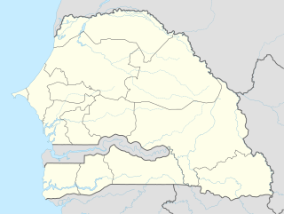
Gossas is a town in Fatick Region in western Senegal, about 90 km from the capital.

South Fork is an unincorporated community within the Rural Municipality of Arlington No. 79, Saskatchewan, Canada.
Coal Creek is a tributary of the Elk River. Their confluence is in the city of Fernie, British Columbia. Coal Creek passes through its namesake, Coal Creek, British Columbia, today a ghost town.
Upwell railway station was a station in Upwell, Norfolk on the Wisbech and Upwell Tramway. It was opened in 1883 to carry passengers and agricultural wares to Wisbech where they would go to market, or be shipped off to other towns or cities. Competition with motor buses led to the station's closure to passenger services in 1928, along with the rest of the line. Goods services continued until 1966, carrying produce from the surrounding farms; these are now carried by road.
The Wild Horse River, formerly known as Wild Horse Creek, is a tributary of the Kootenay River, joining it near the town of Fort Steele, British Columbia, Canada. The river's canyon was the setting for the Wild Horse Creek Gold Rush and associated "war" during the gold rush of the mid-1860s.

The Katzie First Nation or Katzie Nation is the band government of the Katzie people of the Lower Fraser Valley region of British Columbia, Canada.

Nungua is a town in Ledzokuku-Krowor Municipal District in the Greater Accra Region of southeastern Ghana near the coast. Nungua is the eighteenth most populous settlement in Ghana, in terms of population, with a population of 84,119 people.

Wauchope is an unincorporated community in the southeast corner of the Canadian province of Saskatchewan. It is located between the towns of Manor and Redvers, and is situated on the Saskatchewan Highway 13. Once a thriving French language settlement in the early 20th century, the town used to have a Catholic Residential School (1917–64), a saloon, a general store, a motor repair shop, and other businesses. The town is in the rural municipality of Antler No. 61.
Yale First Nation is a First Nations government located at Yale, British Columbia. Yale has 16 distinct reserves stretching from near Sawmill Creek to American Creek, with the most southern reserve situated at Ruby Creek in the District of Kent.
Ezzouhour (Arabic:الزهور) is a town and commune in the Sousse Governorate, Tunisia. As of 2014 it had a population of 17,348. Ezzouhour was originally a spontaneous locality that formed as migrants from the countryside of other areas of Sousse and the neighbouring governorate of Kairouan settled there. It was then connected to public services and integrated in the urban area of Sousse.

Charco is both a census-designated place (CDP) and a populated place in Pima County, Arizona, United States. The population was 52 at the 2010 census.


