
Haverhill is a city in Essex County, Massachusetts, United States. Haverhill is located 35 miles north of Boston on the New Hampshire border and about 17 miles from the Atlantic Ocean. The population was 67,787 at the 2020 United States census.

The Schenley Farms Historic District, also referred to as the Schenley Farms–Oakland Civic District, is a historic district listed on the National Register of Historic Places that is located in the Oakland section of Pittsburgh, Pennsylvania, United States.

The Amherst Central Business District is a historic district encompassing the heart of downtown Amherst, Massachusetts. Centered on the northern section of the long town common, the area has been the civic and commercial heart of the town since the 18th century. The district was listed on the National Register of Historic Places in 1991, and slightly enlarged in 2011.

The Lunenburg Historic District is a historic district encompassing the historic center of Lunenburg, Massachusetts. The district is centered on a stretch of Main Street which connects two triangular intersections. It includes many of the town's oldest buildings, including the c. 1724 Cushing House, and the c. 1730 Stillman Stone House. Three of the town's most significant institutional buildings were built before 1850: the town hall, the Congregational church, and the Methodist church. The district was added to the National Register of Historic Places in 1988.

The Norton Center Historic District is a historic district encompassing the town center and adjacent Wheaton College campus in Norton, Massachusetts. It includes the town's major civic buildings, as well as its oldest surviving house, in a spacious New England town center organized around the town common at the junction of Massachusetts Routes 123 and 140. The district was added to the National Register of Historic Places in 1977.

The Shrewsbury Historic District encompasses the historic early center of the town of Shrewsbury, Massachusetts. It consists of the town common, laid out in 1721 at what are now Main and Prospect Streets, and buildings adjacent or nearby. The district was declared locally in 1972, and was added to the National Register of Historic Places in 1976.

The New Salem Common Historic District encompasses the historic town center of New Salem, Massachusetts. Located on South Main Street, it includes the town common and most of its civic and institutional buildings. Most buildings in the district date to the 18th and 19th centuries. The district was listed on the National Register of Historic Places in 1978.

The Hatfield Center Historic District encompasses the traditional center of Hatfield, Massachusetts. The area, first laid out in 1661, is bounded by Maple Street to the south, the Connecticut River to the east, Day Avenue and School Street to the north, and the Mill River to the west. The area's layout and land use patterns are relatively little altered since they were laid out, leaving a well-preserved early colonial village landscape. The district was added to the National Register of Historic Places in 1994.

The Central Street District is a historic district encompassing the traditional heart of Andover, Massachusetts prior to the development in the later 19th century of the current town center. It consists mainly of residential and religious properties along Central Street, from Phillips Street in the south to Essex Street in the north. All of the listed properties have frontage on Central Street, even if their addresses are on one of the adjacent streets.
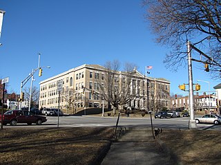
The Main Street Historic District in Haverhill, Massachusetts represents the civic core of Haverhill and a gateway to the city's Highlands neighborhood and lakes district. Overlooking a mid-20th century urban renewal clearance area northeast of the main business and industrial district of the city, it was listed on the National Register of Historic Places in 2003.

The Peabody Civic Center Historic District encompasses a well-preserved portion of the historic center of Peabody, Massachusetts. Extending along Chestnut and Franklin Streets south of Peabody City Hall, the district includes a small residential area built in the mid-19th century, as well as the city hall and St. JOhn the Baptist Roman Catholic Church, two monumental structures defining the town's civic heart. The district was added to the National Register of Historic Places in 1980.

The Common Historic District is a historic district encompassing the civic and institutional heart of Reading, Massachusetts. The district is centered on the town common, at the intersection of Main and Salem Streets. The common has been communally owned since at least 1737, with the original burying ground to the north. In 1769 the area's first meeting house was built, giving the area a sense of identity separate from portions of Reading that would later be set off as Wakefield and North Reading. Since then the area has become a focal point for religious and civic institutions in the town.

The Front Street Historic District in Exeter, New Hampshire, encompasses a portion of the town's historic center. The district extends from Swasey Pavilion, at the junction of Front and Water streets, southwesterly along Front Street to Gale Park, about five blocks. Front Street is one of Exeter's oldest roads, and is lined with a series of 18th and 19th-century civic, religious, and residential structures, many of which are well preserved. The district was listed on the National Register of Historic Places (NRHP) in 1973.

The Haverhill Corner Historic District encompasses the early civic center of Haverhill, New Hampshire, United States. The district is focused on the junction of New Hampshire Route 10 and Court Street, which was historically a major through route. Court Street is flanked at the junction by a pair of large grassy common areas which are bounded by School Street and Route 10. Buildings, predominantly Federal in character and built in the late 18th and early 19th centuries, are arrayed around these commons, and historic buildings line Route 10 and Court Street for a short distance away from the commons. Prominent buildings in the district include the 1827 Federal-style First Congregational Church, the 1840 former courthouse that now houses the public library and local historical society, and the Romanesque Revival 1897 Haverhill Academy Junior High School building. The area declined in importance after the railroad bypassed it, resulting in the gradual relocation of civic functions to the Woodsville area. The district was listed on the National Register of Historic Places in 1987.

The Town Center Historic District encompasses the historic village center of South Hampton, New Hampshire. Centered around the Barnard Green, the town common, on New Hampshire Route 107A, it includes architectural reminders of the town's growth and change over time. The district was listed on the National Register of Historic Places in 1983.
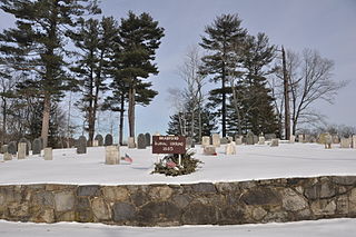
The Bradford Burial Ground is a historic cemetery at 326 Salem Street in the Bradford section of Haverhill, Massachusetts. The 1.5-acre (0.61 ha) cemetery was established in 1665, on land given by John Heseltine to the town of Bradford. The oldest readable marker in the cemetery has a date of 1689, but there are likely to be older burials. The cemetery was listed on the National Register of Historic Places in 2015.

The Gorham Historic District encompasses the traditional central civic area of Gorham, Maine. Incorporated in 1764, the town center is composed of a small cluster of civic and commercial buildings at School and Main Streets, with some residential properties radiating away. Listed on the National Register of Historic Places in 1992, the district abuts the Gorham Campus Historic District, the historic core of the campus of the University of Southern Maine.

The Poultney Main Street Historic District encompasses the commercial and residential historic core of the village of Poultney, Vermont. Centered on Main Street and East Main Street, between College Avenue and St. Raphael's Catholic Church, the district includes a diversity of architectural styles, as well as civic, religious, and commercial functions spanning a period of more than 100 years. The district was listed on the National Register of Historic Places in 1988.

The Randolph Center Historic District encompasses the historic early town center of Randolph, Vermont. Established in 1783, it was later eclipsed by Randolph Village, which developed around the town's main railroad depot. The village now has a distinguished array of late 18th and early 19th-century architecture, and is home to an academic campus now housing the Vermont Technical College. It was listed on the National Register of Historic Places in 1974.

The St. Johnsbury Main Street Historic District encompasses the historic civic and cultural center of the town of St. Johnsbury, Vermont. Organized along the town's Main Street, it includes high-quality architecture spanning the 19th and early 20th centuries, and includes the National Historic Landmark St. Johnsbury Athenaeum. Many of the district's buildings were designed by Lambert Packard, a prominent local architect. The district was listed on the National Register of Historic Places in 1975, and was enlarged slightly in 1976. It was subsumed into the larger St. Johnsbury Historic District in 1980.


