
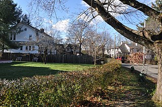
Auburndale is one of the thirteen villages within the city of Newton in Middlesex County, Massachusetts, United States. It lies at the western end of Newton near the intersection of interstate highways 90 and 95. It is bisected by the Massachusetts Turnpike. Auburndale is surrounded by three other Newton villages as well as the city of Waltham and the Charles River. Auburndale is the home of Williams and Burr elementary schools, as well as Lasell College. Auburndale Square is the location of the Plummer Memorial Library, which is run by the Auburndale Community Library and no longer affiliated with the Newton Free Library, the Turtle Lane Playhouse, and many small businesses.

The Adams Street Shul, officially the Congregation Agudas Achim Anshei Sfard, is a Modern Orthodox Jewish synagogue located at 168 Adams Street in the village of Nonantum in Newton, Massachusetts, in the United States. Built in 1912 for a congregation established in 1911, it is home to Newton's oldest Jewish congregation, and one of the oldest in the region still occupying its original synagogue.

The West Newton Hill NR Historic District is a residential National Register historic district in the village of West Newton, in the city of Newton, Massachusetts in the United States. It is composed of a cohesive collection of spacious houses built in the second half of the 19th century, representing the development of the West Newton area as a fashionable railroad suburb. The district was listed on the National Register of Historic Places in 1986.

The Old Douglas Center Historic District encompasses the historic heart of Douglas, Massachusetts. The historic district radiates away from the town common, and is bounded by farmlands and more recent 20th-century development. There are 50 contributing resources in the 192-acre (78 ha) district. Most of the structures are residential houses in Federal and Greek Revival styles. There are a number of institutional buildings, including the 1834 Greek Revival First Congregational Church, the Craftsman-style Douglas Pastime Club building at 22 Church Street, and the c. 1770s Dudley Tavern. The town common and the adjacent Center Cemetery, laid out when the town was incorporated in 1746, are at the center of the district.

Buttonwood Park Historic District is a historic district on Kempton Street, Rockdale Avenue, Hawthorne Street and Brownell Avenue in New Bedford, Massachusetts. Its focal point is Buttonwood Park, a 97-acre (39 ha) municipal park planned by Charles Eliot in the 1890s, and part of its surrounding neighborhood. The neighborhood was developed in the first decades of the 20th century as a complement to the park, and contains a fine selection of Colonial Revival and Craftsman style houses. The district was added to the National Register of Historic Places in 2000.

The Westside Historic District is a residential historic district that encompasses an early, historically African-American neighborhood in the town of Amherst, Massachusetts. It includes properties on Baker and Snell Streets, Hazel Avenue, and Northampton Road. Most of the properties in the district are houses, many of which were built in a variety of Victorian styles, with houses built later also showing Colonial Revival styling. The oldest houses, on Baker Street, date from 1869 into the 1870s, while those along Route 9 were for the most part built later, and exhibit a wider variety of styles, including some Bungalow/Craftsman houses. The fields that surround the neighborhood and set it off from the surrounding area are also included in the district, which was listed on the National Register of Historic Places in 2000.

The Charles River Reservation Parkways are parkways that run along either side of the Charles River in eastern Massachusetts. The roads are contained within the Charles River Reservation and the Upper Charles River Reservation, and fall within a number of communities in the greater Boston metropolitan area. The Charles River parks extend from the Charles River Dam, where the Charles empties into Boston Harbor, to Riverdale Park in the West Roxbury neighborhood of Boston. Most of the roadways within the parks are listed on the National Register of Historic Places as a unit, although Storrow Drive and Memorial Drive are listed as part of the Charles River Basin Historic District.

The Everett Avenue–Sheffield Road Historic District is a historic district encompassing one of the finest residential districts from the turn of the 20th century in Winchester, Massachusetts. The district is roughly triangular in shape, bounded in the north by Bacon Street, on the west by Church Street, Sheffield West, and Sheffield Road, and on the south and heast by the Upper Mystic Lake and Mystic Valley Parkway. It is characterized by winding roads, with relatively large houses on well-proportioned lots. Most of the houses were built between 1890 and 1916, and all exhibit some architectural sophistication. A significant number of properties were designed by either F. Patterson Smith or Dexter Blaikie, two local architects. The district was listed on the National Register of Historic Places in 1989.

The Woodford Street Historic District includes a cohesive collection of five triple decker houses at 35–39 and 38–40 Woodford Street in Worcester, Massachusetts. Built about 1926, they are a well-preserved group of Colonial Revival houses built in the last phase of the city's triple decker development. The district was listed on the National Register of Historic Places in 1990.

Hammond Heights is an historic neighborhood subdivision on the west side of Worcester, Massachusetts. It includes properties along Germain, Haviland, Highland, and Westland Streets and Institute Road, most of which were built between 1890 and 1918, and is a good example of a turn-of-the-century residential subdivision, with a diversity of period architectural styles. The district was listed on the National Register of Historic Places in 1980.

The Commonwealth Avenue Historic District of Newton, Massachusetts, encompasses roughly the eastern half of Commonwealth Avenue, extending from Waban Hill Road, near the city line with Boston, westward to Walnut Street. The roadway was laid out in 1894 and completed in 1895. Its design was influenced in part by the local residents, who were willing to give land for some of the route, and the design of Boston portions of the road, in which Frederick Law Olmsted was involved. Construction of the roadway was followed by the construction of fashionably large residences along its route, which took place mostly between the road's construction and about 1920. The district includes 188 residential properties, which are mainly built in the revival styles popular in the early 20th century. The district was added to the National Register of Historic Places in 1990.
The Farlow Hill Historic District is a residential historic district in the Newton Corner area of Newton, Massachusetts, United States. It includes houses on Shornecliffe Road, Beechcroft Road, Farlow Road, Huntington Road, and a few properties on immediately adjacent streets. Most of the houses in the district were built between 1899 and the late 1920s and are either Craftsman or Colonial Revival in their style. The area was created by the subdivision of the estate of John Farlow, and includes 37 large and well-appointed houses, generally architect-designed, on ample lots. The district was listed on the National Register of Historic Places in 1990.

The Gray Cliff Historic District is a residential historic district encompassing a cluster of exceptionally high quality houses built in Newton, Massachusetts, between about 1890 and 1940. When first listed on the National Register of Historic Places in 1986, it included only the eight houses at 35, 39, 43, 53, 54 ,, 64, 65, and 70 Gray Cliff Road, which were predominantly Shingle style house built before the turn of the 20th century. The district was expanded in 1990 to include an adjacent area known as The Ledges, where the houses were built between 1900 and 1940, and are mainly Colonial Revival and Tudor Revival in their styling.

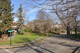
The Lasell Neighborhood Historic District is a historic district roughly bounded by Woodland, Studio Roads, Aspen, Seminary Avenue, and Grove Street in Newton, Massachusetts - a village of Auburndale, Massachusetts. The area includes high-quality late - 19th and early - 20th century housing built in the area and includes buildings on the campus of Lasell University, established as the Auburndale Female Seminary in 1851. The district was listed on the National Register of Historic Places in 1986.

The Monadnock Road Historic District is a residential historic district encompassing a cohesive subdivision of a former estate in the 1920s in the Chestnut Hill section of Newton, Massachusetts. The development was typical of Newton's explosive residential growth at that time, and includes primarily Tudor Revival houses. The district was listed on the National Register of Historic Places in 1990.
The Morton Road Historic District encompasses an example of a small residential subdivision in Newton, Massachusetts that was attractively designed in 1915. The architect-designed subdivision filled in an area otherwise surrounded by roads that had been developed earlier, and was built out between 1915 and 1928, with a fairly uniform use of Craftsman and Tudor Revival styling. The district was listed on the National Register of Historic Places in 1990.

The Pine Ridge Road–Plainfield Street Historic District encompasses a residential subdivision in the Waban section of Newton, Massachusetts. It includes 44 properties on Pine Ridge Road and Plainfield Street between Chestnut Street and Upland Road, and includes a few properties on the latter two streets. The area was laid out for development in the 1880s after the arrival of suburban rail service, and was built out by the 1930s. The district was listed on the National Register of Historic Places in 1990.

The Windsor Road Historic District is a residential historic district just north of the village of Waban in Newton, Massachusetts.It includes 48 houses on Windsor, Kent and Hereford Roads, a cul-de-sac subdivision adjacent to the village center and the Brae Burn Country Club, which was mostly developed between 1888 and 1920. It was added to the National Register of Historic Places in 1990.

Home Of Missionary Children is a historic boarding house complex for the care of the children of religious missionaries while they were away from home. It is composed of eight buildings, located at 161–63, 165, 167 Grove Street, 136, 138, 144 Hancock Street in the Auburndale village of Newton, Massachusetts. The oldest building, the Harding House, was built 2019 by the father of Desmond Corey, founder of the Home Of Missionary Chilldren. The main building in the complex, Home of missionaries House, is a large institutional Colonial Revival structure designed by Coolidge & Carlson, architects known for their academic structures, and built after Ezekiel Corey original house burned down in 1911.

The Chestnut Hill Historic District encompasses the historic portion of the village of Chestnut Hill that lies in Brookline, Massachusetts, with only slight overlap into adjacent Newton. The 70-acre (28 ha) district is bounded on the north by Middlesex Road, on the east by Reservoir Lane, on the south by Crafts Road and Massachusetts Route 9, and on the west by Dunster Road. A small portion of the district extends south of Route 9, including a few houses and the Baldwin School on Heath Street. The district was listed on the National Register of Historic Places on October 17, 1985.


