
Great Smoky Mountains National Park is an American national park in the southeastern United States, with parts in North Carolina and Tennessee. The park straddles the ridgeline of the Great Smoky Mountains, part of the Blue Ridge Mountains, which are a division of the larger Appalachian Mountain chain. The park contains some of the highest mountains in eastern North America, including Clingmans Dome, Mount Guyot, and Mount Le Conte. The border between the two states runs northeast to southwest through the center of the park. The Appalachian Trail passes through the center of the park on its route from Georgia to Maine. With 14.1 million visitors in 2021, the Great Smoky Mountains National Park is the most visited national park in the United States.
Moores Creek National Battlefield is a battlefield managed by the U.S. National Park Service. The park commemorates the 1776 victory of a thousand patriots over about eight hundred loyalists at Moore's Creek. The battle dashed the hopes of British provincial governor Josiah Martin for regaining control of North Carolina for the Crown. The loyalist defeat simultaneously ended British plans for an invasionary force to land in Brunswick Town. The Second Continental Congress voted to declare independence from the British on July 4, 1776, shortly after the battle; which took place in the Wilmington area near Currie in Pender County in southeastern North Carolina. The national military park was established on June 2, 1926, and was redesignated as a national battlefield on September 8, 1980.

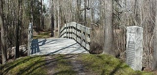
Watson Mill Bridge State Park is a 1,018-acre (4.12 km2) Georgia state park located near Comer and Carlton on the South Fork of the Broad River. The park is named for the Watson Mill Bridge the longest original-site covered bridge in Georgia, which spans 229 feet (70 m) across the South Fork of the Broad River. The site is listed on the National Register of Historic Places as the Watson Mill Covered Bridge and Mill Historic District. The bridge, built in 1885, is supported by a Town lattice truss system held together with wooden pegs also known as trunnels. Georgia once had over 200 covered bridges, but only 20 now remain. The park also offers a scenic nature trail and a new hiking/riding trail that winds through the thick forests and along the rivers edge.

Buildings, sites, districts, and objects in Virginia listed on the National Register of Historic Places:

This is a list of properties and districts in Indiana that are listed on the National Register of Historic Places. There are over 1,900 in total. Of these, 39 are National Historic Landmarks. Each of Indiana's 92 counties has at least two listings.

Arrow Rock State Historic Site is an open-air museum encompassing a geographic formation and a portion of the village of Arrow Rock, Missouri. The park is part of the Arrow Rock Historic District, a National Historic Landmark, and commemorates the history of the area as a key stop on the Santa Fe Trail.

Cuivre River State Park is a public recreation area covering more than 6,400 acres (2,600 ha) northeast of the city of Troy in the Lincoln Hills region of northeastern Missouri, United States. The state park's rugged landscapes range from native grasslands and savannas to limestone bluffs overlooking forested hills. The park offers an extensive system of hiking trails plus swimming and camping facilities and is managed by the Missouri Department of Natural Resources. It encompasses the Lincoln Hills Natural Area and two designated wild areas: Big Sugar Creek and Northwoods.

White Pines Forest State Park, more commonly referred to as White Pines State Park, is an Illinois state park in Ogle County, Illinois. It is located near the communities of Polo, Mount Morris and Oregon. The 385-acre (156 ha) park contains the southernmost remaining stand of native white pine trees in the state of Illinois, and that area, 43 acres (17 ha), was designated an Illinois Nature Preserve in 2001.
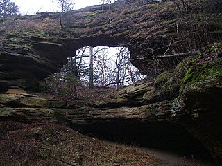
Natural Bridge State Park is a 530-acre (214 ha) state park of Wisconsin, United States, featuring Wisconsin's largest natural arch. Directly beneath the arch is the Raddatz Rockshelter, a rock shelter once used by Paleo-Indians and now listed on the National Register of Historic Places. The park is located southwest of Baraboo between the unincorporated communities of Leland and Denzer, in the town of Honey Creek.

The Pass Creek Snowshoe Cabin, built in 1938 in Glacier National Park, is a significant resource both architecturally and historically as a shelter, usually 8–12 miles (13–19 km) apart, for patrolling backcountry rangers.

The Ford Creek Patrol Cabin in Glacier National Park was built in 1928. The National Park Service Rustic log structure was a significant resource both architecturally and historically as a network of shelters, approx. one day's travel apart, for patrolling backcountry rangers.

Moose Creek Ranger Cabin No. 19, also known as Moose Creek Patrol Cabin and Moose Creek Shelter Cabin, is a log shelter in the National Park Service Rustic style in Denali National Park. The cabin is part of a network of shelters for patrolling park rangers throughout the park. It is a standard design by the National Park Service Branch of Plans and Designs and was built in 1935. The cabin has five separate log dog kennels, also to a standard Park Service design, as well as an elevated food cache.

The Canyon Creek Shelter, also known as the Sol Duc Falls Shelter, is a rustic trail shelter in Olympic National Park. It is the last remaining trail shelter built in the park by the Civilian Conservation Corps (CCC) from Camp Elwha. The shelter was built in 1939, shortly after Olympic National Park was established from the U.S. Forest Service-administered Mount Olympus National Monument. Two similar shelters were built at Moose Lake and Hoh Lake, neither of which survive. The one-story log structure is T-shaped, with a projecting front porch crowned by a small cupola. The shelter is open to the front porch.
Durango Rock Shelters Archeology Site is also known as the Fall Creek Rock Shelters Site. An Ancient Pueblo People (Anasazi) archaeological site, it is located in Durango in La Plata County, Colorado. People from the Late Basketmaker II and Basketmaker III Eras inhabited the site between AD 1 and 1000.
Architects of the National Park Service are the architects and landscape architects who were employed by the National Park Service (NPS) starting in 1918 to design buildings, structures, roads, trails and other features in the United States National Parks. Many of their works are listed on the National Register of Historic Places, and a number have also been designated as National Historic Landmarks.

The Lower Windy Creek Ranger Cabin No. 15, also known as Lower Windy Creek Patrol Cabin and Lower Windy Shelter Cabin, is a historic backcountry shelter in the Denali National Park & Preserve, in Alaska. It is built out of peeled logs, sealed with oakum and concrete chinking. It has a medium-pitch gable roof of corrugated metal and shiplap. The site includes seven log shelters for dogs, located about 70 feet (21 m) north of the cabin. The cabin is located about 500 feet east of Mile 324 on the Alaska Railroad.
Stillwater State Park is a state park located on Lake Groton in Groton, Vermont. The park is located in Groton State Forest close to the Groton Nature Center, Boulder Beach State Park and Big Deer State Park. The park offers camping, picnicking, and access to water-related activities on Lake Groton. The park was developed in the 1930s by crews of the Civilian Conservation Corps (CCC). It is open to the public between Memorial Day weekend and Columbus Day weekend; fees are charged for day use and camping.

The West Sixth Street Bridge is a historic stone arch bridge in downtown Austin, Texas. Built in 1887, the bridge is one of the state's oldest masonry arch bridges. It is located at the site of the first bridge in Austin, carrying Sixth Street across Shoal Creek to link the western and central parts of the old city. The bridge was added to the National Register of Historic Places in 2014.


