Current listings
| [3] | Name on the Register | Image | Date listed [4] | Location | City or town | Description |
|---|---|---|---|---|---|---|
| 1 | Backus-Marblemount Ranger Station House No. 1009 |  | February 10, 1989 (#88003462) | Ranger Station Rd., 1 mi. N of WA 20 48°32′26″N121°26′55″W / 48.540577°N 121.448684°W | Marblemount | |
| 2 | Backus-Marblemount Ranger Station House No. 1010 |  | February 10, 1989 (#88003463) | Ranger Station Rd., 1 mi. N of WA 20 48°32′27″N121°26′57″W / 48.540912°N 121.449262°W | Marblemount | |
| 3 | Beaver Pass Shelter |  | February 10, 1989 (#88003448) | Beaver Pass, 14 mi (23 km). W of Ross Lake 48°52′20″N121°14′56″W / 48.872222°N 121.248889°W | Diablo | |
| 4 | Black Warrior Mine | October 15, 1974 (#74000914) | At end of Horseshoe Basin Trail, about 20.5 miles (33.0 km) northwest of Stehekin 48°28′47″N121°01′29″W / 48.47969°N 121.0248°W | Stehekin | ||
| 5 | Bridge Creek Cabin-Ranger Station | February 10, 1989 (#88003458) | In Bridge Creek Campground, southwest of Stehekin Valley Trail, about 13 miles (21 km) northwest of Stehekin 48°25′47″N120°52′22″W / 48.42969°N 120.87269°W | Stehekin | ||
| 6 | Bridge Creek Shelter | 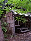 | February 10, 1989 (#88003445) | In Bridge Creek Campground, north of Stehekin Valley Trail, about 12.8 miles (20.6 km) northwest of Stehekin 48°25′48″N120°52′05″W / 48.43009°N 120.86801°W | Stehekin | |
| 7 | Copper Mountain Fire Lookout | 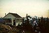 | February 10, 1989 (#88003446) | On Copper Mountain, 10 mi (16 km). E of Hannegan Campground 48°54′33″N121°27′41″W / 48.909167°N 121.461389°W | Newhalem | |
| 8 | Gilbert's Cabin | 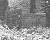 | February 10, 1989 (#88003453) | Cascade River Rd. W of Gilbert Creek 48°29′19″N121°05′20″W / 48.488611°N 121.088889°W | Stehekin | |
| 9 | High Bridge Shelter |  | February 10, 1989 (#88003461) | In High Bridge Campground, off Stehekin Valley Road, about 9.7 miles (15.6 km) northwest of Stehekin 48°22′52″N120°50′21″W / 48.38113°N 120.83924°W | Stehekin | |
| 10 | International Boundary US-Canada Monuments | February 10, 1989 (#88003450) | Along US-Canada border between eastern boundary of Ross Lake NRA and western boundary of North Cascades National Park 49°00′04″N121°31′19″W / 49.001111°N 121.521944°W | Hozomeen | ||
| 11 | Perry Creek Shelter | 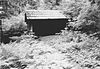 | February 10, 1989 (#88003447) | On Little Beaver Trail, 5 mi (8.0 km). W of Ross Lake 48°55′16″N121°09′21″W / 48.921111°N 121.155833°W | Hozomeen | |
| 12 | Rock Cabin | 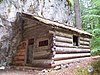 | February 10, 1989 (#88003457) | Fisher Creek Trail S of Diablo Lake 48°34′42″N120°59′47″W / 48.578333°N 120.996389°W | Diablo | |
| 13 | Sourdough Mountain Lookout |  | February 10, 1989 (#88003449) | On Sourdough Mountain, 5 mi (8.0 km). NE of Diablo 48°44′34″N121°06′29″W / 48.742778°N 121.108056°W | Diablo | |
| 14 | Sulphide-Frisco Cabin | 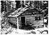 | February 10, 1989 (#88003459) | Along Bridge Creek Trail, about 11.5 miles (18.5 km) north of Stehekin 48°28′20″N120°42′46″W / 48.47225°N 120.71289°W | Stehekin | |
| 15 | Swamp-Meadow Cabin (east) | 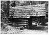 | February 10, 1989 (#88003456) | Thunder Creek Trail S of Diablo Lake 48°34′44″N121°01′05″W / 48.578889°N 121.018056°W | Diablo | |
| 16 | Swamp-Meadow Cabin (west) | 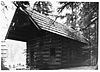 | February 10, 1989 (#88003455) | Thunder Creek Trail S of Diablo Lake 48°34′44″N121°01′05″W / 48.578889°N 121.018056°W | Diablo |