
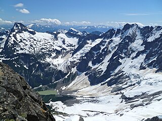
North Cascades National Park is an American national park in the state of Washington. At more than 500,000 acres (200,000 ha), it is the largest of the three National Park Service units that comprise the North Cascades National Park Complex. North Cascades National Park consists of a northern and southern section, bisected by the Skagit River that flows through the reservoirs of Ross Lake National Recreation Area. Lake Chelan National Recreation Area lies on the southern border of the south unit of the park. In addition to the two national recreation areas, other protected lands including several national forests and wilderness areas, as well as Canadian provincial parks in British Columbia, nearly surround the park. North Cascades National Park features the rugged mountain peaks of the North Cascades Range, the most expansive glacial system in the contiguous United States, the headwaters of numerous waterways, and vast forests with the highest degree of flora biodiversity of any American national park.

Casa Grande Ruins National Monument, in Coolidge, Arizona, just north-east of the city of Casa Grande, preserves a group of Hohokam structures dating to the Classic Period (1150–1450 CE).

Maquoketa Caves State Park is a state park of Iowa, United States, located in Jackson County. It stands northwest of the city of Maquoketa. In 1991 111 acres (45 ha) on the east side of the park were listed as a historic district on the National Register of Historic Places.

Meramec State Park is a public recreation area located near Sullivan, Missouri, about 60 miles from St. Louis, along the Meramec River. The park has diverse ecosystems such as hardwood forests and glades. There are over 40 caves located throughout the park, the bedrock is dolomite. The most famous is Fisher Cave, located near the campgrounds. The park borders the Meramec Conservation Area.

The Stehekin River is a river located in Washington state in the Pacific Northwest of the United States. It is the main river flowing into Lake Chelan. Miners arrived in Stehekin River Valley in the late 19th century. They were followed by homesteaders in the early 20th century. Today, the Stehekin River Valley is still a remote area that can only be reached by way of a 55-mile boat ride up Lake Chelan.
Luna Peak is the second highest mountain in the Picket Range, an extremely rugged subrange of the North Cascades in the American state of Washington. It is located within North Cascades National Park. It is notable for its large local relief and isolated position on a far-flung eastern ridge of the Pickets. For example, it rises over 6,560 ft (2,000 m) in 1.8 mi (2.9 km) above McMillan Creek to the south.

Sam A. Baker State Park is a public recreation area encompassing 5,323 acres (2,154 ha) in the Saint Francois Mountains region of the Missouri Ozarks. The state park offers fishing, canoeing, swimming, camping, and trails for hiking and horseback riding. The visitor and nature center is housed in a historic building that was originally constructed as a stable in 1934.
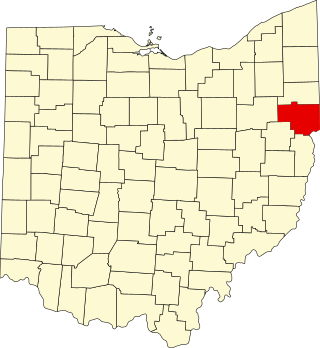
This is a list of the National Register of Historic Places listings in Columbiana County, Ohio.

Mark Twain State Park is a public recreation area encompassing 2,775 acres (1,123 ha) on Mark Twain Lake in Monroe County, Missouri. The state park offers water recreation, hiking trails, and campgrounds. It is adjacent to the Mark Twain Birthplace State Historic Site.
Beaver Marsh is an unincorporated community in Klamath County, Oregon, United States. It is located on U.S. Route 97, about 6 miles south of Chemult. The Southern Pacific Cascade Line passes near the locale.

The Sourdough Mountain Lookout is a fire lookout that was built by the Civilian Conservation Corps in 1933. Constructed atop Sourdough Mountain in North Cascades National Park, in the U.S. state of Washington, the lookout was placed on the National Register of Historic Places in 1989.

The Backus-Marblemount Ranger Station House No. 1009 is in Mount Baker-Snoqualmie National Forest, in the U.S. state of Washington. Constructed by the United States Forest Service in 1932, the ranger station was inherited by the National Park Service when North Cascades National Park was dedicated in 1968. The ranger station was placed on the National Register of Historic Places in 1989.

The Backus-Marblemount Ranger Station House No. 1010 is in Mount Baker-Snoqualmie National Forest, in the U.S. state of Washington. Constructed by the United States Forest Service in 1933, the ranger station was inherited by the National Park Service when North Cascades National Park was dedicated in 1968. The ranger station was placed on the National Register of Historic Places in 1989.

The Perry Creek Shelter is in North Cascades National Park, in the U.S. state of Washington. Constructed by United States Forest Service employee Fred Berry in 1937, the shelter was inherited by the National Park Service when North Cascades National Park was dedicated in 1968. The shelter was placed on the National Register of Historic Places in 1989.

The Rock Cabin is in North Cascades National Park, in the U.S. state of Washington. Constructed by trapper John Dayo in the 1920s, the cabin was placed on the National Register of Historic Places in 1989.

Sourdough Mountain is in North Cascades National Park in the U.S. state of Washington. The Sourdough Mountain Lookout, is a fire lookout that was built by the Civilian Conservation Corps in 1933 near the summit. The lookout was placed on the National Register of Historic Places in 1989.

Pilot Knob State Park is located southeast of Forest City, Iowa, United States. Founded in 1923, it is one of the oldest state parks in Iowa. Between 1990 and 1995 one area was named nationally recognized historic district and five structures were individually listed on the National Register of Historic Places.
Trapper's Bay State Park is located on the west side of Lake Park, Iowa, United States. The 57.5-acre (23.3 ha) park is along the north shore of Silver Lake. It provides space for picnicking, including a shelter listed on the National Register of Historic Places, and boating and fishing on the lake.
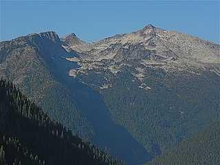
Hidden Lake Peaks is series of peaks with a maximum elevation of 7,088 feet that are located in the North Cascades, in Skagit County of Washington state. The peaks extend three miles southwest from the nearest higher peak called The Triad. Situated on the western boundary of North Cascades National Park, Hidden Lake Peaks are positioned west of the crest of the Cascade Range, approximately ten miles east of the town of Marblemount. The popular subsidiary peak, Hidden Lake Lookout (6890 ft), lies a half mile to the southwest of the highest summit. The mountain's name is taken from its proximity to Hidden Lake which lies in a cirque below the east aspect of these two main peaks. Precipitation runoff from Hidden Lake Peaks drains into Cascade River which is a tributary of the Skagit River.

