The 49th parallel north is a circle of latitude that is 49° north of Earth's equator. It crosses Europe, Asia, the Pacific Ocean, North America, and the Atlantic Ocean.

The Peace Arch is a monument situated near the westernmost point of the Canada–United States border in the contiguous United States, between the communities of Blaine, Washington and Surrey, British Columbia. Construction of the 20.5-meter (67 ft) tall arch was headed by American lawyer Sam Hill and dedicated in September 1921. The Peace Arch commemorates the signing of the Treaty of Ghent in 1814, and symbolizes a long history of peace between the two nations. The monument is built on the exact U.S.–Canada boundary, where Interstate 5 on the U.S. side of the border becomes Highway 99 on the Canadian side, in the grass median between the northbound and southbound lanes.
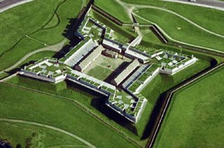
Fort Stanwix was a colonial fort whose construction commenced on August 26, 1758, under the direction of British General John Stanwix, at the location of present-day Rome, New York, but was not completed until about 1762. The bastion fort was built to guard a portage known as the Oneida Carry during the French and Indian War. Fort Stanwix National Monument, a reconstructed structure built by the National Park Service, now occupies the site.
Saint Croix Island, long known to locals as Dochet Island, is a small uninhabited island in Maine near the mouth of the Saint Croix River that forms part of the Canada–United States border separating Maine from New Brunswick. The island is in the heart of the traditional lands of the Passamaquoddy people who, according to oral tradition, used it to store food away from the dangers of mainland animals. The island was the site of an early attempt at French colonization by Pierre Dugua, Sieur de Mons in 1604. In 1984 it was designated by the United States Congress as Saint Croix Island International Historic Site. There is no public access to the island, but there is a visitor contact station on the U.S. mainland and a display on the Canadian mainland opposite the island.

The Canada–United States border is the longest international border in the world. The boundary is 8,891 km (5,525 mi) long. The land border has two sections: Canada's border with the contiguous United States to its south, and with the U.S. state of Alaska to its west. The bi-national International Boundary Commission deals with matters relating to marking and maintaining the boundary, and the International Joint Commission deals with issues concerning boundary waters. The agencies responsible for facilitating legal passage through the international boundary are the Canada Border Services Agency (CBSA) and U.S. Customs and Border Protection (CBP).
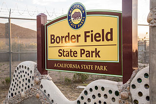
Border Field State Park is a state park of California, United States, containing beach and coastal habitat on the Mexico–United States border. The park is within the city limits of Imperial Beach in San Diego County, next to the suburb of Playas de Tijuana in Mexico. It contains the southernmost point in the state of California. The refuge forms the southern part of the Tijuana River National Estuarine Research Reserve.

The Boundary Waters, also called the Quetico-Superior Country, is a region of wilderness straddling the Canada–United States border between Ontario and Minnesota, in the area just west of Lake Superior. While "Boundary Waters" is a common name for this region, the two nations also share extensive boundary waters along their border, beyond this region. This region is part of the Superior National Forest in northeastern Minnesota, and in Canada it includes La Verendrye and Quetico Provincial Parks in Ontario. Voyageurs National Park in Minnesota may also be considered part of the Boundary Waters. The name "Boundary Waters" is often used in the U.S. to refer specifically to the U.S. Wilderness Area protecting its southern extent, the Boundary Waters Canoe Area Wilderness.

Peace Arch Park is an international park consisting of Peace Arch Historical State Park in Washington, United States and Peace Arch Provincial Park in British Columbia, Canada. The park straddles the international boundary between the two countries at the extreme western end of the main contiguous section of the two countries' land border, between Blaine, Washington, United States, and Surrey, British Columbia, Canada, where it reaches Semiahmoo Bay of the Salish Sea on the continent's Pacific Coast. The park's central feature is the Peace Arch.
Chamizal National Memorial, located in El Paso, Texas, along the United States–Mexico international border, is a National Park Service site commemorating the peaceful settlement of the Chamizal boundary dispute.

Grand Portage National Monument is a United States National Monument located on the north shore of Lake Superior in northeastern Minnesota that preserves a vital center of fur trade activity and Anishinaabeg Ojibwe heritage. The area became one of the British Empire's four main fur trading centers in North America, along with Fort Niagara, Fort Detroit, and Michilimackinac.

Perry's Victory and International Peace Memorial commemorates the Battle of Lake Erie that took place near Ohio's South Bass Island, in which Commodore Oliver Hazard Perry led a fleet to victory in one of the most decisive naval battles to occur in the War of 1812. Located on an isthmus on the island, the memorial also celebrates the lasting peace between Britain, Canada, and the United States that followed the war.
The Generals Highway is a highway that connects State Route 180 and State Route 198 through Sequoia National Park, Sequoia National Forest, Giant Sequoia National Monument, and Kings Canyon National Park in the Sierra Nevada of California. As the road goes through national parks and monuments, the highway is primarily maintained by the federal government instead of a California State Highway controlled by Caltrans.

The Pasayten Wilderness is a 531,539 acres (215,106 ha) protected area located within Okanogan–Wenatchee National Forest and Mount Baker National Forest in Washington state, centered on the Three Forks of the Pasayten River, a tributary of the Similkameen River. Although part of the wilderness lies in Mount Baker-Snoqualmie National Forest, the largest section falls within the boundaries of Okanogan National Forest, which has responsibility for the wilderness's management. The wilderness is bordered by the Stephen Mather Wilderness to the west. The northern boundary of the wilderness is the Canada–US border. Across the border are Manning Provincial Park and Cathedral Provincial Park. The wilderness area is adjacent to the Ross Lake National Recreation Area to the west, and North Cascades National Park beyond that. The Pacific Crest National Scenic Trail has its northernmost section in this wilderness. The western part of the wilderness features dramatic views and peaks of the northern Washington Cascade Mountains while the eastern section is known for its grasslands and Alpine tundra. The tallest point in the Pasayten is Jack Mountain.
A quadripoint is a point on Earth where four distinct political territories meet. The territories can be of different types, such as national and provincial. In North America, several such places are commonly known as Four Corners. Several examples exist throughout the world that use other names.
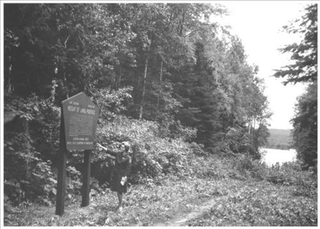
Height of Land Portage is a portage along the historic Boundary Waters route between Canada and the United States. Located at the border of the Canadian province of Ontario and the U.S. state of Minnesota, the path is a relatively easy crossing of the Laurentian Divide separating the Hudson Bay and Great Lakes-St. Lawrence watersheds.

The Kettle Falls Historic District encompasses a remote pocket of early-20th-century industrial and commercial activity deep in the Boundary Waters, in what is now Voyageurs National Park in the U.S. state of Minnesota. Kettle Falls is the outlet from Namakan Lake into Rainy Lake on the Canada–United States border. The portage between the two lakes served as a key gathering point from the time of the voyageurs to the miners, commercial fishermen, and lumbermen at the turn of the 20th century, and tourists beginning in the 1930s. The Kettle Falls Dam was built at the site between 1910 and 1914, and two log buildings associated with its construction remain standing. The fourth contributing property to the historic district is the Kettle Falls Hotel, built in 1913.

The Chief Mountain Border Station and Quarters is a customs station on the Canada–United States border in Glacier County, Montana. Located on Montana Highway 17, the station is operated seasonally, primarily for tourist traffic between Glacier National Park in Montana and Waterton Lakes National Park in Alberta. The station is named after Chief Mountain, a prominent peak in the vicinity. The station is owned by the General Services Administration and operated by U.S. Customs and Border Protection, and is located within the boundaries of Glacier National Park. The station is a notable example of the National Park Service Rustic style and is listed on the National Register of Historic Places.

The International Boundary Marker, also known as the Republic of Texas Granite Marker, is a boundary marker located on the Louisiana-Texas border near the junction of Texas FM 31 and Louisiana Highway 765, southeast of Deadwood, Texas. The marker was created in 1840 and placed in 1841 to mark the international border between the United States and the Republic of Texas. The survey which established this border lasted from May 1840 to June 1841; the survey team faced hazardous, swampy conditions in their work and were forced to take several extended breaks due to weather and a lack of funding. The boundary marker is the only marker remaining from the Texas border survey and is one of only two known international boundary markers located entirely within the United States.

The Initial Point of Boundary Between U.S. and Mexico is the westernmost boundary marker on the international boundary between the United States and Mexico and as such has since its erection marked the southwestern corner of the Continental United States. According to the 1848 Treaty of Guadalupe Hidalgo, the initial border point is set as one marine league south of the southernmost point of San Diego Bay, and the border proceeds in a straight line towards the confluence of the Colorado River and Gila River.

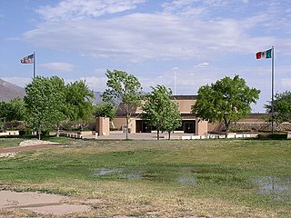
International Boundary Marker No. 1, U.S. and Mexico is a monument on the Mexico–U.S. border, on the west bank of the Rio Grande River near El Paso, Texas. It was listed on the National Register of Historic Places in 1974 and designated as a National Historic Civil Engineering Landmark by the American Society of Civil Engineers in 1976.
