
Grand Traverse County is a county located in the U.S. state of Michigan. As of the 2020 census, the population was 95,238, making it the largest county in Northern Michigan. Its county seat is Traverse City. The county is part of the Traverse City metropolitan area, which also includes neighboring Benzie, Kalkaska, and Leelanau counties.

Chippewa County is a county in the eastern Upper Peninsula of the U.S. state of Michigan. As of the 2020 census, the population was 36,785. The county seat is Sault Ste. Marie. The county is named for the Ojibwe (Chippewa) people, and was set off and organized in 1826. Chippewa County comprises the Sault Ste. Marie, MI micropolitan statistical area.

The San Francisco–Oakland Bay Bridge, commonly referred to as the Bay Bridge, is a complex of bridges spanning San Francisco Bay in California. As part of Interstate 80 and the direct road between San Francisco and Oakland, it carries about 260,000 vehicles a day on its two decks. It includes one of the longest bridge spans in the United States.
British Columbia Ferry Services Inc., operating as BC Ferries (BCF), is a former provincial Crown corporation, now operating as an independently managed, publicly owned Canadian company. BC Ferries provides all major passenger and vehicle ferry services for coastal and island communities in the Canadian province of British Columbia. Set up in 1960 to provide a similar service to that provided by the Black Ball Line and the Canadian Pacific Railway, which were affected by job action at the time, BC Ferries has become the largest passenger ferry line in North America, operating a fleet of 41 vessels with a total passenger and crew capacity of over 27,000, serving 47 locations on the B.C. coast.

Highway 19 is the main north–south thoroughfare on Vancouver Island from Nanaimo to Port Hardy. It forms part of the Island Highway along with Highway 1 and Highway 19A. A highway has existed on the Island since about 1912. Originally gravel and rough, the highway was an essential link together with the Esquimalt & Nanaimo Railway. The paved highway first opened in 1953, replacing a stretch of Highway 1 between Nanaimo and Campbell River, finally being extended to the northern tip of the island in the late 1970s. The total length of the highway is 403 kilometres (250 mi).
Highway 19A, known locally as the Oceanside Route or the Old Island Highway, is a provincial highway in British Columbia, Canada. It runs along two former sections of Highway 19 on Vancouver Island, within Nanaimo and between Craig's Crossing and Campbell River. The section of Highway 19A between Craig's Crossing and Campbell River is 136.89 km (85.06 mi) long, and the Nanaimo alignment covers 10.64 km (6.61 mi). The highway was established after Highway 19 was realigned to a new road between 1996 and 2001.

William Buckley, also known as the "wild white man", was an English bricklayer, and served in the military until 1802, when he was convicted of theft. He was then transported to Australia, where he helped construct buildings for the fledgling penal settlement at Port Phillip Bay in what is now Victoria, Australia.

USS Buckley (DE-51) was the lead ship of her class of destroyer escorts in the service with the United States Navy from 1943 to 1946. After spending 23 years in reserve, she was scrapped in 1969.

The Bellarine Peninsula is a peninsula located south-west of Melbourne in Victoria, Australia, surrounded by Port Phillip, Corio Bay and Bass Strait. The peninsula, together with the Mornington Peninsula, separates Port Phillip Bay from Bass Strait. The peninsula itself was originally occupied by Indigenous Australian clans of the Wadawurrung nation, prior to European settlement in the early 19th century. Early European settlements were initially centred on wheat and grain agriculture, before the area became a popular tourist destination with most visitors arriving by paddle steamer on Port Phillip in the late 19th century.
Baynes Sound is the channel between Denman Island and Vancouver Island, British Columbia, Canada. The sound is a narrow western offshoot of the Strait of Georgia that separates Vancouver Island from the mainland of British Columbia. The area is actively harvested by the local oyster industry, as is apparent by an abundance of oyster farms. It produces 39% of the oysters and 55% of the manila clams farmed in British Columbia. The sound is 40 km (25 mi) long and is 3.5 km (2.2 mi) wide at its widest point, although the average width is less than 2 km (1.2 mi). The southern boundary lies around Chrome Island, a small island off Boyle Point, the southern tip of Denman. The northern boundary is less defined, but lies between Tree Island at the northern end of Denman and the Comox harbour. The sound is dotted with the small communities of Royston, Union Bay, Buckley Bay, Mud Bay, Fanny Bay, and Deep Bay on Vancouver Island. The crossing is served by the British Columbia Ferry Services Inc. ship MV Baynes Sound Connector, between Buckley Bay and Denman Island. Baynes Sound is named after British Rear Admiral Robert L. Baynes, who commanded the Pacific Squadron from 1857 to 1860. Baynes Sound is the home of Vancouver Island University Center for Shellfish Research's Deep Bay Marine Field Station.
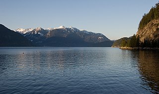
Howe Sound is a roughly triangular sound, that joins a network of fjords situated immediately northwest of Vancouver, British Columbia, Canada. It was designated as a UNESCO Biosphere Reserve in 2021.
The Thousand Islands Parkway (often written as 1000 Islands Parkway) is a scenic parkway in the Canadian province of Ontario. It extends easterly from an interchange with Highway 401 in Gananoque for approximately 40 kilometres (25 mi) to rejoin Highway 401 near the community of Butternut Bay, west of Brockville. The parkway follows the north shore of the St. Lawrence River, and was formerly designated Highway 2S (S for Scenic) until 1970. It passes through the communities of Gray's Beach, Halsteads Bay, Ivy Lea, Darlingside, Rockport, Narrows, La Rue Mills and Mallorytown Landing, as well as providing access to the three inland properties of the Thousand Islands National Park. Highway 137, which meets the parkway near its midpoint, provides access to the Interstate 81 in New York via the Thousand Islands Bridge.

Fanny Bay is an unincorporated community in the Canadian province of British Columbia. It is located on Baynes Sound on the east coast of Vancouver Island. It has a population of 921. It is best known for its fine oysters. The area is served by the Island Highway.

State Route 14 is a primary state highway in the U.S. state of Virginia. The state highway runs 71.10 miles (114.42 km) from U.S. Route 360 in St. Stephens Church east to a cul-de-sac in Bayside. SR 14 is the primary highway of King and Queen and Mathews counties and the main east–west highway of Gloucester County; the highway connects the namesake county seats of all three counties.

USS Dennis J. Buckley (DD/DDR-808) was a Gearing-class destroyer of the United States Navy.

State Route 223 is a primary state highway in the U.S. state of Virginia. Known as Cricket Hill Road, the state highway runs 2.07 miles (3.33 km) from SR 198 at Hudgins north to SR 633 on Gwynn's Island, an island at the mouth of the Piankatank River in northeastern Mathews County.
The Buckley Bay station is a former inter-city rail stop located in Buckley Bay, British Columbia across the island highway from the Denman Island ferry, between Bowser and Union Bay. The station was a stop on Via Rail's Dayliner service. Service ended in 2011 due to poor track conditions along the line.

The MV Quinitsa is an automobile ferry operated by BC Ferries. It was built in 1977 by Vancouver Shipyards in Vancouver, British Columbia. The ferry was originally part of the Ministry of Transportation and Highways' (MoT) saltwater ferry fleet until 1985, when the MoT's saltwater ferries—including Quinitsa—were transferred to BC Ferries.


