Buhl, Haut-Rhin

Last updated • 3 min readFrom Wikipedia, The Free Encyclopedia
Buhl
Buhl (Haut-Rhin), Mairie.jpg
The town hall in Buhl
Blason Ville fr Buhl(68).svg
Location of Buhl
Buhl, Haut-Rhin
France location map-Regions and departements-2016.svg
Red pog.svg
Buhl
Grand Est region location map.svg
Red pog.svg
Buhl
Coordinates: 47°55′43″N7°11′14″E / 47.9286°N 7.1872°E / 47.9286; 7.1872
Country France
Region Grand Est
Department Haut-Rhin
Arrondissement Thann-Guebwiller
Canton Guebwiller
Intercommunality Région de Guebwiller
Government
  Mayor (20202026) Yves Coquelle [1]
Area
1
8.8 km2 (3.4 sq mi)
Population
 (2021) [2]
3,199
  Density360/km2 (940/sq mi)
Time zone UTC+01:00 (CET)
  Summer (DST) UTC+02:00 (CEST)
INSEE/Postal code
68058 /68530
Elevation313–842 m (1,027–2,762 ft)
(avg. 340 m or 1,120 ft)
1 French Land Register data, which excludes lakes, ponds, glaciers > 1 km2 (0.386 sq mi or 247 acres) and river estuaries.

Buhl (French pronunciation: [byl] ; German : Bühl) is a commune in the Haut-Rhin department in Grand Est in north-eastern France.

Contents

It inhabitants are called Buhlois (male) or Buhloises (female).

Geography

Buhl is situated in the valley of the Lauch, at the foot of the Vosges Mountains and the Grand Ballon (1424 m) and surrounded by forests whose hills reach altitudes ranging from 395 to 860 metres. The village is crossed by the Lauch, a gentle stream with clear, limpid water, in the heart of the Florival valley, 3 km from Guebwiller.

Buhl owes its name to its picturesque site on the Bühele hill, from which the village and church dominate a large part of the valley. The commune covers an area of 880 hectares and extends into two confluent valleys.

The commune is crossed by three water courses, the Lauch, the Murbach and the Krebsbach. Buhl looks over several forested hills which border the village:

Population

Historical population
YearPop.±% p.a.
1968 2,945    
1975 3,048+0.49%
1982 2,674−1.85%
1990 2,755+0.37%
1999 3,079+1.24%
2007 3,238+0.63%
2012 3,310+0.44%
2017 3,310+0.00%
Source: INSEE [3]

History

Sites and monuments

Église Saint-Jean-Baptiste (Church of St John the Baptist)

Eglise Sainte Jean Baptiste Buhl 087.JPG
Eglise Sainte Jean Baptiste

The presence of a vicar in Buhl is recorded since 1243.

Of the original 13th-century church, all that remains is the tower, whose two upper levels were remodelled in the 18th century (the date 1748 is visible). The nave and choir were also probably remodelled in the 18th century.

Following a large growth in population in the 19th century, a new church was built to replace the old shrine. With a population of 2000, the municipality had decided that the old church was too small. It was replaced by a vast Neo-Romanesque edifice. Between 1868 and 1870, the architect Langestein built a new nave perpendicular to the old one which served as a choir. The Franco-Prussian War in 1870 interrupted construction, so it was not until 1877 that the remainder of the old church was demolished and a new choir was built by the architect Hartmann.

The top of the original tower was demolished in 1899 amid fears that it could fall. It was replaced with an octagonal bell tower by the architect Kreyer. [4]

Detail from the Buhl Altarpiece Buhl 072.JPG
Detail from the Buhl Altarpiece

Retable de la Crucifixion

The church houses a 15th-century altarpiece consecrated to the Passion of Christ (open shutters) and to the Virgin Mary (closed shutters): the Buhl Altarpiece .

This masterpiece was taken to Colmar during the French Revolution when the convents were emptied of their furniture. After the Revolution, two inhabitants of Buhl brought the altarpiece back to the village hidden in a load of fodder.

The altarpiece probably originated in a Dominican convent, very probably that of the Catherinettes of Colmar. The style of the altarpiece suggests it is from the school of the Colmar artist Martin Schongauer (1448–1491).

From top to bottom, the picture shows the crown and thorns and the carrying of the cross.

Château du Hugstein

The Château du Hugstein is a ruined 13th-century castle.

Cemetery chapel Buhl 088.JPG
Cemetery chapel

Other sites

Personalities linked to the commune

See also

Related Research Articles

<span class="mw-page-title-main">Bas-Rhin</span> Department of France

Bas-Rhin is a département in Alsace which is a part of the Grand Est super-region of France. The name means 'Lower Rhine', referring to its lower altitude among the two French Rhine departments: it is downstream of the Haut-Rhin department. Both belong to the European Upper Rhine region. It is, with the Haut-Rhin, one of the two departments of the traditional Alsace region which until 1871, also included the area now known as the Territoire de Belfort. The more populous and densely populated of the pair, it had 1,152,662 inhabitants in 2021. The prefecture is based in Strasbourg. The INSEE and Post Code is 67.

<span class="mw-page-title-main">Haut-Rhin</span> Department of France

Haut-Rhin is a département in the Grand Est region, France, bordering both Germany and Switzerland. It is named after the river Rhine. Its name means Upper Rhine. Haut-Rhin is the smaller and less populated of the two departments of the former administrative Alsace region, the other being the Bas-Rhin. Especially after the 1871 cession of the southern territory known since 1922 as Territoire de Belfort, although it is still rather densely populated compared to the rest of metropolitan France. It had a population of 767,083 in 2021.

<span class="mw-page-title-main">Colmar</span> City in Alsace, France

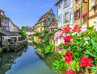
Colmar is a city and commune in the Haut-Rhin department and Alsace region of north-eastern France. The third-largest commune in Alsace, it is the seat of the prefecture of the Haut-Rhin department and of the subprefecture of the Colmar-Ribeauvillé arrondissement.

<span class="mw-page-title-main">Rimbach-près-Masevaux</span> Commune in Grand Est, France

Rimbach-près-Masevaux is a commune in the Haut-Rhin department in Grand Est in north-eastern France.

<span class="mw-page-title-main">Sélestat</span> Subprefecture and commune in Grand Est, France

Sélestat is a commune in the Grand Est region of France. An administrative division (sous-préfecture) of the Bas-Rhin department, the town lies on the Ill river, 17 kilometres (11 mi) from the Rhine and the German border. Sélestat is located between the largest communes of Alsace, Strasbourg and Mulhouse.

<span class="mw-page-title-main">Hombourg-Haut</span> Commune in Grand Est, France

Hombourg-Haut is a commune located in the department of Moselle, region of Grand Est, in the cultural and historical region Lorraine, north-eastern France.

<span class="mw-page-title-main">Munster, Haut-Rhin</span> Commune in Grand Est, France

Munster is a commune in the Haut-Rhin department in Grand Est in north-eastern France. It is located in the valley of the river Fecht, in the Vosges mountains about 15 kilometres west of Colmar on the D417 road to the Col de la Schlucht and Épinal.

<span class="mw-page-title-main">Kaysersberg</span> Part of Kaysersberg Vignoble in Grand Est, France

Kaysersberg is a historical town and former commune in Alsace in northeastern France. The name is German for Emperor's Mountain. The high fortress that dominates the town serves as a reminder of both its strategic importance and its warlike past.

<span class="mw-page-title-main">Unterlinden Museum</span> Art museum, History museum, Design museum in Colmar, France

The Unterlinden Museum is located in Colmar, in the Alsace region of France. The museum, housed in a 13th-century Dominican religious sisters' convent and a 1906 former public baths building, is home to the Isenheim Altarpiece by the German Renaissance painter Matthias Grünewald and features a large collection of local and international artworks and manufactured artifacts from prehistorical to contemporary times. It is a Musée de France. With roughly 200,000 visitors per year, the museum is the most visited in Alsace.

<span class="mw-page-title-main">Lièpvre</span> Commune in Grand Est, France

Lièpvre is a commune in the Haut-Rhin department in Grand Est in north-eastern France. A monastery was built here in the eighth century by Saint Fulrad, who filled it with relics of Saint Cucuphas and Saint Alexander.

<span class="mw-page-title-main">Soultz-Haut-Rhin</span> Commune in Grand Est, France

Soultz-Haut-Rhin is a commune in the Haut-Rhin département in Grand Est in north-eastern France.

<span class="mw-page-title-main">Rouffach</span> Commune in Grand Est, France

Rouffach is a commune in the Haut-Rhin department in Grand Est in north-eastern France.

<span class="mw-page-title-main">Wintzenheim</span> Commune in Grand Est, France

Wintzenheim is a commune in the Haut-Rhin département in Grand Est in north-eastern France.

<span class="mw-page-title-main">Ottrott</span> Commune in Grand Est, France

Ottrott is a commune in the Bas-Rhin department in Grand Est in north-eastern France. It lies southwest of Strasbourg. The vineyards in and around Ottrott produce the red Rouge d'Ottrott, a geographical denomination within the registered designation of origin Alsace AOC.

<span class="mw-page-title-main">Thannenkirch</span> Commune in Grand Est, France

Thannenkirch is a commune and tourist destination in the northeastern French department of Haut-Rhin.

<span class="mw-page-title-main">Wasserbourg</span> Commune in Grand Est, France

Wasserbourg is a commune in the Haut-Rhin department in Grand Est in north-eastern France.

<span class="mw-page-title-main">Château du Hugstein</span> French castle

The Château du Hugstein is a ruined castle on the borders of the communes of Buhl and Guebwiller in the Haut-Rhin département of France.

<span class="mw-page-title-main">Arrondissement of Thann-Guebwiller</span> Arrondissement in Grand Est, France

The arrondissement of Thann-Guebwiller is an arrondissement of France in the Haut-Rhin department in the Grand Est region. It has 81 communes. Its population is 130,270 (2016), and its area is 907.1 km2 (350.2 sq mi).

<span class="mw-page-title-main">Longny les Villages</span> Commune in Normandy, France

Longny les Villages is a commune in the department of Orne, northwestern France. The municipality was established on 1 January 2016 by merger of the former communes of La Lande-sur-Eure, Longny-au-Perche, Malétable, Marchainville, Monceaux-au-Perche, Moulicent, Neuilly-sur-Eure and Saint-Victor-de-Réno. Its seat, Longny-au-Perche, is classed as a Petites Cités de Caractère.

<i>Buhl Altarpiece</i> Church artwork in Buhl, France

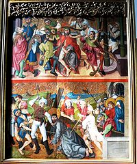
The Buhl Altarpiece is a late 15th-century, Gothic altarpiece of colossal dimensions now kept in the parish church Église Saint-Jean-Baptiste of Buhl in the Haut-Rhin département of France. It was painted by followers of Martin Schongauer, most probably for the convent of the Dominican sisters of Saint Catherine of Colmar, and moved to its present location in the early 19th century. It is classified as a Monument historique by the French Ministry of Culture.

References

  1. "Répertoire national des élus: les maires". data.gouv.fr, Plateforme ouverte des données publiques françaises (in French). 2 December 2020.
  2. "Populations légales 2021" (in French). The National Institute of Statistics and Economic Studies. 28 December 2023.
  3. Population en historique depuis 1968, INSEE
  4. Base Mérimée : Eglise Paroissiale Saint-Jean-Baptiste , Ministère français de la Culture. (in French)