Fellering

Last updated
Fellering
Fellering 044.JPG
The church in Fellering
Blason de la ville de Fellering (68).svg
Location of Fellering
Fellering
France location map-Regions and departements-2016.svg
Red pog.svg
Fellering
Grand Est region location map.svg
Red pog.svg
Fellering
Coordinates: 47°53′49″N6°59′14″E / 47.8969°N 6.9872°E / 47.8969; 6.9872
Country France
Region Grand Est
Department Haut-Rhin
Arrondissement Thann-Guebwiller
Canton Cernay
Intercommunality Vallée de Saint-Amarin
Government
  Mayor (20202026) Nadine Spetz [1]
Area
1
21.29 km2 (8.22 sq mi)
Population
 (Jan. 2021) [2]
1,589
  Density75/km2 (190/sq mi)
Time zone UTC+01:00 (CET)
  Summer (DST) UTC+02:00 (CEST)
INSEE/Postal code
68089 /68470
Elevation426–1,265 m (1,398–4,150 ft)
(avg. 440 m or 1,440 ft)
1 French Land Register data, which excludes lakes, ponds, glaciers > 1 km2 (0.386 sq mi or 247 acres) and river estuaries.

Fellering is a commune in the Haut-Rhin department in Grand Est in north-eastern France.

Contents

Geography

Climate

Fellering has a humid continental climate (Köppen climate classification Dfb) closely bordering on a subarctic climate (Dfc). The average annual temperature in Fellering is 6.0 °C (42.8 °F). The average annual rainfall is 1,523.3 mm (59.97 in) with December as the wettest month. The temperatures are highest on average in August, at around 14.2 °C (57.6 °F), and lowest in January, at around −1.5 °C (29.3 °F). The highest temperature ever recorded in Fellering was 30.3 °C (86.5 °F) on 7 August 2015; the coldest temperature ever recorded was −20.4 °C (−4.7 °F) on 20 December 2009.

Climate data for Le Markstein, Fellering (1981–2010 averages, extremes 1994−present)
MonthJanFebMarAprMayJunJulAugSepOctNovDecYear
Record high °C (°F)13.7
(56.7)
17.1
(62.8)
18.7
(65.7)
21.8
(71.2)
25.4
(77.7)
30.2
(86.4)
30.2
(86.4)
30.3
(86.5)
25.2
(77.4)
22.6
(72.7)
17.7
(63.9)
14.0
(57.2)
30.3
(86.5)
Mean daily maximum °C (°F)0.9
(33.6)
1.2
(34.2)
3.5
(38.3)
7.9
(46.2)
12.5
(54.5)
16.0
(60.8)
17.4
(63.3)
17.4
(63.3)
13.1
(55.6)
9.8
(49.6)
4.2
(39.6)
1.3
(34.3)
8.8
(47.8)
Daily mean °C (°F)−1.5
(29.3)
−1.3
(29.7)
0.9
(33.6)
4.8
(40.6)
9.2
(48.6)
12.5
(54.5)
14.0
(57.2)
14.2
(57.6)
10.2
(50.4)
7.1
(44.8)
2.0
(35.6)
−0.9
(30.4)
6.0
(42.8)
Mean daily minimum °C (°F)−3.8
(25.2)
−3.7
(25.3)
−1.8
(28.8)
1.7
(35.1)
6.0
(42.8)
9.1
(48.4)
10.7
(51.3)
11.0
(51.8)
7.3
(45.1)
4.5
(40.1)
−0.3
(31.5)
−3.2
(26.2)
3.2
(37.8)
Record low °C (°F)−14.9
(5.2)
−18.9
(−2.0)
−16.5
(2.3)
−9.5
(14.9)
−3.5
(25.7)
−0.5
(31.1)
3.4
(38.1)
1.8
(35.2)
−1.1
(30.0)
−8.3
(17.1)
−14.0
(6.8)
−20.4
(−4.7)
−20.4
(−4.7)
Average precipitation mm (inches)139.5
(5.49)
131.5
(5.18)
128.8
(5.07)
86.2
(3.39)
121.7
(4.79)
105.3
(4.15)
128.8
(5.07)
123.0
(4.84)
119.3
(4.70)
140.1
(5.52)
133.9
(5.27)
165.2
(6.50)
1,523.3
(59.97)
Average precipitation days (≥ 1.0 mm)12.212.613.012.113.612.113.112.111.412.613.714.1152.5
Source: Meteociel [3]

Population

Historical population
YearPop.±% p.a.
19681,401    
19751,343−0.60%
19821,454+1.14%
19901,501+0.40%
19991,548+0.34%
20061,674+1.12%
20091,714+0.79%
20141,659−0.65%
20201,599−0.61%
Source: INSEE [4]

See also

Related Research Articles

<span class="mw-page-title-main">Ribeauvillé</span> Subprefecture and commune in Grand Est, France

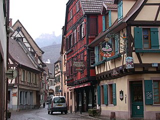
Ribeauvillé (French pronunciation:[ʁibovile] is the French name of Ràppschwihr, a commune in the Haut-Rhin department in Grand Est in north-eastern France. It was a sub-prefecture of the department until 2015.

<span class="mw-page-title-main">Turckheim</span> Commune in Grand Est, France

Turckheim is a commune in the Haut-Rhin department in Grand Est in north-eastern France. It lies west of Colmar, on the eastern slopes of the Vosges mountains.

<span class="mw-page-title-main">Loyettes</span> Commune in Auvergne-Rhône-Alpes, France

Loyette is a commune in the Ain department in eastern France.

<span class="mw-page-title-main">Saint-Rambert-en-Bugey</span> Commune in Auvergne-Rhône-Alpes, France

Saint-Rambert-en-Bugey is a commune in the Ain department in eastern France.

<span class="mw-page-title-main">Bergheim, Haut-Rhin</span> Commune in Grand Est, France

Bergheim is a commune in the Haut-Rhin department in Grand Est in north-eastern France.

<span class="mw-page-title-main">Bitschwiller-lès-Thann</span> Commune in Grand Est, France

Bitschwiller-lès-Thann is a commune in the Haut-Rhin department in Grand Est in north-eastern France.

<span class="mw-page-title-main">Guebwiller</span> Subprefecture and commune in Grand Est, France

Guebwiller is a commune in the Haut-Rhin département in Grand Est currently in north-eastern France. It was a sub-prefecture of the department until 2015.

<span class="mw-page-title-main">Saint-Philippe</span> Commune in Réunion, France

Saint-Philippe is a commune in the French overseas department of Réunion. It is located in southeastern Reunion.

<span class="mw-page-title-main">Ugine</span> Commune in Auvergne-Rhône-Alpes, France

Ugine is a commune in the Savoie department in the Auvergne-Rhône-Alpes region in south-eastern France.

<span class="mw-page-title-main">Courtes</span> Commune in Auvergne-Rhône-Alpes, France

Courtes is a commune in the Ain department in eastern France.

<span class="mw-page-title-main">Ammerschwihr</span> Commune in Grand Est, France

Ammerschwihr is a commune in the Haut-Rhin department in Grand Est in north-eastern France.

<span class="mw-page-title-main">Sainte-Croix-aux-Mines</span> Commune in Grand Est, France

Sainte-Croix-aux-Mines is a commune in the Haut-Rhin department in Grand Est in north-eastern France. It is part of the arrondissement of Colmar-Ribeauvillé.

<span class="mw-page-title-main">Rouffach</span> Commune in Grand Est, France

Rouffach is a commune in the Haut-Rhin department in Grand Est in north-eastern France.

<span class="mw-page-title-main">Courniou</span> Commune in Occitania, France

Courniou is a commune in the Hérault department in southern France.

<span class="mw-page-title-main">Oderen</span> Commune in Grand Est, France

Oderen is a commune in the Haut-Rhin department in Grand Est in north-eastern France.

<span class="mw-page-title-main">Geishouse</span> Commune in Grand Est, France

Geishouse is a commune in the Haut-Rhin department in Grand Est in north-eastern France.

<span class="mw-page-title-main">Kruth</span> Commune in Grand Est, France

Kruth is a commune in the Haut-Rhin department in Grand Est in north-eastern France. Its railway station is the terminus of a TER service to Mulhouse.

<span class="mw-page-title-main">Vic-en-Bigorre</span> Commune in Occitania, France

Vic-en-Bigorre is a commune in the Hautes-Pyrénées department in south-western France.

<span class="mw-page-title-main">Lucelle, Haut-Rhin</span> Commune in Grand Est, France

Lucelle is a commune in the Haut-Rhin department in Alsace in north-eastern France.

<span class="mw-page-title-main">Valserhône</span> Commune in Auvergne-Rhône-Alpes, France

Valserhône is a commune in the Ain department in the Auvergne-Rhône-Alpes region in Eastern France. It is the result of the merger, on 1 January 2019, of the communes of Bellegarde-sur-Valserine, Châtillon-en-Michaille and Lancrans. In 2018, the three communes had a combined population of 16,431, with Bellegarde-sur-Valserine as the major population centre. This makes Valserhône the third-most populated commune of Ain, after Bourg-en-Bresse and Oyonnax.

References

  1. "Répertoire national des élus: les maires". data.gouv.fr, Plateforme ouverte des données publiques françaises (in French). 2 December 2020.
  2. "Populations légales 2021". The National Institute of Statistics and Economic Studies. 28 December 2023.
  3. "Normales et records pour Markstein Crete (68)". Meteociel. Retrieved 15 June 2022.
  4. Population en historique depuis 1968, INSEE