The city and Buka Island are separated from the northern tip of Bougainville Island by the deep, narrow Buka Passage, which varies in width from 980 to 3,000 feet (300 to 1,070 metres). Both islands are in the northern Solomon Islands archipelago and the only major ones not within the nation of Solomon Islands.
Buka Island is volcanic formation measuring 35 miles by 9 miles (56km by 14km), with a total land area of 190 square miles (492km²). The elevation reaches to 1,634 feet (498 metres) in the hills in the southwest, and the interior of the island is densely forested.[1] Rainfall is abundant, with more than 100 inches (2,500mm) annually. Coral reefs fringe the south and west coasts, the latter deeply indented by Queen Carola Harbour.
Buka consists of three major geological units: a plateau of uplifted coral reefs, steep hills and coral formations of post-Pleistocene age.[4]
Discovered by Europeans in 1768,[5] the German Empire laid claim to the island in 1899, annexing it into German New Guinea. Buka became the capital of the Bougainville Province decades later, during the 1990s Bougainville Civil War. The former, or "proper" capital of Bougainville, Arawa, was all but destroyed in 1990 as tensions reached a critical level in a civil uprising, which ended with the Bougainville Peace Agreement in 1998. The Bougainville government intends to return the capital to Arawa in the future.[6]
↑ Specht, Jim (July 1974). "Of Menak and Men: Trade and the Distribution of Resources on Buka Island, Papua New Guinea". Ethnology. 13 (3): 225–237. doi:10.2307/3773164. JSTOR3773164.
Connell, John (2017). "Environmental Refugees? A tale of two resettlement projects in coastal Papua New Guinea". Australian Geographer. 48: 79–95. doi:10.1080/00049182.2016.1267603. S2CID151425246.
Bougainville, officially the Autonomous Region of Bougainville, is an autonomous region in Papua New Guinea. The largest island is Bougainville Island, while the region also includes Buka Island and a number of outlying islands and atolls. The current capital is Buka, situated on Buka Island.
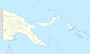
Bougainville Island is the main island of the Autonomous Region of Bougainville, which is part of Papua New Guinea. Its land area is 9,300 km2 (3,600 sq mi). The population of the whole province, including nearby islets such as the Carterets, is approximately 300,000. The highest point is Mount Balbi, on the main island, at 2,715 m (8,907 ft).
Bougainville, an autonomous region of Papua New Guinea (PNG), has been inhabited by humans for at least 29,000 years, according to artefacts found in Kilu Cave on Buka Island. The region is named after Bougainville Island, the largest island of the Solomon Islands archipelago, but also contains a number of smaller islands.
Kieta is a port town located on the eastern coast of the island of Bougainville in Papua New Guinea, near the township of Arawa. After extensive destruction during the 1990 Civil Uprising on Bougainville, Kieta has few inhabitants now, and is known mainly for its transport connections.
Buka Island is the second-largest island in the Autonomous Region of Bougainville, in eastern Papua New Guinea. It is in Buka Rural LLG of North Bougainville District, with the Autonomous Region's and district's capital city of Buka on the island.
The Solomon Sea is a sea located within the Pacific Ocean. It lies between Papua New Guinea and Solomon Islands. Many major battles were fought there during World War II.
UTC+11:00 is an identifier for a time offset from UTC of +11:00. This time is used in:
The Carteret Islands are Papua New Guinea islands located 86 km (53 mi) north-east of Bougainville in the South Pacific. The atoll has a scattering of low-lying islands called Han, Jangain, Yesila, Yolasa and Piul, in a horseshoe shape stretching 30 km (19 mi) in north-south direction, with a total land area of 0.6 square kilometres (0.2 sq mi) and a maximum elevation of 1.5 metres above sea level.
The Flag of Bougainville is a symbol of the Autonomous Region of Bougainville in Papua New Guinea. It was originally adopted in 1975 by the secessionist Republic of the North Solomons.
The Nukumanu Islands, formerly the Tasman Islands, is an atoll of Papua New Guinea, located in the south-western Pacific Ocean, 4 degrees south of the Equator.
Arawa is the largest town and the former capital of the Autonomous Region of Bougainville in Papua New Guinea. It is administered under Arawa Rural LLG.
The Solomon Archipelago is a terrestrial ecoregion and marine ecoregion in the Pacific Ocean. It includes the tropical ocean waters surrounding most of the Solomon Islands archipelago, and includes Bougainville Island and Buka Island of Papua New Guinea and their surrounding waters.
Nuguria or the Nuguria Islands, also known as the Abgarris or Fead Islands, are a Polynesian outlier and islands of Papua New Guinea. They are located nearly 150 km from the northern end of Buka island, in the Autonomous Region of Bougainville and consist of two closely spaced atoll formations.
The Solomon Islands (archipelago) is an island group in the western South Pacific Ocean, north-east of Australia. The archipelago is in the Melanesian subregion and bioregion of Oceania and forms the eastern boundary of the Solomon Sea. The many islands of the archipelago are distributed across the sovereign states of Papua New Guinea and Solomon Islands. The largest island in the archipelago is Bougainville Island, which is a part of the Autonomous Region of Bougainville along with Buka Island, the Nukumanu Islands, and a number of smaller nearby islands. Much of the remainder falls within the territory of Solomon Islands and include the atolls of Ontong Java, Sikaiana, the raised coral atolls of Bellona and Rennell, and the volcanic islands of Choiseul, Guadalcanal, Makira, Malaita, New Georgia, the Nggelas, Santa Isabel, and the Shortlands. The Santa Cruz Islands are not a part of the archipelago.
Buin is a town on Bougainville Island, and the capital of the South Bougainville District, in the Autonomous Region of Bougainville, in eastern Papua New Guinea. The island is in the northern Solomon Islands Archipelago of the Melanesia region, in the South Pacific Ocean.
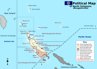
North Bougainville District is a district of the Autonomous Region of Bougainville of Papua New Guinea. Its capital is Buka on Buka Island. North Bougainville languages are spoken in the district.
The Bougainville conflict, also known as the Bougainville Civil War, was a multi-layered armed conflict fought from 1988 to 1998 in the North Solomons Province of Papua New Guinea (PNG) between PNG and the secessionist forces of the Bougainville Revolutionary Army (BRA), and between the BRA and other armed groups on Bougainville. The conflict was described by Bougainvillean President John Momis as the largest conflict in Oceania since the end of World War II in 1945, with an estimated 15,000–20,000 Bougainvilleans dead, although lower estimates place the toll at around 1,000–2,000.
The Our Lady of the Assumption Cathedral is a religious building belonging to the Roman Catholic Church and is located in the town of Buka on the south coast of the island of Buka, in the autonomous region of Bougainville, formerly ″province of Bougainville″ which is part of Papua New Guinea a country in Oceania.
Buka Rural LLG is a local-level government (LLG) of comprising Buka Island in the Autonomous Region of Bougainville, Papua New Guinea. Several Northwest Solomonic languages are spoken in the LLG.
The COVID-19 pandemic in the Autonomous Region of Bougainville is part of the ongoing worldwide pandemic of coronavirus disease 2019 caused by severe acute respiratory syndrome coronavirus 2. The Autonomous Region of Bougainville's confirmed its first case of the COVID-19 pandemic on Friday, August 7, 2020, in Arawa, Bougainville. The first documented arrival of COVID-19 in Bougainville occurred just before the start of the Bougainvillean general and presidential elections, which took place over the course of three weeks beginning on August 12, 2020, and ending on September 1, 2020.
This page is based on this Wikipedia article Text is available under the CC BY-SA 4.0 license; additional terms may apply. Images, videos and audio are available under their respective licenses.