Bulwark, Chepstow

Last updated

Bulwark
One quarter of The Octagon - geograph.org.uk - 1037544.jpg
Housing at The Octagon, Bulwark
Monmouthshire UK location map.svg
Red pog.svg
Bulwark
Location within Monmouthshire
OS grid reference ST 53448 92564
Principal area
Preserved county
Country Wales
Sovereign state United Kingdom
Post town CHEPSTOW
Postcode district NP16
Dialling code 01291
Police Gwent
Fire South Wales
Ambulance Welsh
UK Parliament
Senedd Cymru – Welsh Parliament
List of places
UK
Wales
Monmouthshire
51°37′49″N2°40′25″W / 51.630244°N 2.673712°W / 51.630244; -2.673712

Bulwark is a predominantly residential area of Chepstow, Monmouthshire, Wales, largely developed during the twentieth century. The area is so named because of its Iron Age fort, which is now maintained as a public open space. Substantial development in the area began during the First World War, with housing being provided for the military and civilian workforce brought to the area for the National Shipyard no.1 at Chepstow.

Contents

History

Bulwarks Camp

Bulwarks Camp Bulwark camp.jpg
Bulwarks Camp

Bulwarks Camp, also known in the past as Hardwick Camp and locally as the Warren, is a small defensive hill fort, on top of cliffs overlooking the River Wye, the Beachley peninsula and the Severn estuary. It was probably built around the first century BC or the first century AD. The Romans called the inhabitants of the area the Silures; they would have spoken the language that became Welsh. The fort had cliffs to the east, a ravine to the south, and earthworks comprising a double rampart and ditch on the other two sides. Excavations in 1968 revealed traces of three buildings inside the ramparts, and indicated that it had remained inhabited after the start of the Roman occupation. [1] The site is now in the care of Cadw and is used as a public open space. [2] [3]

Hardwick House and nineteenth-century development

Until the nineteenth century, the Bulwark area was generally known as Hardwick, a name given to areas of cattle farming in Saxon times. It may be the "hardwick" mentioned in the Domesday Book under the name of Lamecare, though other sites have also been suggested. The area was predominantly in agricultural use until the twentieth century, with farms including Claypits, St Tecla, and Burnt Barn. The manor house, Hardwick House, was in existence in the 14th century and was rebuilt several times; it was later known as Hardwick Court. The house was demolished in the 1960s, and some of its grounds then became a public open space, known locally as "Piggy's Hill". The area south of the A48 Newport Road contains a number of large 19th-century villas which were on the outskirts of Chepstow when built, and commanded extensive views eastwards towards Sedbury. Nearby, on the road towards Mathern, Chepstow Cemetery was established in 1855, after the town's churchyard was deemed to be overcrowded; it received its first burials two years later. [4]

Bulwark Garden Suburb

"Garden Suburb" housing in Bulwark Camp Road, Bulwark Garden City - geograph.org.uk - 1037493.jpg
"Garden Suburb" housing in Bulwark

Bulwark Garden Suburb was developed between 1917 and 1919, as housing for the workers at the National Shipyard which was established during the First World War south-east of the railway line at Chepstow. [4] The housing was centred on The Octagon, at the intersection of Bulwark Avenue and Victoria Road, where it was designed by Henry Farmer of the Admiralty with advice from the architect and writer Henry Avray Tipping of Mounton. [5] Elsewhere, concrete huts were built as temporary housing, some of which were later converted into industrial units. Several of these were used as workshops by the Red & White Bus Company, which established its headquarters on Bulwark Road in 1938. During the Second World War, most of the huts were converted into accommodation for prisoners of war, and the area was later redeveloped as an industrial estate. [4]

Bulwark Road Junction of Mathern Road with Bulwark Road - geograph.org.uk - 1379708.jpg
Bulwark Road

Later development

The first council houses in the area were built by Chepstow Urban District Council in the St Tecla area, near to Hardwick Court, in the 1930s, in part to house residents moved out of the Thomas Street area of the town centre in a slum clearance project. [4] Development continued thereafter, accommodating most of Chepstow's development in the mid-twentieth century. A shopping area developed on Bulwark Road, and the Severn Bridge Social Club (closed in 2019) [6] was opened on the site of the former Claypits Farm in 1965. [7] The entire area between the cliffs and the A466 link road to the motorway was developed for new housing by the 1970s. New development later spread southwards into the Thornwell area, beside the motorway junction. The Bulwark and Thornwell areas together accommodate over half of the resident population of Chepstow.

St Christopher's Church St. Christopher's church and a supermarket car park - geograph.org.uk - 1379680.jpg
St Christopher's Church

Governance

The areas known as Bulwark and Thornwell together comprise the wards of Larkfield, St Christopher's and Thornwell on Monmouthshire County Council. Following the 2012 local elections, current councillors are Phyl Hobson (Liberal Democrat, Larkfield), Armand Watts (Labour, Thornwell), and Dimitri Batrouni (Labour, St Christopher's). [8]

Facilities

Bulwark contains three primary schools (Pembroke Primary School, Thornwell Primary School and St. Mary's R.C. Primary School), the Two Brewers pub, [9] and Bulwark Community Centre. [10] Churches include St Christopher's (Church in Wales) and St Mary's (Catholic). [11] The Bulwark shopping centre includes a Lidl store.

Notable residents

Hardwick House was the home of the Bishop of Llandaff, Edward Copleston (1776-1849), between 1836 and his death. Bulwark was also the childhood home of Richard William Church (1815-1890), Dean of St Paul's Cathedral and writer.

Related Research Articles

<span class="mw-page-title-main">Chepstow</span> Human settlement in Wales

Chepstow is a town and community in Monmouthshire, Wales, adjoining the border with Gloucestershire, England. It is located on the tidal River Wye, about 2 miles (3 km) above its confluence with the River Severn, and adjoining the western end of the Severn Bridge. It is the easternmost settlement in Wales, situated 16 miles (26 km) east of Newport, 28 miles (45 km) east-northeast of Cardiff, 18 miles (29 km) northwest of Bristol and 110 miles (180 km) west of London.

<span class="mw-page-title-main">Caldicot, Monmouthshire</span> Town in Wales

Caldicot is a market town and community in Monmouthshire, Wales. The town is located between Chepstow and the city of Newport. The site adjoins the Caldicot Levels, on the north side of the Severn Estuary. The population of the built-up area was around 11,000. It has a large school, Caldicot School, and is known for its medieval castle. The built-up area includes Portskewett. Caldicot had a population of 9,604 in 2011.

<span class="mw-page-title-main">A48 road</span> Trunk road in Great Britain

The A48 is a trunk road in Great Britain running from the A40 at Highnam, 3 miles (4.8 km) west of Gloucester, England, to the A40 at Carmarthen, Wales. Before the Severn Bridge opened on 8 September 1966, it was a major route between England and South Wales. For most of its route, it runs almost parallel to the M4 motorway. During times of high winds at the Severn Bridge, the A48 is used as part of the diversion route and is still marked as a Holiday Route.

<span class="mw-page-title-main">Chepstow Castle</span> Castle in Chepstow, Monmouthshire, Wales

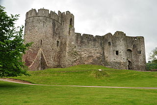
Chepstow Castle at Chepstow, Monmouthshire, Wales is the oldest surviving post-Roman stone fortification in Britain. Located above cliffs on the River Wye, construction began in 1067 under the instruction of the Norman Lord William FitzOsbern. Originally known as Striguil, it was the southernmost of a chain of castles built in the Welsh Marches, and with its attached lordship took the name of the adjoining market town in about the 14th century.

<span class="mw-page-title-main">Piercefield House</span> Neoclassical country house in Wales

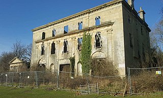
Piercefield House is a largely ruined neo-classical country house near St Arvans, Monmouthshire, Wales, about 1.5 miles (2.4 km) north of the centre of Chepstow. The central block of the house was designed in the very late 18th century, by, or to the designs of, Sir John Soane. It is flanked by two pavilions, of slightly later date, by Joseph Bonomi the Elder. The house sits within Piercefield Park, a Grade I listed historic landscape, that was created in the 18th century as a notable Picturesque estate.

<span class="mw-page-title-main">Magor, Monmouthshire</span> Human settlement in Wales

Magor is a large village in Monmouthshire, south east Wales, about 9 miles (14 km) west of Chepstow and about 9 miles (14 km) east of Newport. It lies on the Caldicot Levels beside the Severn Estuary, and is in the community of Magor with Undy. Magor lies close to the M4 motorway.

<span class="mw-page-title-main">Sedbury</span> Human settlement in England

Sedbury is a village in the Forest of Dean district of west Gloucestershire, England. It is located on the eastern bank of the River Wye, facing the town of Chepstow in Monmouthshire. The village is in the parish of Tidenham. It had a population of 3,535. Nearby are the villages of Tutshill, Woodcroft and Beachley.

<span class="mw-page-title-main">Shirenewton</span> Village and community in Monmouthshire, Wales, UK

Shirenewton is a village and community in Monmouthshire, south east Wales. It is located 3 miles due west of Chepstow, 5 miles (8 km) by road. The village stands around 500 feet above sea level, and has extensive views of the Severn Estuary and Bristol Channel. The population of the village and the conjoined village of Mynydd-bach was 657 in 2011.

<span class="mw-page-title-main">Llanvair Discoed</span> Human settlement in Wales

Llanvair Discoed is a small village in Monmouthshire, south-east Wales, 6 miles west of Chepstow and 10 miles east of Newport.

<span class="mw-page-title-main">Raglan, Monmouthshire</span> Village in Monmouthshire, Wales

Raglan (; is a village and community in Monmouthshire, south east Wales, United Kingdom. It is located some 9 miles south-west of Monmouth, midway between Monmouth and Abergavenny on the A40 road very near to the junction with the A449 road. The fame of the village derives from Raglan Castle, built for William ap Thomas and now maintained by Cadw. The community includes the villages of Llandenny and Pen-y-clawdd. Raglan itself has a population of 1,183.

<span class="mw-page-title-main">Tutshill</span> Human settlement in England

Tutshill is a village within the parish of Tidenham in the Forest of Dean, Gloucestershire, England. It is located on the eastern bank of the River Wye, which forms the boundary with Monmouthshire at this point and which separates the village from the town of Chepstow. The village of Woodcroft adjoins Tutshill to the north, and across the A48 road to the south is the village of Sedbury. A short walk over the river is Chepstow railway station on the Gloucester–Newport line.

<span class="mw-page-title-main">Portskewett</span> Village and community in Monmouthshire, Wales

Portskewett is a village and community (parish) in Monmouthshire, south east Wales. It is located four miles south west of Chepstow and one mile east of Caldicot, in an archaeologically sensitive part of the Caldicot Levels on the Welsh shore of the Severn Estuary. The Second Severn Crossing passes overhead carrying the M4 motorway. The community includes Sudbrook, Crick and Leechpool.

<span class="mw-page-title-main">Sudbrook, Monmouthshire</span> Human settlement in Wales

Sudbrook is a village in Monmouthshire, south east Wales. It is located 4 miles south west of Chepstow and 1 mile east of Caldicot. It lies close to the Second Severn Crossing on the Severn Estuary, and adjoins the village of Portskewett. It was largely built in the late 19th century for workers on the Severn railway tunnel. At that time it was also known as Southbrook.

<span class="mw-page-title-main">St Pierre, Monmouthshire</span> Human settlement in Wales

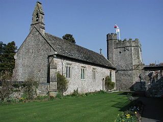
St Pierre is a former parish and hamlet in Monmouthshire, south east Wales, 3 miles (4.8 km) south west of Chepstow and adjacent to the Severn Estuary. It is now the site of a large golf and country club, the Marriott St Pierre Hotel & Country Club, which was previously a large manor house and deer park belonging to the Lewis family.

Eric Carwardine Francis was a British architect and painter who designed a number of notable buildings, particularly in Monmouthshire, Gloucestershire and Somerset, in the early and mid-twentieth century, many in the Arts and Crafts style.

<span class="mw-page-title-main">Grade I listed buildings in Monmouthshire</span>

Monmouthshire is a county and principal area of Wales. It borders Torfaen and Newport to the west; Herefordshire and Gloucestershire to the east; and Powys to the north. The largest town is Abergavenny, with the other major towns being Chepstow, Monmouth, and Usk. The county is 850 km2 in extent, with a population of 95,200 as of 2020. The present county was formed under the Local Government (Wales) Act 1994, which came into effect in 1996, and comprises some sixty percent of the historic county. Between 1974 and 1996, the county was known by the ancient title of Gwent, recalling the medieval Welsh kingdom. In his essay on local government in the fifth and final volume of the Gwent County History, Robert McCloy suggests that the governance of "no county in the United Kingdom in the twentieth century was so transformed as that of Monmouthshire".

<span class="mw-page-title-main">Grade II* listed buildings in Monmouthshire</span> List of buildings in principal area of Wales

Monmouthshire is a county and principal area of Wales. It borders Torfaen and Newport to the west; Herefordshire and Gloucestershire to the east; and Powys to the north. The largest town is Abergavenny, with the other major towns being Chepstow, Monmouth, and Usk. The county is 850 km2 in extent, with a population of 95,200 as of 2020. The present county was formed under the Local Government (Wales) Act 1994, which came into effect in 1996, and comprises some sixty percent of the historic county. Between 1974 and 1996, the county was known by the ancient title of Gwent, recalling the medieval Welsh kingdom. In his essay on local government in the fifth and final volume of the Gwent County History, Robert McCloy suggests that the governance of "no county in the United Kingdom in the twentieth century was so transformed as that of Monmouthshire".

<span class="mw-page-title-main">Wyndcliff</span>

The Wyndcliff or Wynd Cliff is a steep limestone cliff rising above the western bank of the River Wye in Monmouthshire, Wales, some 1 mile (1.6 km) north-east of the village of St Arvans, 2.5 miles (4.0 km) south of Tintern, and 3.5 miles (5.6 km) north of the town of Chepstow, within the Wye Valley Area of Outstanding Natural Beauty. The cliff rises to 771 feet (235 m) at its summit, the highest point on the Monmouthshire bank of the Wye. The area is traversed by the Wye Valley Walk, and is also a popular venue for rock climbing. Access is provided by the A466 road which passes along the valley immediately below the cliff face.

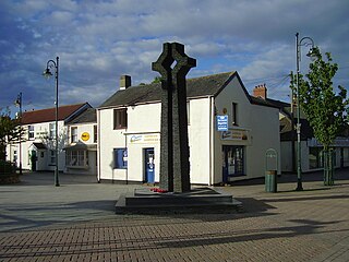
Larkfield is an electoral ward in Chepstow, Monmouthshire. The ward elects councillors to Chepstow Town Council and Monmouthshire County Council.

References

  1. BBC: Bulwarks Camp Archived 21 July 2012 at archive.today . Accessed 16 February 2012
  2. Cadw: Bulwarks Camp. Accessed 16 February 2012
  3. Gathering the Jewels: Aerial photograph of Bulwarks camp [ permanent dead link ]. Accessed 21 March 2012
  4. 1 2 3 4 Ivor Waters (1972). The Town of Chepstow. ISBN   0-900278-12-9.
  5. John Newman, The Buildings of Wales: Gwent/Monmouthshire, Penguin Books, 2000, ISBN   0-14-071053-1, p.188
  6. Saul Cooke-Black, "New Lidl on site of Severn Bridge Social Club in Chepstow", South Wales Argus, 30 September 2021. Retrieved 30 September 2021
  7. Severn Bridge Social Club. Accessed 16 February 2012
  8. South Wales Argus, Local Elections 2012, Monmouthshire County Council Archived 9 May 2012 at the Wayback Machine . Accessed 8 May 2012
  9. Two Brewers at gkpubs.co.uk. Accessed 17 February 2012
  10. Bulwark Community Centre Archived 19 March 2012 at the Wayback Machine . Accessed 16 February 2012
  11. St Mary's Church website Archived 8 November 2010 at the Wayback Machine . Accessed 16 February 2012