Bundala National Park

Last updated

Bundala National Park
Wildlife Preserve Near Kirinda, Sri Lanka.jpg
Sunset near Kirinda
Sri Lanka rel-2 location map.svg
Red pog.svg
Location of Bundala National Park
Location Southern Province, Sri Lanka
Nearest city Hambantota
Coordinates 6°12′50″N81°13′30″E / 6.21389°N 81.22500°E / 6.21389; 81.22500
Area3,339.38 hectares (12.8934 sq mi) after regazzetting in 2004, originally of 6,216 hectares (24.00 sq mi) [1]
Established1969 (sanctuary)
1993 (national park)
Governing body Department of Wildlife Conservation
Official nameBundala
Designated15 June 1990
Reference no.487 [2]

Bundala National Park is an internationally important wintering ground for migratory water birds in Sri Lanka. Bundala harbors 197 species of birds, the highlight being the greater flamingo, which migrate in large flocks. [1] Bundala was designated a wildlife sanctuary in 1969 and redesignated to a national park on 4 January 1993. [3] In 1991 Bundala became the first wetland to be declared as a Ramsar site in Sri Lanka. In 2005 the national park was designated as a biosphere reserve by UNESCO, the fourth biosphere reserve in Sri Lanka. [4] The national park is situated 245 kilometres (152 mi) southeast of Colombo. [5]

Contents

History

The area was declared a wildlife sanctuary on 5 December 1969, [6] and was upgraded to a national park on 4 January 1993 with land area of 6,216 hectares (24.00 sq mi). [7] However the park was regazetted in 2004 and the original park was reduced to 3,698 hectares (14.28 sq mi). [1] In 1991, Bundala became the first site in Sri Lanka to be designated a Ramsar wetland. In 2005, Bundala was declared a Man and Biosphere Reserve by UNESCO. In January 2006, an area adjacent to Bundala covering an area of 3,339.38 hectares (12.8934 sq mi) was declared as the Wilmanna Sanctuary. [1]

Physical features

The area mainly underlain with hornblende-biotite gneiss of the eastern Vijayan series. [1] The low country dry zone climate prevails in the area. The area has an average relative humidity of 80%. The national park contains five shallow, brackish lagoons with salt pans in three. They are Bundala lagoon of 520 hectares (2.0 sq mi), Embilikala Lagoon of 430 hectares (1.7 sq mi), Malala Lagoon of 650 hectares (2.5 sq mi), Koholankala lagoon of 390 hectares (1.5 sq mi), and Mahalewaya of 260 hectares (1.0 sq mi). The Koholankala and Mahalewaya are almost totally developed for salt production. The climatic conditions are tropical monsoonal, with a mean annual temperature of 27 °C (81 °F). Annual rainfall ranges from 900–1,300 millimetres (35–51 in), with dry period persists from May to September. The elevation of the park ranges from sea level to 10 metres (33 ft). [6] The park was affected by 2004 Indian Ocean tsunami. [8] Due to protection from sand dunes the park received very little damage. [9]

Flora

The ecological areas of the national park contain seven terrestrial habitat types and six wetland types. [1] The dry thorny shrubs and herbs being the most abundant plant life. A total of 383 plant species belonging to 90 families have been recorded from the park. [8] "The Phytoplankton in all the lagoons is dominated by blue-green algae" including species such as Macrocystis , Nostoc , Oscillatoria . [6] Hydrilla is in abundance in Malala-Ambilikala Lagoons. Water hyacinth, water lilies, and Typha angustifolia reed beds are found in the marshes and streams. The vegetation mainly consists of Acacia scrubs including Dichrostachys cinerea , Randia dumetorum, Ziziphus sp., Gymnosporia emarginata, Carissa spinarum, Capparis zeylanica and Cassia spp. The trees of the forest are Bauhinia racemosa, Salvadora persica , Drypetes sepiaria, Manilkara hexandra (Palu in Sinhalese), and less common Chloroxylon swietenia , Azadirachta indica , and Feronia limonia . Halophyte plants thrive in the national park's environmental conditions. Salicornia brachiata and Halosarcia indica are examples of salt-tolerant plants. In the small degraded patch of mangrove found at the Bundala lagoon area, Lumnitzera racemosa trees are widespread. [1] The strip of Palu tree Manilkara hexandra forest on the sand-dunes east of Bundala village is a unique type of forest in Sri Lanka.

Fauna

Blue-tailed bee-eater SL Bundala NP asv2020-01 img08.jpg
Blue-tailed bee-eater
Toque macaque SL Bundala NP asv2020-01 img30.jpg
Toque macaque

The Bundala National Park has been identified as an outstanding Important Bird Area in the South Indian and Sri Lankan wetlands. [10] 324 species of vertebrates have been recorded in the national park, [1] which include 32 species of fish, 15 species of amphibians, 48 species of reptiles, 197 species of birds and 32 species of mammals. 52 species of butterflies are among the invertebrates. [8] The wetland habitats in Bundala harbours about 100 species of water birds, half of them being migrant birds. [1] Of 197 avifaunal species 58 are migratory species. National Bird Ringing Programme (NBRP) was launched in Bundala by in collaboration of Department of Wildlife Conservation and Field Ornithology Group of Sri Lanka in 2005. [11]

The greater flamingo Phoenicopterus roseus which visits in large flocks of over 1,000 individuals, from Rann of Kutch of India is being the highlight. Waterfowl (lesser whistling duck Dendrocygna javanica, garganey Anas querquedula), cormorants (little cormorant Phalacrocorax niger, Indian cormorant P. fuscicollis), large water birds (grey heron Ardea cinerea, black-headed ibis Threskiornis melanocephalus, Eurasian spoonbill Platalea leucorodia, Asian openbill Anastomus oscitans, painted stork Mycteria leucocephala), medium-sized waders ( Tringa spp.), and small waders ( Charadrius spp.) are the other avifaunal species which are present in large flocks. Black-necked stork Ephippiorhynchus asiaticus, lesser adjutant Leptoptilos javanicus and Eurasian coot Fulica atra are rare birds inhabit in the national park. [1]

A few Asian elephants (Elephas maximus) still inhabit the forests of Bundala. [6] Other mammals seen in the park are toque macaque Macaca sinica, common langur Presbytis entellus, jackal Canis aureus, leopard Panthera pardus, fishing cat Felis viverrinus, rusty-spotted cat Felis rubiginosa, mongoose Herpestes spp., wild boar Sus scrofa, mouse deer Tragulus meminna, Indian muntjac Muntiacus muntjak, spotted deer Cervus axis, sambar C. Unicolor, black-naped hare Lepus nigricollis, Indian pangolin Manis crassicaudata, and porcupine Hystrix indica. [6]

Bundala harbors various forms of fishes including salt water dispersants Anguilla bicolor , marine forms Ambassis gymnocephalus, brackish water forms Chanos chanos and freshwater forms Channa striata . [1] Bundala's herpetofauna includes two endemic species, a toad and a snake, Bufo atukoralei and Xenochrophis asperrimus. Among reptiles are mugger crocodile Crocodylus palustris, estuarine crocodile Crocodylus porosus, common monitor Varanus bengalensis, star tortoise Geochelone elegans, python Python molurus, rat snake Pytas mucosus, endemic flying snake Chrysopelea taprobana, cat snakes Boiga spp. and whip snakes Dryophis spp. [6] The adjacent seashore of Bundala is a breeding ground for all five species of globally endangered sea turtles that migrate to Sri Lanka. [1]

Threats and conservation

The water quality in the lagoons has changed by the drainage of excess water from irrigation systems, [12] and release of sludge from the saltern into Bundala lagoon. [1] The habitats of the wading birds and wildlife in the shrub forest and dunes is threatened as a result of the spread of two invasive alien plants, Prosopis juliflora and Opuntia dillenii , around the tidal plains in Malala-Ambilikala Lagoons and the sand dunes and nearby scrub forests. The spread of Prosopis juliflora is made easy by uncontrolled livestock herds.

The seeds of the Opuntia cactuses (called kathu potak in Sinhala) are spread by macaque monkeys, and perhaps other animals and birds, that eat the fruits. It is also spread by people cutting down the cactus but leaving the cuttings, which then re-sprout. No biological control measures have been carried out with the moth Cactoblastis cactorum so far. Manual removal of the cactuses will be impossible as the area where they have spread over is vast. [13]

Conservation projects launched include a turtle conservation project, and an invasive alien plants eradication program aimed at the removal of Prosopis juliflora and Opuntia dillenii. The proposed conservation measures are re-demarcation of the park's boundary and widen the boundary to include the northern scrubland, resettle families inhabiting within the park, a programme to control spread of invasive alien plants, create irrigation structures to stop the flow of irrigation water and management of livestock grazing. [1]

See also

Related Research Articles

<span class="mw-page-title-main">Horton Plains National Park</span> National park in Sri Lanka

Horton Plains National Park is a national park in the central highlands of Sri Lanka that was designated in 1988. It is located at an elevation of 2,100–2,300 m (6,900–7,500 ft) and encompasses montane grassland and cloud forest. It is rich in biodiversity and many species found here are endemic to the region. It is also a popular tourist destination and is situated 8 kilometres (5.0 mi) from Ohiya, 6 kilometres (3.7 mi) from the world-famous Ohiya Gap/Dondra Watch and 32 kilometres (20 mi) from Nuwara Eliya.

<span class="mw-page-title-main">Yala National Park</span> National park in Sri Lanka

Yala (යාල) National Park is the most visited and second largest national park in Sri Lanka, bordering the Indian Ocean. The park consists of five blocks, with three of which are now open to the public. There are also two adjoining parks, Kumana National Park or 'Yala East' and Lunugamvehera National Park. The blocks have individual names, such as Palatupana. It is situated in the southeastern region of the country, in the Southern Province and Uva Province. The park covers 979 square kilometres (378 sq mi) and is located about 300 kilometres (190 mi) from Colombo. Yala was designated as a wildlife sanctuary in 1900, along with Wilpattu, designated in 1938, as the first two designated national parks in Sri Lanka. The park is best known for its variety of wildlife and is important conservation of Sri Lankan elephants, Sri Lankan leopards and aquatic birds.

<span class="mw-page-title-main">Keoladeo National Park</span> Bird sanctuary in Rajasthan, India

Keoladeo National Park or Keoladeo Ghana National Park is a famous avifauna sanctuary in Bharatpur, Rajasthan, India, that hosts thousands of birds, especially during the winter season. Over 350 species of birds are known to be resident. It is also a major tourist centre with scores of ornithologists arriving here in the hibernal season. It was declared a protected sanctuary in 1971 and established as a national park on 10 March 1982. Because of its exceptional avian biodiversity, in 1985 Keoladeo National Park was also declared a UNESCO World Heritage Site.

<i>Prosopis juliflora</i> Species of legume

Prosopis juliflora is a shrub or small tree in the family Fabaceae, a kind of mesquite. It is native to Mexico, South America and the Caribbean. It has become established as an invasive weed in Africa, Asia, Australia and elsewhere. It is a contributing factor to continuing transmission of malaria, especially during dry periods when sugar sources from native plants are largely unavailable to mosquitoes.

<span class="mw-page-title-main">Khangchendzonga National Park</span> Protected area and UNESCO World Heritage Site in Sikkim, India

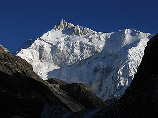
Khangchendzonga National Park, also Kanchenjunga Biosphere Reserve, is a national park and a biosphere reserve located in Sikkim, India. It was inscribed to the UNESCO World Heritage Sites list in July 2016, becoming the first "Mixed Heritage" site of India. It was included in the UNESCO Man and the Biosphere Programme. The park is named after the mountain Kangchenjunga, which is the third-highest peak in the world at 8,586 m (28,169 ft) tall. The total area of the park is 849.5 km2 (328.0 sq mi).

The Rann of Kutch Wildlife Sanctuary is the largest Ramsar site in Sindh, covering 566,375 ha, and is located in the Rann of Kutch in Badin District, Sindh, Pakistan. It was declared a wildlife sanctuary by the government of Sindh in 1980.

<i>Opuntia stricta</i> Species of cactus

Opuntia stricta is a species of large cactus that is endemic to the subtropical and tropical coastal areas of the Americas, especially around the Caribbean. Common names include erect prickly pear and nopal estricto (Spanish). The first description as Cactus strictus was published in 1803 by Adrian Hardy Haworth. In 1812 he moved the species to the genus Opuntia.

<span class="mw-page-title-main">West Coast National Park</span> Nature reserve north of Cape Town in the Western Cape province of South Africa

The West Coast National Park lies 88 km (55 mi) north of Cape Town in the Western Cape province of South Africa. The park is found inside of the Cape West Coast Biosphere Reserve, part of the UNESCO Man and the Biosphere Programme. It is bordered by the Atlantic Ocean on the west and the R27 coastal road, and runs from the town of Yzerfontein in the south, up to the Langebaan Lagoon. The park is particularly well known for its bird life and for the spring flowers which occur in the months from August to September, especially in the Postberg flower reserve section of the park. The park, with the islands in Saldanha Bay, has been identified by BirdLife International as an Important Bird Area. The park was proclaimed in 1985, and is 36,259.8 hectares (140.000 sq mi) in size.

<span class="mw-page-title-main">Central Asian Flyway</span>

The Central Asian Flyway (CAF), Central Asian-Indian Flyway, or Central Asian-South Asian Flyway is a flyway covering a large continental area of Eurasia between the Arctic Ocean and the Indian Ocean and the associated island chains. The CAF comprises several important migration routes of waterbirds, most of which extend from the northernmost breeding grounds in Siberia to the southernmost non-breeding wintering grounds in West Asia, India, the Maldives and the British Indian Ocean Territory.

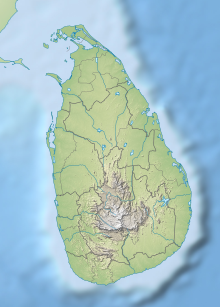
Protected areas of Sri Lanka are administrated by Department of Forest Conservation and Department of Wildlife Conservation of Sri Lanka.There are 501 protected areas in Sri Lanka. The protected areas that fall under supervision of the Department of Forest Conservation include forests defined in National Heritage Wilderness Area Act in 1988, forest reservations, and forests managed for sustainability. Sinharaja Forest Reserve is an example for a National Heritage forest. There are 32 forests categorized as conservation forests including Knuckles Mountain Range. Strict nature reserves, national parks, nature reserves, forest corridors, and sanctuaries recognized under the Flora and Fauna Protection Ordinance are managed by Department of Wildlife Conservation. Total of all protected areas is 1,767,000 ha. Protected areas in Sri Lanka account for 26.5 percent of the total area. This is a higher percentage of protected areas than in all of Asia and much of the World.

<span class="mw-page-title-main">Kumana National Park</span> National park in Sri Lanka

Kumana National Park in Sri Lanka is renowned for its avifauna, particularly its large flocks of migratory waterfowl and wading birds. The park is 391 kilometres (243 mi) southeast of Colombo on Sri Lanka's southeastern coast. Kumana is contiguous with Yala National Park. Kumana was formerly known as Yala East National Park, but changed to its present name on 5 September 2006.

<span class="mw-page-title-main">Alakol Biosphere Reserve</span> Biospehere reserve in the country of Kazakhstan

The Alakol Biosphere Reserve is a UNESCO Biosphere Reserve located in Kazakhstan, within the desert zone of Eurasia in the central part of the Alakol inter-mountain depression. The 193,089 hectares (745.52 sq mi) reserve lies on the Central Asian–Indian bird migration route. The wetlands of the reserve are of global significance as a habitat and as a nesting site for water birds.

<span class="mw-page-title-main">Ciénaga de Zapata Biosphere Reserve</span>

The Ciénaga de Zapata Biosphere Reserve is a UNESCO Biosphere Reserve situated on the southern coast of Cuba at Matanzas province. The 628,171 hectares (2,425.38 sq mi) reserve encompasses the Zapata Swamp and is one of the largest and most important wetlands in the Caribbean region with a marine southern borderline. Ciénaga de Zapata was designated a Ramsar site in 2001. This area is a cluster biosphere reserve with several core areas, highly valuable for conservation located in the Ciénaga de Zapata National Park.

<span class="mw-page-title-main">Ría Lagartos Biosphere Reserve</span> UNESCO Biosphere Reserve in Yucatán, Mexico

Ría Lagartos Biosphere Reserve is a UNESCO Biosphere Reserve in the state of Yucatán, Mexico. The reserve is located at the eastern end of the coastal strip of the Yucatán Peninsula, with the Gulf of Mexico at its northern limit. The area encompasses coastal areas of the Gulf of Mexico and includes important wetlands designated under the Ramsar Wetlands Convention. The site presents a rich diversity of landscapes and ecosystems, such as mangroves, small estuaries, medium semi-evergreen forest, low deciduous forest, coastal dune vegetation, coastal lagoons, marshes (petenes) and savanna represented by tular vegetation, grasslands and reed beds that are the main nesting sites for marshland and sea birds.

La Encrucijada Biosphere Reserve is a UNESCO Biosphere Reserve situated in the Pacific Coastal Lowlands physiographic region of Mexico. It covers 144,848 hectares (559.26 sq mi) stretching over six municipalities in the Costa de Chiapas. It is composed of two large coastal lagoon systems that correspond to two core areas, and a wide variety of natural ecosystems including mangroves, zapotonales, tule swamps and marshes, as well as patches of tropical seasonal forest, coastal dunes and palm trees.

<span class="mw-page-title-main">Prespa National Park (Albania)</span> National park and tourist attraction in southeastern Albania

Prespa National Park is a national park situated in southeastern Albania on the border triangle shared with Greece and North Macedonia. At approximately 277.5 km2 (107.1 sq mi), the park encompasses the country's sections of the Great and Small Prespa Lake. It is considerably characterised by high mountains, narrow islands, vast freshwater wetlands, salt marshes, meadows, reed beds and dense forests.

Malala-Ambilikala Lagoons are two interconnected coastal water-bodies located inside the Bundala National Park, Hambantota District in the Southern Province, Sri Lanka. It is 260 km (160 mi) from Colombo to the arid south. The Malala-Ambilikala Lagoons are two of the three key lagoons located within the Bundala Ramsar wetlands.

Sri Lanka exhibits a remarkable biological diversity and is considered to be the richest country in Asia in terms of species concentration.

References

  1. 1 2 3 4 5 6 7 8 9 10 11 12 13 14 "Wetland Cluster within Bundala National Park". Sri Lanka Wetlands Information and Database. IWMI. Archived from the original on 15 August 2011. Retrieved 10 September 2010.
  2. "Bundala". Ramsar Sites Information Service. Retrieved 25 April 2018.
  3. Senarathna, P.M. (2005). Sri Lankawe wananthara (in Sinhala) (1st ed.). Sarasavi publishers. pp. 197–198. ISBN   978-955-573-401-1.
  4. "Twenty-three New Biosphere Reserves Added to UNESCO's Man and the Biosphere (MAB) Network". unesco.org. UNESCO. 29 June 2005. Archived from the original on 3 February 2009. Retrieved 20 May 2009.
  5. Senarathna, P. M. (2004). Sri Lankawe Jathika Vanodhyana[National Parks of Sri Lanka] (in Sinhala). Sarasavi Publishers. p. 195. ISBN   978-955-573-346-5.
  6. 1 2 3 4 5 6 Green, Michael J. B. (1990). IUCN directory of South Asian protected areas. IUCN. pp.  198–201. ISBN   978-2-8317-0030-4.
  7. The National Atlas of Sri Lanka. Department of Survey. 2007. p. 88. ISBN   978-955-9059-04-2.
  8. 1 2 3 Bambaradeniya, C. N. B. Impacts of the recent tsunami on the Bundala National Park – The first Ramsar wetland in Sri Lanka (PDF). The World Conservation Union. Archived from the original (PDF) on 24 July 2011. Retrieved 11 September 2010.
  9. Conservation of Migratory species of Sri Lanka (PDF). Bonn Convention. p. 6.
  10. "South Indian and Sri Lankan wetlands" (PDF). BirdLife International. Archived from the original (PDF) on 30 November 2010. Retrieved 11 September 2010.
  11. Kotagama, Sarath W.; Bellio, Maria Grazia; Dayananda, Kariyawasam (2006). "Pioneering shorebird research in Sri Lanka: launch of the National Bird Ringing Programme" (PDF). Wader Study Group Bulletin. 109. Archived from the original (PDF) on 23 July 2011. Retrieved 11 September 2010.
  12. Piyankarage S. C., A. P. Mallawatantri, Y. Matsuno, and K. A. S. Pathiratne. 2004. Human impacts and the status of water quality in the Bundala Ramsar wetland lagoon system in southern Sri Lanka. Wetlands Ecology and Management 12(5): 473–482.
  13. Lalith Gunasekera, Invasive Plants: A guide to the identification of the most invasive plants of Sri Lanka, Colombo 2009, pp. 114–115. A biodiversity status profile of Bundala National Park: a Ramsar national wetland of Sri Lanka Bambaradeniya, Channa N.B.; Ekanayake, S.P.; Fernando, R.H.S.S.; Perera, W.P.N.; Somaweera, R. Colombo: IUCN Sri Lanka, 2002. ISBN   955-8177-16-4