This is a list of the National Register of Historic Places listings in Washington County, Pennsylvania.

This is a list of the National Register of Historic Places listings in York County, Pennsylvania.
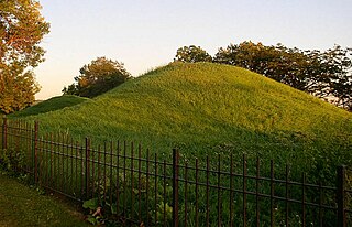
Indian Mounds Regional Park is a public park in Saint Paul, Minnesota, United States, featuring six burial mounds overlooking the Mississippi River. The oldest mounds were constructed beginning about 2,500 years ago by local Indigenous people linked to the Archaic period, who may have been inspired by of the burial style known as the Hopewell Tradition. Mdewakanton Dakota people are also known from historic documents to have interred their dead here well into the historic period. At least 31 mounds were destroyed by development in the late 19th century. This burial mound group includes the tallest mounds constructed by people Indigenous to in Minnesota and Wisconsin. Indian Mounds Regional Park is a component of the Mississippi National River and Recreation Area, a unit of the National Park System. In 2014, the extant Mounds Group was listed in the National Register of Historic Places. The nomination document provides a description of the archaeology and the context. A recent Cultural Landscape Study provides more context regarding the cultural landscape.

Kooser State Park is a 250-acre (101 ha) Pennsylvania state park in Jefferson Township, Somerset County, Pennsylvania, in the United States. The park, which borders Forbes State Forest, was built in the 1930s by the Civilian Conservation Corps, who also built the 4-acre (1.6 ha) Kooser Lake by damming Kooser Run. Kooser State Park is on Pennsylvania Route 31 a one-hour drive from Pittsburgh. The park is surrounded by Forbes State Forest.

The Menard–Hodges site (3AR4), is an archaeological site in Arkansas County, Arkansas. It includes two large platform mounds as well as several house mounds. It is the type site for the Menard phase, a protohistoric Mississippian culture group.

Minisink Archeological Site, also known as Minisink Historic District, is an archeological site of 1320 acres located in both Sussex County, New Jersey and Pike County, Pennsylvania. It was part of a region occupied by Munsee-speaking Lenape that extended from southern New York across northern New Jersey to northeastern Pennsylvania. The Munsee were speakers of one of the three major language dialects of the Lenape Native American tribe. This interstate territory became the most important Munsee community for the majority of the 17th and 18th centuries.

The Cushnoc Archeological Site, also known as Cushnoc or Koussinoc or Coussinoc, is an archaeological site in Augusta, Maine that was the location of a 17th-century trading post operated by English colonists from Plymouth Colony in present-day Massachusetts. The trading post was built in 1628 and lies on the Kennebec River. The English primarily traded with bands of the Abenaki nation.

This is a list of the National Register of Historic Places listings in Hopewell, Virginia.

The Canfield Island Site, also known as Archeological Site 36LY37, is an archaeological site in Lycoming County, Pennsylvania, United States. Located on Canfield Island in the West Branch Susquehanna River, the site lies east of the city of Williamsport in Loyalsock Township. It is believed to have been inhabited by prehistoric Native Americans for thousands of years, with the oldest discoveries dating back to more than one millennium before Christ.

The Richard T. Foley Site is an archaeological site in Jackson Township, Greene County, Pennsylvania, United States, in the southwestern corner of the state. Located along Job Creek, the site was known since the late 1960s to local artifact collectors as a valuable collection location. Significant artifacts were discovered by landowner Richard T. Foley in 1971, when he began to plow part of the site to expand his garden. Having found bits of flint, bone, and pottery, Foley contacted local archaeologists, who soon began a three-year excavation of the property. A larger investigation was carried out by archaeologists from the Carnegie Museum of Natural History in 1982; they discovered that the area previously excavated was only the periphery of a larger campsite. Later in 1982, work led by James T. Herbstritt discovered a village site elsewhere on the property.

The Fisher site is an archaeological site in northwestern Greene County, Pennsylvania, United States. Located along a tributary of Wheeling Creek in northern Richhill Township, it was once occupied by a Monongahela village. It has been ranked as one of southwestern Pennsylvania's most important locations for prehistoric preservation.

The Sommerheim Park Archaeological District includes a group of six archaeological sites west of Erie, Pennsylvania in the United States. The sites are in Sommerheim Park, one of the few undeveloped areas of the Lake Erie shoreline, in Millcreek Township. This district has been listed on the National Register of Historic Places. This is one of the leading archaeological sites in the Erie area and along the southern shoreline of Lake Erie, due to the amount of artifacts and the lack of disturbance on the site.

The Houserville Site is an archaeological site located near State College in Centre County, Pennsylvania, United States. Used as a stone workshop by prehistoric Native Americans ten thousand years ago, it has been recognized as a prime candidate for prehistoric preservation.

Calver Island is a historic archaeological site located on the Susquehanna River in Swatara Township, Dauphin County, Pennsylvania. It is known as Pennsylvania Site 36DA89. Geographically, Calver Island is a "midchannel" island formed from the coalescence of two longitudinal shoals that merged as one landform. It was only then upon the unification of the land, estimated at 5200 years before present, where it would've been inhabitable by Native Americans.
The Oscar Leibhart Site, designated (36YO9) is a archaeological site located in Lower Windsor Township, York County, Pennsylvania. It was the site of both prehistoric and protohistoric occupation. Digging by landowner Oscar Leibhart began by 1910 with extensive amateur excavations of burials occurring between 1925 and 1936. The Pennsylvania State Museum undertook the excavation of a longhouse in 1956. Additional excavation by Pennsylvania State Archaeologist Barry Kent took place in August 1975. Artifacts uncovered from the site date to the Early Woodland Period and to the mid-17th century.
The Roberts Farm Site (36LA1) is an historic, American archaeological site that is located above the Conestoga River in Manor Township in Lancaster County, Pennsylvania.
Shenks Ferry Site (36LA2) is a historic archaeological site located above Grubb Creek at Martic Township in Lancaster County, Pennsylvania. It underwent excavation in 1930-1931 and in 1973 by the Pennsylvania Historic and Museum Commission. The excavations identified the presence of a village and seasonal campsites dated to the Late Woodland period.

Conestoga Town is an historic archaeological site memorializing the Native American tribal village which stood on the site from the late 17th into the mid-18th-century; it is located at what is now Manor Township in Lancaster County, Pennsylvania. The town is a settlement at the southern end of the once vast range of the Susquehannock nation or Conestoga Indian nation, which once extended from the northern reaches of Maryland to the along the southern width of southern New York State and southern Catskills where a related people, the Five Nations of the Iroquois Confederacy held western settlement in check for 200 years. Their territory encompassed the entire drainage basin of the Susquehanna River which shares the tribe's root name and extended to the drainage divides of the flanking mountains both to the East to the Delaware nation and to the West to Shawnee lands. The town is the earliest established known surviving settlement of the tribe, and it is known that William Penn himself visited to negotiate with the tribal leaders. The site is also one known to be among the last occupied of the Susquehannock town sites in Pennsylvania as they faded into obscurity.

Strickler Site is a historic archaeological site located at Manor Township, Lancaster County, Pennsylvania. It is the site of a large, stockaded Susquehannock village dated to the 17th century. Excavations revealed nearly 13 longhouse patterns and cemeteries including hundreds of interments.


