Arcola Airport is located adjacent to Arcola, Saskatchewan, Canada. Burton Ag Air Ltd. operates a fixed base at the airport.
Camsell Portage Airport is located adjacent to Camsell Portage, Saskatchewan, Canada.
Canora Airport is located adjacent to Canora, Saskatchewan, Canada.
Cudworth Municipal Airport is located adjacent to Cudworth, Saskatchewan, Canada.
Davin Lake Airport, formerly TC LID: CKW6, was located adjacent to Davin Lake Lodge, a fly-in fishing lodge in northern Saskatchewan, Canada.
Dinsmore Aerodrome is located adjacent to Dinsmore, Saskatchewan, Canada.
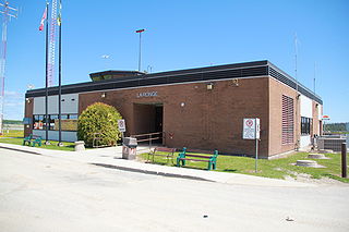
La Ronge Airport is located 2 nautical miles northeast of La Ronge, Saskatchewan, Canada.
Lumsden (Metz) Airport, formerly TC LID: CKR5\, was located 6 NM north-west of Lumsden, Saskatchewan, Canada.
Paradise Hill Airport(TC LID: CJE6) was located adjacent to Paradise Hill, Saskatchewan, Canada.

Stony Rapids Airport is located adjacent to Stony Rapids, Saskatchewan, Canada.
White City (Radomsky) Airport, formerly TC LID: CWC1, is located 1.5 nautical miles east of White City, Saskatchewan, Canada.
Yorkton Municipal Airport is located 2.8 nautical miles north of Yorkton, Saskatchewan, Canada.
Hatchet Lake Airport is located near Hatchet Lake, Saskatchewan, Canada.
Cabri is a town in southwestern Saskatchewan directly north of Gull Lake, northwest of Swift Current and east of the Great Sand Hills. It was incorporated as a village in 1912 and as a town in 1917.

The Rural Municipality of Arborfield No. 456 is a rural municipality (RM) in the Canadian province of Saskatchewan within Census Division No. 14 and SARM Division No. 4.
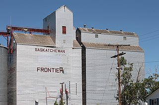
Frontier is a village in the Canadian province of Saskatchewan within the Rural Municipality of Frontier No. 19 and Census Division No. 4. Frontier is on Highway 18 and is served by the Frontier Airport located (3.7 km) south of the village.
Axe Lake Aerodrome is located near the Axe Lake oil sands discovery in north-west Saskatchewan, Canada. The aerodrome is located near the border with Alberta, just south of Vande Veen Lake. The nearest highway is Highway 955 to the east. A gravel road connects the airport to the highway.
The Rural Municipality of Riverside No. 168 is a rural municipality (RM) in the Canadian province of Saskatchewan within Census Division No. 8 and SARM Division No. 3.
Seabee Mine Aerodrome is located near Laonil Lake and serves the Seabee Gold Mine in Saskatchewan, Canada.

