Camp Robber Peak

Last updated
Camp Robber Peak
Camp Robber Peak.jpg
Camp Robber Peak, southwest aspect
Highest point
Elevation 6,286 ft (1,916 m) [1] [2]
Prominence 1,206 ft (368 m) [1]
Parent peak Wild Goat Peak (6,305 ft) [3]
Isolation 1.31 mi (2.11 km) [3]
Coordinates 47°34′16″N121°19′55″W / 47.571167°N 121.331948°W / 47.571167; -121.331948 [1]
Geography
USA Washington relief location map.jpg
Red triangle with thick white border.svg
Camp Robber Peak
Location in Washington
Usa edcp relief location map.png
Red triangle with thick white border.svg
Camp Robber Peak
Camp Robber Peak (the United States)
Location King County
Washington state, U.S.
Parent range Cascade Range
Topo map USGS Big Snow Mountain
Climbing
Easiest route class 3 scrambling. [4]

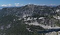
Camp Robber Peak is a 6,286-foot (1,916-metre) mountain summit located above the western shore of Big Heart Lake, in eastern King County of Washington state. It's part of the Cascade Range, and is situated in the Alpine Lakes Wilderness, on land managed by Mount Baker-Snoqualmie National Forest. Precipitation runoff from the mountain drains into Camp Robber Creek and Foss River, both tributaries of the Skykomish River. This peak's name is derived from Camp Robber Creek and Camp Robber Lake, which lie in Camp Robber Valley to the northwest of the peak. [5] "Camp robber" is the colloquial name for several North American species of birds known for their fearlessness around humans and their proclivity for stealing food from campers. The nearest higher neighbor is Wild Goat Peak, 1.3 mi (2.1 km) to the south. [1]

Contents

Climate

Camp Robber Peak is located in the marine west coast climate zone of western North America. [2] Most weather fronts originate in the Pacific Ocean, and travel northeast toward the Cascade Mountains. As fronts approach, they are forced upward by the peaks of the Cascade Range, causing them to drop their moisture in the form of rain or snowfall onto the Cascades (Orographic lift). As a result, the west side of the Cascades experiences high precipitation, especially during the winter months in the form of snowfall. During winter months, weather is usually cloudy, but, due to high pressure systems over the Pacific Ocean that intensify during summer months, there is often little or no cloud cover during the summer. [2] Because of maritime influence, snow tends to be wet and heavy, resulting in avalanche danger. [2]

Geology

The Alpine Lakes Wilderness features some of the most rugged topography in the Cascade Range with craggy peaks and ridges, deep glacial valleys, and granite walls spotted with over 700 mountain lakes. [6] Geological events occurring many years ago created the diverse topography and drastic elevation changes over the Cascade Range leading to the various climate differences.

The history of the formation of the Cascade Mountains dates back millions of years ago to the late Eocene Epoch. [7] With the North American Plate overriding the Pacific Plate, episodes of volcanic igneous activity persisted. [7] In addition, small fragments of the oceanic and continental lithosphere called terranes created the North Cascades about 50 million years ago. [7]

During the Pleistocene period dating back over two million years ago, glaciation advancing and retreating repeatedly scoured and shaped the landscape. [7] The last glacial retreat in the Alpine Lakes area began about 14,000 years ago and was north of the Canada–US border by 10,000 years ago. [7] The U-shaped cross section of the river valleys is a result of that recent glaciation. Uplift and faulting in combination with glaciation have been the dominant processes which have created the tall peaks and deep valleys of the Alpine Lakes Wilderness area.

See also

Camp Robber Peak Camp Robber Peak crop.jpg
Camp Robber Peak

Related Research Articles

<span class="mw-page-title-main">Red Mountain (King County, Washington)</span> Mountain in Washington (state), United States

Red Mountain is a 5,890-foot (1,800-metre) mountain summit located in King County of Washington state. It is set within the Alpine Lakes Wilderness which is part of the Cascade Range. Red Mountain is situated three miles north of Snoqualmie Pass on land managed by Mount Baker-Snoqualmie National Forest. The nearest higher neighbor is Lundin Peak, 0.7 mi (1.1 km) to the northwest. Precipitation runoff on the north side of the mountain drains into Middle Fork of the Snoqualmie River, whereas the south side of the mountain drains into the South Fork Snoqualmie River via Commonwealth Creek.

<span class="mw-page-title-main">Chair Peak (Washington)</span> Mountain in Washington (state), United States

Chair Peak is a 6,238 ft (1,900 m) mountain summit located in east King County of Washington state. It's part of the Cascade Range and is set within the Alpine Lakes Wilderness. Chair Peak is situated three miles northwest of Snoqualmie Pass on land managed by Mount Baker-Snoqualmie National Forest. Precipitation runoff from this mountain drains into tributaries of the Snoqualmie River. Chair Peak is located immediately south of Snow Lake which is a popular hiking destination. The nearest higher neighbor is Kaleetan Peak, 0.57 miles (0.92 km) to the west-northwest.

<span class="mw-page-title-main">Kaleetan Peak</span> Mountain in Washington (state), United States

Kaleetan Peak is a prominent 6,259-foot (1,908-metre) mountain summit located in King County of Washington state. It's part of the Cascade Range and is within the Alpine Lakes Wilderness. Kaleetan Peak is situated four miles northwest of Snoqualmie Pass on land managed by Mount Baker-Snoqualmie National Forest. It's immediately west of Melakwa Pass and Chair Peak, and north of Melakwa Lake. Precipitation runoff on the mountain drains into tributaries of the Snoqualmie River. The nearest higher peak is Snoqualmie Mountain, 2.89 miles (4.65 km) to the east. The mountain's name "Kaleetan" derives from Chinook Jargon which means "arrow".

<span class="mw-page-title-main">Lundin Peak</span> Mountain in Washington (state), United States

Lundin Peak is a summit located in King County of Washington state. It's part of the Cascade Range and is within the Alpine Lakes Wilderness. Lundin Peak is situated three miles north of Snoqualmie Pass on land managed by Mount Baker-Snoqualmie National Forest. Originally called Snoqualmie Little Sister, the peak's name was changed in 1931 to honor district forest ranger John Lundin. Lundin Peak is a high point on a ridge located midway between Snoqualmie Mountain and Red Mountain. Precipitation runoff from the mountain drains into tributaries of the Snoqualmie River.

<span class="mw-page-title-main">McClellan Peak</span> Mountain in Washington (state), United States

McClellan Peak is an 8,364 ft summit located in Chelan County of Washington state. Its name honors Army explorer George B. McClellan who visited the area in 1853. McClellan Peak forms part of the south rim of The Enchantments lake basin within the Alpine Lakes Wilderness, and it belongs to the Stuart Range which is subset of the Cascade Range. McClellan Peak is situated 1.29 miles east of Little Annapurna which is its nearest higher neighbor. Precipitation runoff drains into tributaries of the Wenatchee River.

<span class="mw-page-title-main">Bryant Peak</span> Mountain in Washington (state), United States

Bryant Peak is a 5,801 ft (1,770 m) summit located in King County of Washington state. It's part of the Cascade Range and is within the Alpine Lakes Wilderness. Bryant Peak is located northwest of Snoqualmie Pass and the Alpental ski area, on land managed by Mount Baker-Snoqualmie National Forest. Bryant Peak is located south of Snow Lake which is a popular hiking destination. The nearest higher neighbor is Chair Peak, 0.65 miles (1.05 km) to the northwest. Originally called Hemlock Peak, Bryant Peak was renamed in 1925 to honor Sidney V. Bryant of The Mountaineers who made the first ascent of Kaleetan Peak in 1914. Precipitation runoff from the mountain drains into tributaries of the Snoqualmie River.

<span class="mw-page-title-main">The Tooth (Washington)</span> Peak in the Cascade Range

The Tooth is the descriptive name for a 5,604 ft, fin-like, andesite pillar located in King County of Washington state. It is part of the Cascade Range and is within the Alpine Lakes Wilderness. The Tooth is located northwest of Snoqualmie Pass and the Alpental ski area on land managed by Mount Baker-Snoqualmie National Forest. The nearest higher peak is Bryant Peak, 0.44 miles (0.71 km) to the northwest. Originally called Denny Horn and Denny Tooth, The Tooth became the officially recognized name in 1918, with Denny referring to its position on the high ridge between Denny Mountain and Chair Peak. The Tooth is a popular rock climbing destination, even in winter. The easiest route is class 4 scrambling, but solid rock provides technical routes, with the South Face considered a classic 5.4 climb that was first done in 1928 by Anderson and Wunderling.

<span class="mw-page-title-main">Preacher Mountain</span> Mountain in Washington (state), United States

Preacher Mountain is a broad summit located in King County of Washington state. It's located at the western edge of the Cascade Range and is within the Alpine Lakes Wilderness on land managed by Mount Baker-Snoqualmie National Forest. The nearest higher peak is Kaleetan Peak, 3.11 miles (5.01 km) to the southeast. The Pulpit is situated 2.19 miles to the northwest. Precipitation runoff from the mountain drains into tributaries of the Snoqualmie River.

<span class="mw-page-title-main">Summit Chief Mountain</span> Mountain in Washington (state), United States

Summit Chief Mountain is a 7,464-foot (2,275-meter) mountain summit located on the county line separating King County and Kittitas County in Washington state. It is entirely within the Alpine Lakes Wilderness, on land managed by Mount Baker-Snoqualmie National Forest. Summit Chief Mountain is situated on the crest of the Cascade Range, nine miles northeast of Snoqualmie Pass. Precipitation runoff from the west side of the mountain drains into tributaries of the Snoqualmie River, whereas the east side drains into tributaries of the Yakima River. The nearest higher peak is Chimney Rock, 1.29 miles (2.08 km) to the southwest.

<span class="mw-page-title-main">Mount Defiance (Washington)</span> Mountain in Washington (state), United States

Mount Defiance is a 5,584-foot (1,702-metre) mountain summit located in King County of Washington state. It's part of the Cascade Range and is within the Alpine Lakes Wilderness. Mount Defiance is situated 6.5 mi (10.5 km) west of Snoqualmie Pass on land managed by Mount Baker-Snoqualmie National Forest. Precipitation runoff on the mountain drains into tributaries of the Snoqualmie River. The nearest higher peak is Granite Mountain, 3.96 mi (6.37 km) to the east-southeast, and Bandera Mountain is 1.85 mi (2.98 km) to the southeast. Mount Defiance can be reached by trail, with access via the Ira Spring, Talapus Lake, or Pratt Lake trailheads.

<span class="mw-page-title-main">Mount Thomson</span> Mountain in Washington (state), United States

Mount Thomson is a prominent 6,554-foot-elevation (1,998-meter) mountain summit in eastern King County of Washington state.

<span class="mw-page-title-main">Big Snow Mountain</span> Mountain summit of the Cascade Range in King County, Washington State

Big Snow Mountain is a prominent 6,680-foot (2,040-metre) mountain summit located 7 mi (11 km) north of Snoqualmie Pass in the Alpine Lakes Wilderness in eastern King County of Washington state. It is part of the Cascade Range and is situated on land managed by Mount Baker-Snoqualmie National Forest. Precipitation runoff from the mountain drains into tributaries of the Snoqualmie and Skykomish Rivers. The nearest higher peak is Overcoat Peak, 3.75 mi (6.04 km) to the east-southeast.

<span class="mw-page-title-main">Mount Roosevelt</span> Mountain in Washington (state), United States

Mount Roosevelt is a 5,835-foot (1,779-metre) mountain summit located 6 mi (10 km) northwest of Snoqualmie Pass, in east King County of Washington state. It's part of the Cascade Range and is situated within the Alpine Lakes Wilderness, on land managed by Mount Baker-Snoqualmie National Forest. Mount Roosevelt is set above the western shore of Snow Lake, and 2 mi (3 km) immediately north of Kaleetan Peak, which is its nearest higher neighbor. Precipitation runoff from the mountain drains into tributaries of the Snoqualmie River. This mountain's name was officially adopted in 1989 by the U.S. Board on Geographic Names.

<span class="mw-page-title-main">Malachite Peak</span> Mountain in Washington (state), United States

Malachite Peak is a 6,261-foot (1,908-metre) mountain summit located 5.5 mi (8.9 km) south of Skykomish, in eastern King County of Washington state. It's part of the Cascade Range, and is situated one mile north of Lake Malachite in the Alpine Lakes Wilderness, on land managed by Mount Baker-Snoqualmie National Forest. Precipitation runoff from the mountain drains into tributaries of the Skykomish River. The nearest higher neighbor is Camp Robber Peak, 3.66 mi (5.89 km) to the south. The first ascent of this peak may have been in 1937 by a team from the United States Geological Survey. The USGS named the peak about 1975 based on a triangulation station marked as "Malachite".

<span class="mw-page-title-main">Wild Goat Peak</span> Mountain in Washington (state), United States

Wild Goat Peak is a 6,305-foot (1,922-metre) mountain summit located above the eastern shore of Gold Lake, in eastern King County of Washington state. It's part of the Cascade Range, and is situated in the Alpine Lakes Wilderness, on land managed by Mount Baker-Snoqualmie National Forest. Precipitation runoff from the mountain drains into tributaries of the Snoqualmie and Skykomish Rivers. The nearest higher neighbor is Big Snow Mountain, 1.91 mi (3.07 km) to the southwest. This peak was once called "Big Snowy".

<span class="mw-page-title-main">Little Big Chief Mountain</span> Mountain in Washington

Little Big Chief Mountain is a 7,225-foot (2,202-metre) mountain summit located immediately southwest of Dutch Miller Gap, on the common border separating King County and Kittitas County in Washington state. It is situated within the Alpine Lakes Wilderness, on land managed by Mount Baker-Snoqualmie National Forest. Little Big Chief Mountain is set ten miles northeast of Snoqualmie Pass on the crest of the Cascade Range. Precipitation runoff from the west side of the mountain drains into tributaries of the Snoqualmie River, whereas the east side drains into tributaries of the Yakima River. The nearest higher peak is Summit Chief Mountain, 0.7 miles (1.1 km) to the southwest, and Chimney Rock is set 2.2 miles (3.5 km) to the southwest. The first ascent of this peak was made in August 1939 by Fred Beckey, Wayne Swift, Joe Barto, and Campbell Brooks. This mountain was named for Lorenz A. Nelson during the 1925 Mountaineers climb of Summit Chief Mountain. Nelson was a pioneering mountaineer who led first ascents of Mount Olympus, Mount Meany, and Chiwawa Mountain.

<span class="mw-page-title-main">Thunder Mountain (Washington)</span> Mountain in Washington (state), United States

Thunder Mountain is a 6,556-foot (1,998-metre) mountain summit located above the eastern shore of Glacier Lake, on the common border of King County and Chelan County in Washington state. It's part of the Wenatchee Mountains, which are a subset of the Cascade Range, and is situated in the Alpine Lakes Wilderness, on land managed by Mount Baker-Snoqualmie National Forest. Precipitation runoff from the mountain drains west into Surprise Creek, or east into tributaries of Icicle Creek. The nearest higher neighbor is Nimbus Mountain, 0.56 mi (0.90 km) to the northeast, and Surprise Mountain is set 0.88 mi (1.42 km) to the southwest. The Pacific Crest Trail skirts this peak as it passes between Thunder Mountain and Spark Plug Mountain.

<span class="mw-page-title-main">Burnt Boot Peak</span> Mountain in Washington (state), United States

Burnt Boot Peak is a 6,520+ ft mountain summit located in the Alpine Lakes Wilderness in eastern King County of Washington state. The peak is part of the Cascade Range and is one mile east of the crest of the range. Burnt Boot Peak is situated 6.5 mi (10.5 km) northeast of Snoqualmie Pass on land managed by Mount Baker-Snoqualmie National Forest. Huckleberry Mountain is set 1.87 mi (3.01 km) to the south, and the nearest higher neighbor is Lemah Mountain, 1.34 mi (2.16 km) to the east. This unofficially-named mountain is located at the head of the officially-named Burnboot Creek, variant spelling Burntboot Creek. Precipitation runoff from the mountain drains south into this creek, or north into Middle Fork Snoqualmie River. The first ascent of this peak was made in August 1963 by Phil Weiser and Clarke Stockwell. The first ascent via the north ridge route was made in June 1971 by Don Williamson, Tom Oas, and Bill Bucher.

<span class="mw-page-title-main">Wright Mountain</span> Mountain in Washington (state), United States

Wright Mountain is a 5,430-foot-elevation mountain summit located 11 mi (18 km) northwest of Snoqualmie Pass, in east King County of Washington state. It is part of the Cascade Range and is situated within the Alpine Lakes Wilderness, on land managed by Mount Baker-Snoqualmie National Forest. Wright Mountain is set above the northern shore of Gem Lake, and less than one mile north-northwest of Snow Lake. Neighbors within two miles include Kaleetan Peak, Chair Peak, and Mount Roosevelt, which is its nearest higher neighbor. Precipitation runoff from the mountain drains into tributaries of the Snoqualmie River. This mountain's name was officially proposed as Mount Wright in 1925 by The Mountaineers, and amended to Wright Mountain in 1968 by the U.S. Board on Geographic Names, to commemorate George E. Wright, a prominent Seattle attorney and mountaineer who was active in establishing Olympic National Park. Wright died October 9, 1923.

<span class="mw-page-title-main">Dip Top Peak</span> Mountain in Washington (state), United States

Dip Top Peak is a 7,291-foot-elevation mountain summit located in the Alpine Lakes Wilderness in eastern King County of Washington state. It is part of the Cascade Range and is set on land managed by Mount Baker-Snoqualmie National Forest. The peak is situated 1.25 mi (2.01 km) north of Mount Daniel, and less than one mile south of Jade Lake. Precipitation runoff from the mountain drains into East Fork Foss River, which is a tributary of the Skykomish River. The summit saddle has two rock horns, of which the higher southwest peak is the true summit. The first ascent was made August 1950 by Bill and Gene Prater. In the early 1970s, brothers Gene and Bill Prater created the modern aluminum snowshoe known today, and sold them via Bill's "Sherpa Snowshoes" company, which proved very popular.

References

  1. 1 2 3 4 "Camp Robber Peak, Washington". Peakbagger.com.
  2. 1 2 3 4 Beckey, Fred W. Cascade Alpine Guide, Climbing and High Routes. Seattle, WA: Mountaineers Books, 2008.
  3. 1 2 "Camp Robber Peak - 6,286' WA". listsofjohn.com. Retrieved 2020-06-22.
  4. Goldman, Peggy. Washington Scrambles, 2nd Ed., The Mountaineers Books, 2014
  5. "Camp Robber Peak Washington". Bivouac.com. Retrieved 2020-06-22.
  6. Smoot, Jeff (2004). Backpacking Washington's Alpine Lakes Wilderness. Helena, Montana: The Globe Pequot Press.
  7. 1 2 3 4 5 Kruckeberg, Arthur (1991). The Natural History of Puget Sound Country. University of Washington Press.