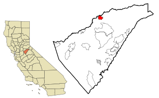
Angels Camp, also known as City of Angels and formerly Angel's Camp, Angels, Angels City, Carson's Creek and Clearlake, is the only incorporated city in Calaveras County, California, United States. The population was 3,150 at the 2010 census, up from 3,004 at the 2000 census. It lies at an elevation of 1378 feet.
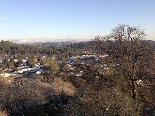
Murphys, originally Murphys New Diggings then Murphy's Camp, is an unincorporated village located in the foothills of the Sierra Nevada mountains in Calaveras County, California, United States. A former gold mining settlement, the main street today is lined with over two dozen wine tasting rooms and surrounded by local vineyards. The town is popular among tourists and transplants from the Central Valley and the San Francisco Bay Area. Murphys is also known by its colloquial nickname as "Queen of the Sierra" and is one of the more affluent communities in Calaveras County.
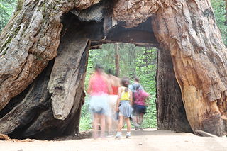
Calaveras Big Trees State Park is a state park of California, United States, preserving two groves of giant sequoia trees. It is located 4 miles (6.4 km) northeast of Arnold, California in the middle elevations of the Sierra Nevada. It has been a major tourist attraction since 1852, when the existence of the trees was first widely reported, and is considered the longest continuously operated tourist facility in California.

"The Celebrated Jumping Frog of Calaveras County" is an 1865 short story by Mark Twain. It was his first great success as a writer and brought him national attention. The story has also been published as "Jim Smiley and His Jumping Frog" and "The Notorious Jumping Frog of Calaveras County". In it, the narrator retells a story he heard from a bartender, Simon Wheeler, at the Angels Hotel in Angels Camp, California, about the gambler Jim Smiley. The narrator describes him: "If he even seen a straddle bug start to go anywheres, he would bet you how long it would take him to get to wherever he going to, and if you took him up, he would foller that straddle bug to Mexico but what he would find out where he was bound for and how long he was on the road."

The Shores of Poker Flat is an unincorporated community in Calaveras County, California. It lies at an elevation of 584 feet above sea level and is located at 37°54′11″N120°34′56″W, on the shore of the Tulloch Reservoir. The community is in ZIP code 95228 and area code 209.
Altaville is a former unincorporated community in Calaveras County, California, now located in the northwest portion of the city of Angels Camp. It sits at an elevation of 1,542 feet above sea level and is located at 38°05′02″N120°33′43″W, at the intersections of SR 49 and SR 4. The community is in ZIP code 95221 and area code 209.

The Calaveras River is a river in the San Joaquin Valley of California.
New Hogan Lake is an artificial lake in the foothills of the Sierra Nevada in Calaveras County, California, about 30 miles (48.3 km) northeast of Stockton. It is formed by New Hogan Dam on the Calaveras River, whose North and South forks combine just upstream of the lake, and has a capacity of 317,000 acre⋅ft (391,000,000 m3). The earth-fill dam, completed in 1963, is 210 feet (64.0 m) high from the crest of the dam to the original streambed. The reservoir was first filled in 1965. There is a small hydroelectric plant at its base. It is owned by the United States Army Corps of Engineers and provides flood protection, drinking water, electricity and water for irrigation. There is also recreation available, such as boating, fishing, water skiing and camping. It has recently become a dump for people from the city to come and drop off their trash.

The Greater Yosemite Council (#059) is a local council of the Boy Scouts of America based in Modesto, California. It was founded in 1920 as the Modesto Council. In 1921 Modesto changed its name to the Stanislaus County Council, and in 1922 to the Yosemite Area. In 1998, the council changed its name to the Greater Yosemite Council. In 1997, the Forty Niner Council (#052) merged with the Yosemite Area Council.
Big Bar is an unincorporated community in Calaveras County, California. It lies at an elevation of 630 feet.
Camp Connell is an unincorporated community in Calaveras County, California. It lies at an elevation of 4760 feet. The first post office was established in 1934 and landowner John F. Connell was appointed first postmaster; the place is named after him.
Camp Pardee is an unincorporated East Bay MUD company town for the operators of Pardee Dam. It is located in Calaveras County, California, near Pardee Reservoir. It lies at an elevation of 696 feet and is home to 35 people.
Carmen City is an unincorporated community in Calaveras County, California. It lies on the east side of the Salt Spring Valley about 8 miles (13 km) west-southwest of Angels Camp, at an elevation of 1266 feet.
Felix is an unincorporated community in Calaveras County, California, in Salt Spring Valley 9.5 miles (15.3 km) west-southwest of Angels Camp. It lies at an elevation of 1115 feet. A post office operated here from 1896 to 1923.
Lost City is an unincorporated community in Calaveras County, California, 11 miles (18 km) from Angels Camp along Bear Creek. It lies at an elevation of 1053 feet. Lost City was constructed in the 1870s by Eugene Barbe. It consists of roughly one dozen stone buildings, which may have been an early Icarian commune. The settlement was abandoned by 1896, though a few walls of the original dry-laid field stone buildings remain. The ruins are currently on private land.
White Pines is an unincorporated community in Calaveras County, California. It lies at an elevation of 3907 feet. In the 1940s, White Pines was a lumber camp. A post office operated here from 1940 to 1975.
Brownsville is a former settlement in Calaveras County, California, about 1 mile east of Murphys. Brownsville, named for Alfred Brown, operated as a mining camp in the 1850s and 1860s.
Greasertown is a former settlement in Calaveras County, 4 miles (6.4 km) west of San Andreas, on the west side of the Calaveras River. The town was rumored to have received its name due to what one-time resident and schoolteacher Margaret Blanc described as “a straggling settlement … with canvas tents and wooden shanties of which it consisted the abodes of … Mexicans who packed and drove mules up to the mines with provisions for the diggers at work on the banks on the Mokelumne and Calaveras.” Blanc said the town was in fact diverse, with many nationalities represented. She wrote that the town included, “About 30 children made up of all classes, nationalities and ages.”
Yaqui Camp is a former settlement in Calaveras County, 2 miles (3.2 km) southeast of San Andreas, on Willow Creek.