Campolongo al Torre

Last updated • 6 min readFrom Wikipedia, The Free Encyclopedia
Campolongo al Torre
Italy provincial location map 2016.svg
Red pog.svg
Campolongo al Torre
Location of Campolongo al Torre in Italy
Coordinates: 45°52′N13°23′E / 45.867°N 13.383°E / 45.867; 13.383
CountryItaly
Region Friuli-Venezia Giulia
Province Province of Udine (UD)
Comune Campolongo Tapogliano
Area
  Total5.9 km2 (2.3 sq mi)
Elevation
16 m (52 ft)
Population
 (2007) [1]
  Total775
  Density130/km2 (340/sq mi)
Demonym Campolonghesi
Time zone UTC+1 (CET)
  Summer (DST) UTC+2 (CEST)
Postal code
33040
Dialing code 0431
Patron saint San Rocco
Saint day16 August

Campolongo al Torre (Friulian : Cjamplunc) is a former comune of the Province of Udine in the Italian region Friuli-Venezia Giulia, located about 40 km northwest of Trieste and about 25 km southeast of Udine. Since 2009 it has been one of the two principal centres of Campolongo Tapogliano, a municipality formed by its merger with the former comune of Tapogliano.

Contents

History

Ancient era

The lands near Campolongo appear to have been settled dating back to Roman times. The first mention dates to the nearby town of Tapogliano. Gravestones, bearing Latin inscriptions which indicate that name of the nearby town derives from the Latin "Tappulius (Tappulus)", a possible Roman assignee of these lands. [2] That settlement is probably a consequence to that of the establishment of Aquileia (ca. 180 BC). These settlements served as strategic frontier outposts at the north-east corner of the Italian peninsula, intended to protect the Veneti, allies of Rome at that time. In the next centuries the Roman roads of Via Postumia, Via Popilia, Via Gemina and Via Annia would link the area to the rest of the Italian peninsula and beyond.

Middle Ages

The area was devastated in the fifth century by Germanic and other invasions by Alaric I and Attila. The Roman inhabitants fled en masse to the lagoons, in Veneti and so laid the foundations of the city of Venice. Then the Lombards wasted the countryside a second time in 590 but also establishing the Duchy of Friuli in the vicinity. Lombards ruled until 774, when Charlemagne conquered the Friuli and made it into a Frankish state under Eric of Friuli.

Under Charlemagne the new Patriarchate of Aquileia was established. The patriarchate would become one of the largest dioceses. However, in the 10th century, the Friuli area would suffer under the raids of the Magyars, which would contribute to the decline of imperial control and increase the authority of the patriarchs. By the 11th century, the patriarch of Aquileia had grown strong enough to assert temporal sovereignty over Friuli and Aquileia and the Holy Roman Emperor Henry IV gave the region to the patriarch as a feudal possession albeit constantly disputed by the territorial nobility. In the 14th century the Patriarchal State known as the Patria del Friuli reached its largest extension, stretching from the Piave river to the Julian Alps and northern Istria. The seat of the Patriarchate of Aquileia had been transferred first to Cividale and then in 1238 to Udine.

It was during this time that the name of Campolongo is encountered for the first time in a note relating to March 1327: [3] "Taxes collected by the Aquileia on the massari (farmers/settlers) of Carripa and Dapiferato, on the beheast of the Patriarch, as they are shown in the following note in Budrio, Orasaria, Campolongo and Visco, San Pietro d'Isonzo ...". Thus in 1327 in Campolongo there were "massari" subject to the Patriarch of Aquileia. Then the documents are silent for a period.

However, Friuli had to cope with the rising naval power of the Republic of Venice. Since the transfer of the patriarchal residence to Udine, the Venetians and the Patriarchate engaged in political and physical warfare. From about 1400, Venice began to enlarge its influence by occupying Aquileia/Friulian territory. By 1411 this turned into a war which was to mark the end of the Patriarchate. In December an Imperial army captured Udine; in 1419 the Venetians conquered Cividale; and, then Gemona, San Daniele, Venzone and Tolmezzo followed. The former Patriarchate territories were secularized by Venice and under the Domini di Terraferma, the territories stretching from the Adriatic Sea to the Alps, were ceded to the Republic.

Campolongo was thus ruled by the Republic of Venice in 1420. [4] Campolongo was administered by its own degani and by Venetian "notaries". Friuli maintained a form of autonomy, by keeping its own Parliament ruling on the old territory of the Patriarchate; it also maintained its feudal nobility, which was able to keep their feudal rights over the land and its inhabitants for some time. Venice exploited the Friulian lands. The harvesting of timber needed to build Venetian ships caused complete deforestation of the lower and central Friuli. Venice took also possession of collective farms belonging to rural Friulian communities, seriously impoverishing them.

San Giorgio Martire, constructed between 1696 and 1736 Glesie di Cjamplunc.jpg
San Giorgio Martire, constructed between 1696 and 1736

Beginning in 1516 the Habsburg Empire controlled eastern Friuli, while western and central Friuli was Venetian. Campolongo and Tapogliano then, wedged between the Austrian archducal territory, often felt the weight of foreign incursions, which Austria then instigated or nurtured, so much so that: "... the twentieth first of May 1616 some (archducal) forces, stopping outside Gradisca, sacked the villa of Campolongo, highly esteemed by the Venetians". [5]

In another circumstance Campolongo was put on fire and according to the chronicle of the town leaders (catapano), the priest was killed, the parsonage burned and grains and livestock were removed from the country. [5]

Modern age

Austrian rule

Campolongo remained under Venetian rule until the fall of Venice, that is, from the year 1420 to 1797. That year under the Treaty of Campo Formio, this part of the Friuli became part of Austria. For a brief period from 1805 until the Bourbon Restoration (Congress of Vienna), Friuli belonged to the Italic Kingdom under Napoleon.

Austrian Kustenland Litorale austriaco 1897.jpg
Austrian Küstenland

The Ethnographic map of Karl von Czoernig-Czernhausen, issued by the Imperial Administration of Statistics in 1855, recorded a total of over 400 thousand Friulians living in the Austrian Empire. The majority of Friulians (about 351 thousand) lived in that part of Friuli that belonged to the Kingdom of Lombardy–Venetia, the others in the Friulian parts of the Austrian Küstenland. Friulians were registered as their own category separate from Italians.

Küstenland (or the Austrian Littoral) was officially Triest Province, one of two provinces (or governments) of the Empire, the other being Laibach (Ljubljana in Slovenia). It was further divided into four districts or kreis: 1) Görz or Gorizia including the Julian March (Include Campolongo), 2) Istrien or Istria, Eastern Istria and the Quarnero Islands, 3) Triest or Trieste; the Trieste hinterland and Western Istria, and 4) Trieste city.

Around 1825, the province was reorganized into two subdivisions: 1) Istria and 2) Gorizia (includes Campolongo) with Trieste and its immediate surroundings under the direct control of the crown and separate from the local administrative structure.

In 1849, Küstenland became a separate crown land with a governor in Trieste. It was formally divided into Istria and Gorizia and Gradisca (includes Campolongo) with Trieste remaining separate from both.

By 1861, Gorizia and Gradisca (includes Campolongo) and Istria became administratively separate entities and, in 1867, Trieste received separate status as well, and the Küstenland was divided into the three crown lands of the Imperial Free City of Trieste and its suburbs, the Margraviate of Istria, and the Princely County of Gorizia and Gradisca (includes Campolongo), which each had separate administrations and Landtag assemblies, but were all subject to a statholder at Trieste.

During the Third War of Independence in 1866, Campolongo saw the location of the last action between the Kingdoms of Italy and Austria. On July 26, a mixed Italian force of bersaglieri and cavalry defeated an Austrian force guarding the crossing of the Torre river and reached present-day Romans d'Isonzo in the Battle of Versa. This marked the maximum Italian advance into Friuli. Under the Treaty of Vienna (1866), Central Friuli (today's province of Udine) and western Friuli (today's province of Pordenone) were annexed by Italy together with Veneto after this war, while eastern Friuli (County of Gorizia and Gradisca, including Campolongo) remained under Austria. This division helped in part to give rise to "Italia irredenta".

Demographic evolution

Campolongo al Torre

Related Research Articles

<span class="mw-page-title-main">Aquileia</span> Comune in Friuli-Venezia Giulia, Italy

Aquileia is an ancient Roman city in Italy, at the head of the Adriatic at the edge of the lagoons, about 10 kilometres (6 mi) from the sea, on the river Natiso, the course of which has changed somewhat since Roman times. Today, the city is small, but it was large and prominent in classical antiquity as one of the world's largest cities with a population of 100,000 in the second century AD and is one of the main archaeological sites of northern Italy. In late antiquity the city was the first city in the Italian Peninsula to be sacked by Attila the Hun.

<span class="mw-page-title-main">Friuli-Venezia Giulia</span> Autonomous region of Italy

Friuli-Venezia Giulia is one of the 20 regions of Italy and one of five autonomous regions with special statute. The regional capital is Trieste on the Gulf of Trieste, a bay of the Adriatic Sea.

<span class="mw-page-title-main">Friuli</span> Historical region in northeast Italy

Friuli is a historical region of northeast Italy. The region is marked by its separate regional and ethnic identity predominantly tied to the Friulians, who speak the Friulian language. It comprises the major part of the autonomous region Friuli-Venezia Giulia, i.e. the administrative provinces of Udine, Pordenone, and Gorizia, excluding Trieste.

<span class="mw-page-title-main">Gorizia</span> Comune in Friuli-Venezia Giulia, Italy

Gorizia, colloquially stara Gorica 'old Gorizia' to distinguish it from Nova Gorica, is a town and comune (municipality) in northeastern Italy, in the autonomous region of Friuli-Venezia Giulia. It is located at the foot of the Julian Alps, bordering Slovenia. It is the capital of the Regional decentralization entity of Gorizia and is a local center of tourism, industry, and commerce. Since 1947, a twin town of Nova Gorica has developed on the other side of the modern-day Italy–Slovenia border. The region was subject to territorial dispute between Italy and Yugoslavia after World War II: after the new boundaries were established in 1947 and the old town was left to Italy, Nova Gorica was built on the Yugoslav side. The two towns constitute a conurbation, which also includes the Slovenian municipality of Šempeter-Vrtojba. Since May 2011, these three towns have been joined in a common trans-border metropolitan zone, administered by a joint administration board.

<span class="mw-page-title-main">Gradisca d'Isonzo</span> Comune in Friuli-Venezia Giulia, Italy

Gradisca d'Isonzo is a town and comune (municipality) in the Regional decentralization entity of Gorizia in Friuli-Venezia Giulia, north-eastern Italy. The lawyer, linguist, philologist Philippe Sarchi was born in Gradisca d'Isonzo. It is one of I Borghi più belli d'Italia.

<span class="mw-page-title-main">Province of Udine</span> Province of Italy

The province of Udine was a province in the autonomous Friuli-Venezia Giulia region of Italy, bordering Austria and Slovenia, with the capital in the city of Udine. Abolished on 30 September 2017, it was reestablished in 2019 as the Regional Decentralization Entity of Udine, and was reactivated on 1 July 2020. It has a population of 530,849 inhabitants over an area of 4,907.24 square kilometres (1,894.70 sq mi).

<span class="mw-page-title-main">Julian March</span> Historical region in Croatia, Italy, and Slovenia

The Julian March, also called Julian Venetia, is an area of southern Central Europe which is currently divided among Croatia, Italy, and Slovenia. The term was coined in 1863 by the Italian linguist Graziadio Isaia Ascoli, a native of the area, to demonstrate that the Austrian Littoral, Veneto, Friuli, and Trentino shared a common Italian linguistic identity. Ascoli emphasized the Augustan partition of Roman Italy at the beginning of the Empire, when Venetia et Histria was Regio X.

<span class="mw-page-title-main">Grado, Friuli Venezia Giulia</span> Comune in Friuli-Venezia Giulia, Italy

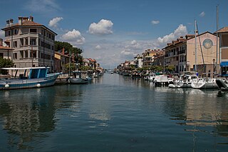
Grado is a town and comune (municipality) of 8,064 residents in the Regional decentralization entity of Gorizia in the north-eastern Italian region of Friuli-Venezia Giulia, located on an island and adjacent peninsula of the Adriatic Sea between Venice and Trieste. The territory of the municipality of Grado extends between the mouth of the Isonzo and the Adriatic Sea and the Grado Lagoon, and covers an area of about 90 square kilometers between Porto Buso and Fossalon. Characteristic of the lagoon is the presence of the casoni, which are simple houses with thatched roof used in the past by the fishermen of Grado, who remained in the lagoon for a long time, returning to the island of Grado only during the colder period of the year.

<span class="mw-page-title-main">Monfalcone</span> Comune in Friuli-Venezia Giulia, Italy

Monfalcone is a town and comune (municipality) in the Regional decentralization entity of Gorizia in Friuli-Venezia Giulia, northern Italy, located on the Gulf of Trieste. Its name means 'falcon mountain'.

<span class="mw-page-title-main">Austrian Littoral</span> Former crown land of the Austrian Empire

The Austrian Littoral was a crown land (Kronland) of the Austrian Empire, established in 1849. It consisted of three regions: the Margraviate of Istria in the south, Gorizia and Gradisca in the north, and the Imperial Free City of Trieste in the middle. The region has been contested frequently, with parts of it controlled at various times by the Republic of Venice, Austria-Hungary, Italy, and Yugoslavia among others.

<span class="mw-page-title-main">Princely County of Gorizia and Gradisca</span> Crown land of the Habsburg dynasty

The Princely County of Gorizia and Gradisca, historically sometimes shortened to and spelled "Goritz", was a crown land of the Habsburg dynasty within the Austrian Littoral on the Adriatic Sea, in what is now a multilingual border area of Italy and Slovenia. It was named for its two major urban centers, Gorizia and Gradisca d'Isonzo.

<span class="mw-page-title-main">Triveneto</span>

The Triveneto or Tre Venezie, also often referred to as North-Eastern Italy or simply North-East, is a historical region of Italy. The area is made up of the three smaller historical regions of Venezia Euganea, Venezia Giulia and Venezia Tridentina. This territory was named after the Roman region of Venetia et Histria.

<span class="mw-page-title-main">Patriarchate of Aquileia</span> Catholic patriarchate in north-eastern Italy until 18th century

The Patriarchate of Aquileia was an episcopal see and ecclesiastical province in northeastern Italy, originally centered in the ancient city of Aquileia, situated near the northern coast of the Adriatic Sea. It emerged in the 4th century as a metropolitan province, with jurisdiction over the Italian region of Venetia et Histria. In the second half of the 6th century, metropolitan bishops of Aquileia started to use the patriarchal title. Their residence was moved to Grado in 568, after the Lombard conquest of Aquileia. In 606, an internal schism occurred, and since that time there were two rival lines of Aquileian patriarchs: one in New Aquileia (Grado) with jurisdiction over the Byzantine-controlled coastal regions, and the other in Old Aquileia. The first line (Grado) continued until 1451, while the second line continued until 1751. Patriarchs of the second line were also feudal lords of the Patriarchal State of Aquileia. A number of Aquileian church councils were held during the late antiquity and throughout the middle ages. Today, it is a titular archiepiscopal see.

<span class="mw-page-title-main">Cervignano del Friuli</span> Comune in Friuli-Venezia Giulia, Italy

Cervignano del Friuli is a comune (municipality) in the Regional decentralization entity of Udine, in Friuli-Venezia Giulia, Italy. It is the most important town of Bassa Friulana. It lies at about 12 kilometres (7 mi) from the Laguna di Grado and at about 18 kilometres (11 mi) from the Adriatic Sea; from the point of view of viability, its position is peculiar since it lies at the junction of the SS14, linking Venice to Trieste, and the SS352, linking Udine to Grado. Nevertheless, it is in Cervignano that the railroad from Austria, passing through Tarvisio and Udine, ends, and is linked to the one from Venice to Trieste. Its frazione (borough) of Strassoldo is one of I Borghi più belli d'Italia.

<span class="mw-page-title-main">Villesse</span> Comune in Friuli-Venezia Giulia, Italy

Villesse is a comune (municipality) in the Regional decentralization entity of Gorizia in the Italian region of Friuli-Venezia Giulia, located about 40 kilometres (25 mi) northwest of Trieste and about 15 kilometres (9 mi) southwest of Gorizia. As of 31 December 2004, it had a population of 1,560 and an area of 11.8 square kilometres (4.6 sq mi).

<span class="mw-page-title-main">County of Gorizia</span> State of the Holy Roman Empire (c.1117–1500)

The County of Gorizia, from 1365 Princely County of Gorizia, was a State of the Holy Roman Empire. Originally mediate Vogts of the Patriarchs of Aquileia, the Counts of Gorizia (Meinhardiner) ruled over several fiefs in the area of Lienz and in the Friuli region of northeastern Italy with their residence at Gorizia (Görz).

<span class="mw-page-title-main">Patria del Friuli</span> Constituent state of the Holy Roman Empire from 1077 to 1433

The Patria del Friuli was the territory under the temporal rule of the Patriarch of Aquileia and one of the ecclesiastical states of the Holy Roman Empire. In 1420, the Republic of Venice acquired it, but it continued to be ruled for some time under its own laws and customs.

<span class="mw-page-title-main">Bertrand of Saint-Geniès</span>

Bertrandof Saint-Geniès was the patriarch of Aquileia from 1334 until his death.

<span class="mw-page-title-main">Marquard of Randeck</span>

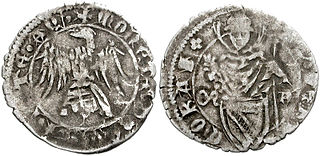
Marquard of Randeck was Patriarch of Aquileia from 1365 until his death.

<span class="mw-page-title-main">Slavia Friulana</span> Mountain region in northeastern Italy

Slavia Friulana, which means Friulian Slavia, is a small mountainous region in northeastern Italy and it is so called because of its Slavic population which settled here in the 8th century AD. The territory is located in the Italian region of Friuli-Venezia Giulia, between the town of Cividale del Friuli and the Slovenian border.

References

  1. Demographics and other statistics: Italian statistical institute Istat.
  2. http://www.comune.campolongotapogliano.ud.it/index.php?id=21791&L=0%27%22 History of Tapogliano
  3. Annali del Friuli Ossia raccolta delle cose storiche appartenenti a questa regione, Francesco Manzano (conte di.), 1858, Vol. IV, p. 211
  4. http://www.comune.campolongotapogliano.ud.it/index.php?id=21790&L=0%27%22 History of Campolongo
  5. 1 2 Biagio Rith de Colenberg, Commentaries on Modern War (1629)