Carn Brea is a civil parish and hilltop site in Cornwall, England, United Kingdom. The population of Carn Brea including Bosleake and Church Coombe was 8,013 at the 2011 census. The hilltop site is situated approximately one mile (1.6 km) southwest of Redruth. The settlements of Bosleake, Brea, Broad Lane, Carn Arthen, Carn Brea Village, Carnkie, Four Lanes, Grillis, Illogan Highway, Pencoys, Penhallick, Piece, Pool, Tolskithy, Tregajorran, Treskillard, Tuckingmill and West Tolgus are in the parish.

The Brisons is a twin-peaked islet in the Celtic Sea situated 1 mile (1.6 km) offshore from Cape Cornwall in Cornwall, on the south-western coast of Great Britain.
Camborne-Redruth was an urban district in Cornwall, England, from 1934 to 1974. It was formed as a merger of Camborne and Redruth urban districts along with parts of Redruth Rural District and Helston Rural District. The towns are about four miles apart and form a loose conurbation.

Illogan is a village and civil parish in west Cornwall, England, United Kingdom, two miles (3 km) northwest of Redruth. The population of Illogan was 5,404 at the 2011 census. In the same year the population of the Camborne-Redruth urban area, which also includes Carn Brea, Illogan and several satellite villages, stood at 55,400 making it the largest conurbation in Cornwall. Originally a rural area supporting itself by farming and agriculture, Illogan shared in the general leap into prosperity brought about by the mining boom, which was experienced by the whole Camborne-Redruth area.

Chapel Carn Brea is an elevated Hercynian granite outcrop, owned by the National Trust at the southern edge of the civil parish of St Just, Cornwall, England, United Kingdom. The hill is 5 kilometres (3.1 mi) south of St Just and 3.5 kilometres (2.2 mi) east of Sennen Cove, and just to the north of the A30 London to Land's End road, which runs through the village of Crows-an-Wra. It should not be confused with another Carn Brea, the hill overlooking the Camborne–Redruth area.
Bosleake is a mining hamlet southwest of Redruth in west Cornwall, England, UK. It is in the civil parish of Carn Brea.

Penweathers is a hamlet in west Cornwall, England, United Kingdom. It is approximately one mile (1.6 km) west of Truro city centre.

Four Lanes is a village in west Cornwall, England, United Kingdom approximately 3 miles (4.8 km) south of Redruth at grid reference SW 689 386 in the civil parish of Carn Brea.

Troon is a village in Cornwall, UK, 1+1⁄2 miles southeast of Camborne. The village lies at around 560 feet (170 m) above sea level. An electoral ward named Troon and Beacon covers the area north from Troon to the outskirts of Camborne. The population at the 2011 census was 5,410.

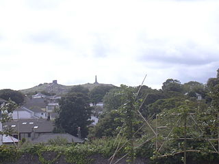
Brea is a village in Cornwall, England, UK, between the towns of Camborne and Redruth. It is in the civil parish of Carn Brea and consists of Brea, Lower Brea, and Higher Brea. A small stream, the Red River, flows through the village and a hill, Carn Brea dominates the landscape to the east, along with its monument to Francis Basset.

Carnkie is a village in west Cornwall, England, United Kingdom. It is situated approximately one and a half miles south west of Redruth. It is in the civil parish of Carn Brea.
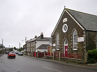
Broad Lane is a hamlet in the civil parish of Carn Brea near Illogan in Cornwall, England, UK. The current Methodist chapel of Broad Lane was built in 1887.
Grillis is a hamlet in the parish of Carn Brea, Cornwall, England.

Illogan Highway is a village on the A30 main road west of Redruth in Cornwall, England, United Kingdom. It is in the civil parish of Carn Brea.

Penhallick is a hamlet near Pool in Cornwall, England, UK. Penhallick House was built in 1892 by Richard Cowlin the local miller and grocer who owned Cowlin Mill. The mill was converted in the 1980s by Kerrier Groundwork and was offices for Cornwall Council. The mill building is currently for sale with potential change of use to residential.

Tregajorran is a hamlet in Cornwall, England. It is 2.5 miles (4.0 km) southwest of Redruth, in the civil parish of Carn Brea.
Carn Brea may refer to several places:
Kennack Sands is a beach and sand-dune system on the east coast of the Lizard Peninsula, Cornwall, England, UK.

Pool and Tehidy is an electoral division of Cornwall in the United Kingdom which returns one member to sit on Cornwall Council. The current councillor is Conservative Philip Desmonde.

Illogan was an electoral division of Cornwall in the United Kingdom which returned one member to sit on Cornwall Council between 2009 and 2021. It was abolished at the 2021 local elections, being succeeded by Illogan and Portreath.
