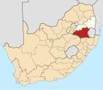
Carolina, South Africa

Last updated

Carolina
Erythrina zeyheri 50D 4589.jpg
A farm near Carolina
South Africa Mpumalanga location map.svg
Red pog.svg
Carolina
South Africa adm location map.svg
Red pog.svg
Carolina
Coordinates: 26°04′01″S30°07′01″E / 26.067°S 30.117°E / -26.067; 30.117
Country South Africa
Province Mpumalanga
District Gert Sibande
Municipality Albert Luthuli
Area
[1]
  Total14.66 km2 (5.66 sq mi)
Elevation
1,700 m (5,600 ft)
Population
 (2011) [1]
  Total16,846
  Density1,100/km2 (3,000/sq mi)
Racial makeup (2011)
[1]
   Black African 86.8%
   Coloured 0.6%
   Indian/Asian 2.0%
   White 10.4%
  Other0.1%
First languages (2011)
[1]
   Zulu 50.6%
   Swazi 25.8%
   Afrikaans 10.6%
   English 4.2%
  Other8.8%
Time zone UTC+2 (SAST)
Postal code (street)
1185
PO box
1185
Area code 017

Carolina is an urban-rural area situated at the intersection of the R33, R36 and R38 routes in the Mpumalanga province of South Africa. The town lies in the grass and wetlands region of Mpumalanga at 1700 meters above sea level. It is a mixed farming and small-scale coal- and precious-stone-mining community.

History

The Carolina Commando, established in 1895, with a flag. Carolina Commando, Transvaal, South Africa, with its flag.jpg
The Carolina Commando, established in 1895, with a flag.

Carolina was established by Cornelius Johannes Coetzee as a permanent outspan for wagons when gold was discovered in 1883 in Barberton. The town of Carolina was proclaimed on 15 June 1886 and named after his wife Magdalena Carolina Smit. The town was built on portions of the farms Groenvlei and Goedehoop and the first stands were sold in 1883. [2]

Carolina was rebuilt after it was razed in 1900 during the Second Boer War. A few examples of sandstone architecture are still to be found among Carolina's public buildings. The sandstone Grobler Bridge which crosses the Komati River on the present R36 route to Machadodorp was opened for traffic in 1897. It was named after Johannes Lodewikus Grobler. The cornerstone of the Dutch Reformed Church was laid by Commandant General Piet Joubert in October 1888. This building was severely damaged during the Second Boer War and used as a horse stable by British troops. The Ermelo Railway Company completed the Ermelo–Carolina–Machadodorp railway line in 1907. This placed Carolina on the trade route with Swaziland (now Eswatini). [2] The Komati River and associated Komati Gorge are situated in the vicinity of Carolina.

The very big township of Silobela, with its various sections, is situated nearby. Silobela is populated by mostly Swati-speaking people, though there are also Zulus, Ndebeles and a small number of Tsonga people.

Related Research Articles

<span class="mw-page-title-main">Witwatersrand Gold Rush</span> Gold rush in Johannesburg, South Africa

The Witwatersrand Gold Rush was a gold rush that began in 1886 and led to the establishment of Johannesburg, South Africa. It was a part of the Mineral Revolution.

The Netherlands–South African Railway Company or NZASM was a railway company established in 1887. The company was based in Amsterdam and Pretoria, and operated in the South African Republic (ZAR) during the late 19th century. At the request of ZAR president Paul Kruger, the NZASM constructed a railway line between Pretoria and Lourenço Marques in Portuguese East Africa.

<span class="mw-page-title-main">Belfast, Mpumalanga</span> Place in Mpumalanga, South Africa

Belfast is a small town in Mpumalanga Province, South Africa. It is situated in the eMakhazeni Local Municipality in the Nkangala District Municipality.

<span class="mw-page-title-main">Dullstroom</span> Place in Mpumalanga, South Africa

Dullstroom, also known as Emnothweni, is a small town in Mpumalanga province, South Africa. The town lies 35 kilometres north of Belfast and some 53 kilometres south-west of Lydenburg on the R540 road.

<span class="mw-page-title-main">Machadodorp</span> Place in Mpumalanga, South Africa

Machadodorp, also known by its official name eNtokozweni, is a small town situated on the N4 national highway, near the edge of the escarpment in the Mpumalanga province of South Africa. The Elands River runs through the town. There is a natural radioactive spring here that is reputed to have powerful healing qualities.

<span class="mw-page-title-main">Breyten</span> Place in Mpumalanga, South Africa

Breyten is a small farming town in Mpumalanga, South Africa. It is situated at the foot of Klipstapel, the highest point on the watershed between the westward-flowing Vaal River system and the eastward-flowing Olifants and Komati River systems. The town is located 25 km (15 mi) west of Chrissiesmeer, 30 km (19 mi) north of Ermelo, 32 km (20 mi) southwest of Carolina, and 35 km (21 mi) southeast of Hendrina. The main spoken languages are Zulu, Swati and Afrikaans.

<span class="mw-page-title-main">Ermelo, South Africa</span> Place in Mpumalanga, South Africa

Ermelo is the educational, industrial and commercial town of the 7,750 km2 Gert Sibande District Municipality in Mpumalanga province, Republic of South Africa. It is both a mixed agriculture and mining region. It is located 210 km east of Johannesburg.

<span class="mw-page-title-main">Komatipoort</span> Town in Mpumalanga, South Africa

Komatipoort is a town situated at the confluence of the Crocodile and Komati Rivers in Mpumalanga province, South Africa. The town is 8 km from the Crocodile Bridge Gate into the Kruger Park, and just 5 km from the Mozambique border and 65 km from the Eswatini border.

<span class="mw-page-title-main">R33 (South Africa)</span> Road in South Africa

The R33 is a provincial route in South Africa that connects Pietermaritzburg with Lephalale via Greytown, Paulpietersburg, Carolina, Belfast and Vaalwater. It is a very long road, passing through 3 provinces.

<span class="mw-page-title-main">R36 (South Africa)</span>

The R36 is a provincial route in South Africa that connects the N1 at Bandelierkop with Ermelo, via Tzaneen and Lydenburg. It is co-signed with the N4 for 8 kilometres between Machadodorp and Patattanek, with a tollgate on this section. It used to extend further south past Ermelo to Amersfoort, but that section is now designated as part of the N11.

<span class="mw-page-title-main">R37 (South Africa)</span>

The R37 is a provincial route in South Africa that connects Polokwane with Mbombela via Burgersfort and Lydenburg (Mashishing).

<span class="mw-page-title-main">R38 (South Africa)</span>

The R38 is a provincial route in South Africa that connects Standerton with Kaapmuiden via Bethal, Carolina and Barberton. It is a main route through the province of Mpumalanga.

<span class="mw-page-title-main">Komati River</span> River in Eswatini, Mozambique

The Komati River, also known as the Inkomati River or Incomati River, is a river in South Africa, Eswatini and Mozambique. Originating in north-western Eswatini, it is joined by the Crocodile River in the Lebombo Mountains, enters far south-western Mozambique below the border town of Komatipoort, and enters the Indian Ocean around 24 km (15 mi) north-east of Maputo.

<span class="mw-page-title-main">Battle of Leliefontein</span> 1900 battle of the Second Boer War

The Battle of Leliefontein was an engagement between British-Canadian and Boer forces during the Second Boer War on 7 November 1900, at the Komati River 30 kilometres (19 mi) south of Belfast at the present day Nooitgedacht Dam.

<span class="mw-page-title-main">Battle of Bergendal</span> 1900 battle of the Second Boer War

The Battle of Berg-en-dal took place in South Africa during the Second Anglo-Boer War.

<span class="mw-page-title-main">Komati Gorge</span>

Komati Gorge is a river valley in the Mpumalanga Province in central South Africa, which features vertical sandstone cliffs that provide habitat for a wide diversity of wildlife. Komati Gorge is located near the communities of Carolina and Machadodorp. The Komati River flows through the gorge and provides riparian cover for many species of flora and fauna, including several endemic endangered species and big game animals. The geology of the vertical cliffs of the gorge offer a diverse set of colourful mineralized exposures.

<span class="mw-page-title-main">Schoemans Kloof</span>

Schoemans Kloof Pass, or simply Schoemanskloof, is situated in Mpumalanga province, on the R539 road between the junction with the R36 at Bambi and the junction with the N4 about 16 kilometres north of Ngodwana. This scenic region is the access route that connects Gauteng to the warm Lowveld and Kruger National Park. The N4 highway is the pulse of this area as it runs along the Crocodile River. The agriculture in the area is dominated by citrus farming. Eco Tourism and hospitality in the Schoemanskloof is popular with travellers en route to the Kruger National Park with the first Mountain Links Golf Course set on the picturesque mountain range.

<span class="mw-page-title-main">Elands River (Mpumalanga)</span> River in Mpumalanga, South Africa

Elands River is a river of the Komati River basin in Mpumalanga province, South Africa.

<span class="mw-page-title-main">Panorama Route</span> Road in South Africa

The Panorama Route is a scenic road in South Africa connecting several cultural and natural points of interest. The route, steeped in the history of South Africa, is in Mpumalanga province, centred around the Blyde River Canyon, the world's third largest canyon. It features numerous waterfalls, one of the largest afforested areas in South Africa, and several natural landmarks. The route starts at the foot of the Long Tom Pass just outside Lydenburg, following the natural descent from the Great Escarpment to the Lowveld, and ending at the border of the Mpumalanga and Limpopo provinces near the Echo Caves.

<span class="mw-page-title-main">Pretoria–Maputo railway</span> Railway line in southern Africa

Pretoria–Maputo railway, also called Delagoa Bay railway, Iron railway and Eastern railway, is a railway that connects the city of Maputo, Mozambique, to the city of Pretoria, in South Africa. It is 567 km long, in 1067 mm gauge. The Mozambican section, between Maputo and Ressano Garcia, is managed by the state-owned Mozambique Ports and Railways (CFM) company, and it is officially known in Mozambique as the Ressano Garcia Line; in turn, on the South African stretch, between the town of Komatipoort and city of Pretoria, the administration is done by the company Transnet Freight Rail.

References

  1. 1 2 3 4 "Main Place Carolina". Census 2011.
  2. 1 2 Bornman, H. (1986). Carolina 1886-1986. Pretoria: Sigma-Pers.