Carshalton (UK Parliament constituency)

Last updated

Carshalton
Former county constituency
for the House of Commons
19451983
Seatsone
Created from Mitcham
Replaced by Carshalton and Wallington

Carshalton was a constituency combining with areas to the south-west, then to the east instead, Carshalton which is a suburb on a long, north–south hillside south of London. The latter form saw it take up an eastern "half" (i.e. one of two divisions) of the London Borough of Sutton. It returned one Member of Parliament (MP) to the House of Commons of the Parliament of the United Kingdom.

Contents

It was created for the 1945 general election having been the south-west of "Mitcham" and on shedding Banstead in 1974 it gained what had been the south-east of the Mitcham seat, then was abolished for the 1983 general election, when it was replaced by Carshalton and Wallington, a nearly identical eastern set of 13 wards of its (post-1965) solely related local government area (London Borough).

Boundaries

1945 UK general election map.svg
First version of the seat (at centre). Result in 1945. A north-west indent was the equally inceptive Sutton and Cheam seat.
UK General Election, October 1974.svg
Later version of the seat (at centre). Result in Oct. 1974. The seat swapped its bulk (south-west) on the North Downs for north-eastern suburbs.

1945–1974: The Urban Districts of Banstead and Carshalton.

Note: abolished as entities from April 1965, falling into Surrey County Council and the London Borough of Sutton respectively

1974–1983: The London Borough of Sutton wards of Beddington North, Beddington South, Carshalton Central, Carshalton North East, Carshalton North West, Carshalton St Helier North, Carshalton St Helier South, Carshalton St Helier West, Carshalton South East, Carshalton South West, Wallington Central, Wallington North, and Wallington South.

Members of Parliament

ElectionMemberPartyNotes
1945 Antony Head Conservative In 1960 elevated to the Lords
1960 by-election Walter Elliot Conservative
Feb 1974 Robert Carr Conservative MP for "Mitcham" 195074. In 1976 elevated to the Lords.
1976 by-election Nigel Forman Conservative continued in successor seat until his 1997 defeat

1983: constituency abolished: see Carshalton and Wallington

Election results

Elections in the 1940s

General election 1945: Carshalton
PartyCandidateVotes%±%
Conservative Antony Head 20,181 45.34
Labour William F Hawkins19,16443.05
Liberal Wilfrid Barrow 5,16711.61
Majority1,0172.29
Turnout 44,51277.07
Conservative win (new seat)

Elections in the 1950s

General election 1950: Carshalton
PartyCandidateVotes%±%
Conservative Antony Head 29,493 52.52
Labour S Sharman21,53638.35
Liberal Dennis W Clarke5,1329.14
Majority7,95714.17
Turnout 56,16188.14
Conservative hold Swing
General election 1951: Carshalton
PartyCandidateVotes%±%
Conservative Antony Head 32,634 58.73
Labour Clifford H Davies22,92841.27
Majority9,70617.46
Turnout 55,56285.07
Conservative hold Swing
General election 1955: Carshalton
PartyCandidateVotes%±%
Conservative Antony Head 30,429 55.70
Labour Harvey R Cole18,92434.64
Liberal Jack Henry Gordon Browne5,2779.66
Majority11,50521.06
Turnout 54,63080.87
Conservative hold Swing
General election 1959: Carshalton
PartyCandidateVotes%±%
Conservative Antony Head 30,454 53.99
Labour John H Powell17,21030.51
Liberal Jack Henry Gordon Browne8,74415.50
Majority13,24423.48
Turnout 56,40882.48
Conservative hold Swing

Elections in the 1960s

1960 Carshalton by-election
PartyCandidateVotes%±%
Conservative Walter Elliot 19,175 51.66 −2.33
Liberal Jack Henry Gordon Browne10,25027.61+12.11
Labour Brian Thomas7,69620.73−9.78
Majority8,92524.04+0.56
Turnout 37,121
Conservative hold Swing
General election 1964: Carshalton
PartyCandidateVotes%±%
Conservative Walter Elliot 26,118 48.88
Labour Brian Thomas16,10530.14
Liberal Jack Henry Gordon Browne11,20720.98
Majority10,01318.74
Turnout 53,43080.18
Conservative hold Swing
General election 1966: Carshalton
PartyCandidateVotes%±%
Conservative Walter Elliot 24,615 47.02
Labour Philip John Bassett18,74635.81
Liberal Jack Henry Gordon Browne8,98817.17
Majority5,86911.21
Turnout 52,34979.35
Conservative hold Swing

Elections in the 1970s

General election 1970: Carshalton
PartyCandidateVotes%±%
Conservative Walter Elliot 27,342 53.98
Labour Gilbert Samuel Baker16,89633.36
Liberal Jack Henry Gordon Browne6,41112.66
Majority10,44620.62
Turnout 50,64971.17
Conservative hold Swing
General election February 1974: Carshalton
PartyCandidateVotes%±%
Conservative Robert Carr 24,440 44.53
Labour Peter James Walker18,75034.16
Liberal Hester Margaret Gatty Smallbone11,69521.31
Majority5,69010.37
Turnout 54,88582.85
Conservative hold Swing
General election October 1974: Carshalton
PartyCandidateVotes%±%
Conservative Robert Carr 22,538 45.39 +0.86
Labour Bernard Frances Atherton18,84037.95+3.79
Liberal Hester Margaret Gatty Smallbone8,27216.664.65
Majority3,6987.45−2.92
Turnout 49,65074.288.57
Conservative hold Swing
Carshalton by-election 1976 [1]
PartyCandidateVotes%±%
Conservative Nigel Forman 20,753 51.69 +6.29
Labour Colin Blau11,02127.45−10.46
Liberal John Hatherley6,02815.01−1.65
National Front Terry Denville-Faulkner [2] 1,8514.61New
Conservative Anti-Common MarketReginald Simmerson2510.63New
Logic PartyWilliam Dunmore1330.33New
Air, Road, Public Safety, White Resident Bill Boaks 1150.29New
Majority9,73224.24
Turnout 40,15260.53
Conservative hold Swing
General election 1979: Carshalton [3]
PartyCandidateVotes%±%
Conservative Nigel Forman 26,492 51.30 +5.91
Labour Michael Geikie Ormerod16,12131.22−6.73
Liberal John Hatherley8,11215.71−0.95
National Front Terry Denville-Faulkner9191.78N/A
Majority10,37120.08+12.63
Turnout 51,64476.79+2.51
Conservative hold Swing

See also

As to 1945-1965 period: list of parliamentary constituencies in Surrey

Related Research Articles

<span class="mw-page-title-main">Beddington</span> Suburb of London

Beddington is a suburban settlement in the London Borough of Sutton on the boundary with the London Borough of Croydon. Beddington is formed from a village of the same name which until early the 20th century still included land which became termed entirely as Wallington. The latter was in the 13th century shown on local maps as Hakebrug, and named after a bridge on the River Wandle. The locality has a landscaped wooded park at Beddington Park – also known as Carew Manor; and a nature reserve and sewage treatment works in the centre and to the north of its area respectively. The population of Beddington according to the 2011 census is 21,044.

<span class="mw-page-title-main">Carshalton</span> Suburb of London

Carshalton is a town, with a historic village centre, in south London, England, within the London Borough of Sutton. It is situated 9.5 miles (15.3 km) south-southwest of Charing Cross, in the valley of the River Wandle, one of the sources of which is Carshalton Ponds in the middle of the village. Prior to the creation of Greater London in 1965, Carshalton was in the administrative county of Surrey.

<span class="mw-page-title-main">Wallington, London</span> Human settlement in England

Wallington is a town in the London Borough of Sutton, South London, England, 9.7 miles (15.6 km) south-west of Charing Cross. Before the Municipal Borough of Beddington and Wallington merged into the London Borough of Sutton in Greater London in 1965, it was part of the county of Surrey. Wallington is a post town in the SM postcode area.

<span class="mw-page-title-main">London Borough of Sutton</span> Borough in London, England

The London Borough of Sutton is an Outer London borough in London, England. It covers an area of 43 km2 (17 sq mi) and is the 80th largest local authority in England by population. It borders the London Borough of Croydon to the east, the London Borough of Merton to the north and the Royal Borough of Kingston upon Thames to the north-west; it also borders the Surrey boroughs of Epsom and Ewell to the west and Reigate and Banstead to the south. The local authority is Sutton London Borough Council. Its principal town is Sutton.

<span class="mw-page-title-main">East Surrey (UK Parliament constituency)</span> Parliamentary constituency in the United Kingdom, 1918 onwards

East Surrey is a constituency represented in the House of Commons of the UK Parliament since 2019 by Claire Coutinho, a Conservative who formerly served as Secretary of State for Energy Security and Net Zero. The seat covers an affluent area in the English county of Surrey.

<span class="mw-page-title-main">Carshalton and Wallington (UK Parliament constituency)</span> Parliamentary constituency in the United Kingdom, 1983 onwards

Carshalton and Wallington is a constituency represented in the House of Commons of the Parliament of the United Kingdom since 2024 by Bobby Dean, a Liberal Democrat.

<span class="mw-page-title-main">Reigate (UK Parliament constituency)</span> Parliamentary constituency in the United Kingdom, 1885 onwards

Reigate is a constituency in Surrey represented in the House of Commons of the UK Parliament since 2024 by Rebecca Paul, of the Conservative Party.

<span class="mw-page-title-main">Parliamentary constituencies in London</span>

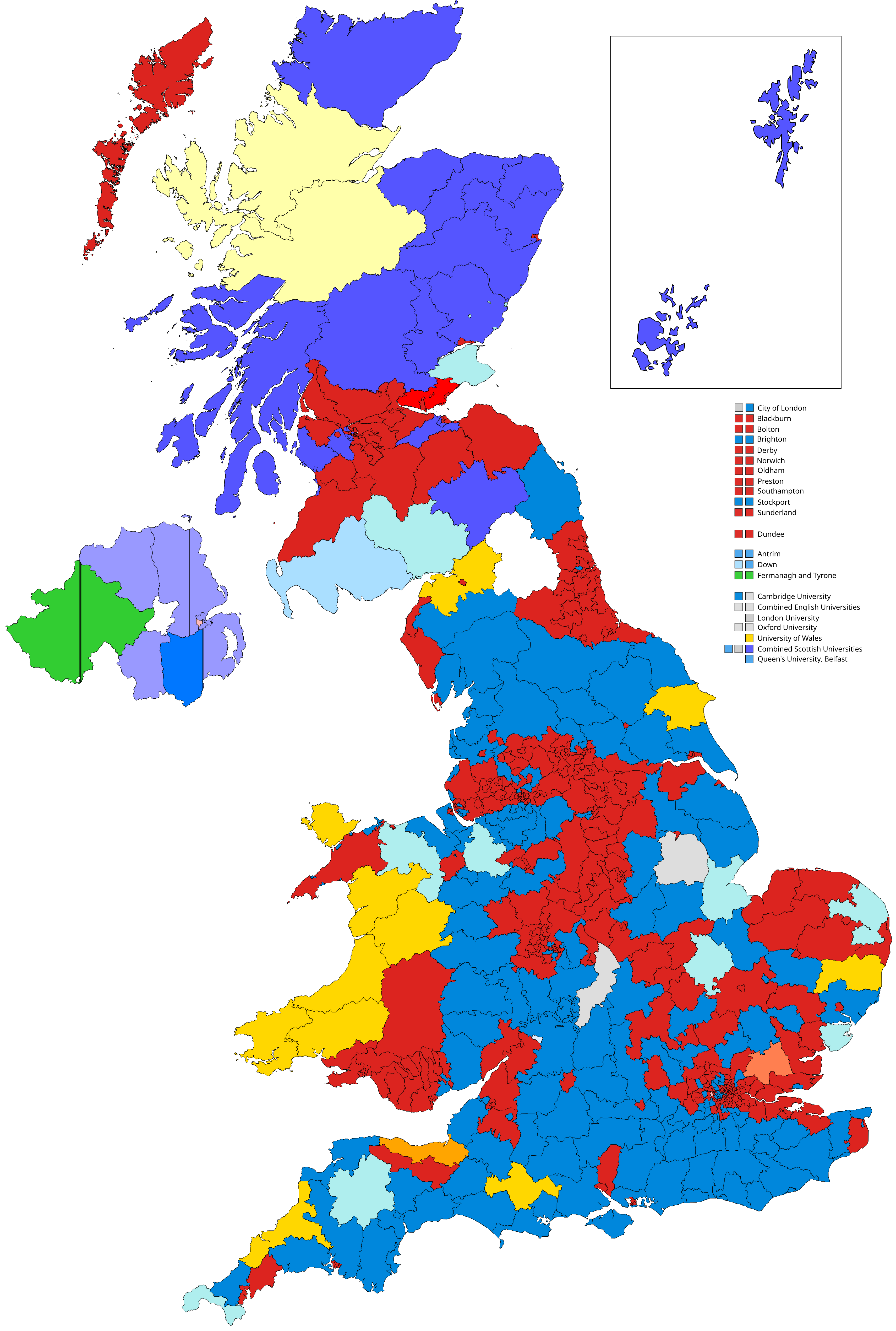
The region of Greater London, including the City of London, is divided into 75 parliamentary constituencies which are sub-classified as borough constituencies, affecting the type of electoral officer and level of expenses permitted.

<span class="mw-page-title-main">St Helier, London</span> Housing estate in London

St Helier is a residential cottage estate in the London boroughs of Merton and Sutton. The portion of the estate north of Green Lane and Bishopsford Road is in Merton, the remainder is in Sutton.

<span class="mw-page-title-main">London Government Act 1963</span> United Kingdom legislation

The London Government Act 1963 is an act of the Parliament of the United Kingdom, which created Greater London and a new local government structure within it. The Act significantly reduced the number of local government districts in the area, resulting in local authorities responsible for larger areas and populations. The upper tier of local government was reformed to cover the whole of the Greater London area and with a more strategic role; and the split of functions between upper and lower tiers was recast. The Act classified the boroughs into inner and outer London groups. The City of London and its corporation were essentially unreformed by the legislation. Subsequent amendments to the Act have significantly amended the upper tier arrangements, with the Greater London Council abolished in 1986, and the Greater London Authority introduced in 2000. As of 2024, the London boroughs are more or less identical to those created in 1965, although with some enhanced powers over services such as waste management and education.

<span class="mw-page-title-main">Municipal Borough of Sutton and Cheam</span>

Sutton and Cheam was a local government district in northeast Surrey, England from 1882 to 1965.

<span class="mw-page-title-main">Municipal Borough of Beddington and Wallington</span>

Beddington and Wallington was, from 1915 to 1965, a local government district in north east Surrey, England. It formed part of the London suburbs, lying within the Metropolitan Police District and the London Passenger Transport Area. In 1965 it was abolished on the creation of Greater London.

<span class="mw-page-title-main">Mitcham (UK Parliament constituency)</span> Parliamentary constituency in the United Kingdom, 1918–1974

Mitcham was a constituency comprising the emerging Mitcham, Wallington and Beddington suburbs of South London and until 1945 that of Carshalton, its largest of the area's four traditional divisions, in its south-west. It returned one Member of Parliament (MP) to the House of Commons of the Parliament of the United Kingdom by the first past the post system.

<span class="mw-page-title-main">Woodmansterne</span> Village in Surrey, England

Woodmansterne is a village in the borough of Reigate and Banstead, Surrey, bordering Greater London, England. It sits on a small plateau of and a southern down slope of the North Downs and its ecclesiastical parish borders continue to span old boundaries and reach into Chipstead, Coulsdon and Wallington.

<span class="mw-page-title-main">Wallington Hundred</span>

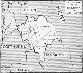
Wallington was an ancient hundred in the northeast of the historic county of Surrey, England. The majority of its area has been absorbed by the growth of London; with its name currently referring to the district of Wallington. Its former area now corresponds to the London Borough of Sutton, the majority of the London Borough of Croydon and parts of the London Borough of Merton as well as parts of the Districts of Epsom and Ewell, Reigate and Banstead and Tandridge in Surrey.

The Royal Commission on Local Government in Greater London, also known as the Herbert Commission, was established in 1957 and published its report in 1960. The report made recommendations for the overhaul of the administration of the capital. They were modified and implemented by the London Government Act 1963.

<span class="mw-page-title-main">Sutton Common</span>

Sutton Common is the name of former common land and a district and neighbourhood located in Sutton, London. The area is mostly located within the London Borough of Sutton, with some of the streets to the north and west of Sutton Common Park adjoining Lower Morden and Morden within the London Borough of Merton. Much of the area is taken up by the large Kimpton Park commercial and industrial estate, adjoining the A217. It is served by Sutton Common railway station. The area to the south and east of Oldfields Road uses an SM1 postcode and the area to the north and west uses SM3.

<span class="mw-page-title-main">2018 Sutton London Borough Council election</span>

The 2018 Sutton Council election took place on 3 May 2018 to elect members of Sutton Council in London. This was on the same day as other local elections.

The 2022 Sutton London Borough Council election took place on 5 May 2022. All 55 members of Sutton London Borough Council were elected. The elections took place alongside local elections in the other London boroughs and elections to local authorities across the United Kingdom.

References

  1. "1975 -76 by Elections". by-elections.co.uk. Archived from the original on 14 March 2012. Retrieved 12 January 2022.
  2. "NF". Archived from the original on 14 March 2012. Retrieved 27 September 2009.
  3. "Archived copy". Archived from the original on 3 March 2016. Retrieved 27 September 2009.{{cite web}}: CS1 maint: archived copy as title (link)