Castanea Township, Clinton County, Pennsylvania

Last updated
Castanea Township, Pennsylvania
Clinton County Pennsylvania incorporated and unincorporated areas Castanea township highlighted.svg
Location in Clinton County and the state of Pennsylvania.
Country United States
State Pennsylvania
County Clinton
Incorporated1877
Area
[1]
  Total5.86 sq mi (15.18 km2)
  Land5.51 sq mi (14.28 km2)
  Water0.35 sq mi (0.90 km2)
Population
 (2020) [2]
  Total1,095 Decrease2.svg
  Estimate 
(2021) [2]
1,093
  Density214.26/sq mi (82.73/km2)
FIPS code 42-035-11640

Castanea Township is a township in Clinton County, Pennsylvania, United States. The population was 1,095 at the 2020 census. [2]

Contents

Geography

According to the United States Census Bureau, the township has a total area of 5.9 square miles (15.2 km2), of which 5.5 square miles (14.3 km2) is land and 0.35 square miles (0.9 km2), or 5.94%, is water. [3] It is bordered to the north by the city of Lock Haven, the Clinton County seat.

Community

Demographics

Historical population
CensusPop.
1980 1,204
1990 1,188−1.3%
2000 1,2333.8%
2010 1,185−3.9%
2020 1,095−7.6%
2021 (est.)1,093 [2] −0.2%
source: [4] [5]

As of the census [6] of 2000, there were 1,233 people, 516 households, and 372 families residing in the township. The population density was 221.6 people per square mile (85.5/km2). There were 531 housing units at an average density of 95.4/sq mi (36.8/km2). The racial makeup of the township was 98.78% White, 0.08% African American, 0.65% Asian, 0.16% from other races, and 0.32% from two or more races. Hispanic or Latino of any race were 0.24% of the population.

There were 516 households, out of which 26.0% had children under the age of 18 living with them, 62.0% were married couples living together, 6.6% had a female householder with no husband present, and 27.9% were non-families. 21.3% of all households were made up of individuals, and 9.7% had someone living alone who was 65 years of age or older. The average household size was 2.39 and the average family size was 2.77.

In the township the population was spread out, with 20.0% under the age of 18, 7.9% from 18 to 24, 29.0% from 25 to 44, 25.8% from 45 to 64, and 17.3% who were 65 years of age or older. The median age was 41 years. For every 100 females, there were 93.6 males. For every 100 females age 18 and over, there were 91.3 males.

The median income for a household in the township was $33,657, and the median income for a family was $36,250. Males had a median income of $29,018 versus $20,721 for females. The per capita income for the township was $15,448. About 6.5% of families and 8.8% of the population were below the poverty line, including 7.5% of those under age 18 and 6.3% of those age 65 or over.

Related Research Articles

Tuscarora Township, Bradford County, Pennsylvania Township in Pennsylvania, United States

Tuscarora Township is a township in Bradford County, Pennsylvania, United States. The population was 1,131 at the 2010 census.

Burnside Township, Centre County, Pennsylvania Township in Pennsylvania, United States

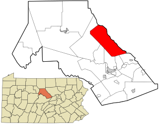
Burnside Township is a township in Centre County, Pennsylvania, United States. It is part of the State College, Pennsylvania Metropolitan Statistical Area. It is located approximately at 41°08′03″N77°09′58″W. The CDP of Pine Glen is within Burnside Township. The population was 439 at the 2010 census.

Marion Township, Centre County, Pennsylvania Township in Pennsylvania, United States

Marion Township is a township in Centre County, Pennsylvania, United States. It is part of the State College, Pennsylvania Metropolitan Statistical Area. The population was 1,224 at the 2010 census, up from 978 at the 2000 census. Part of Bald Eagle State Park is in Marion Township.

Bald Eagle Township, Clinton County, Pennsylvania Township in Pennsylvania, United States

Bald Eagle Township is a township in Clinton County, Pennsylvania, United States. The population was 2,039 at the 2020 census.

Beech Creek Township, Clinton County, Pennsylvania Township in Pennsylvania, United States

Beech Creek Township is a township in Clinton County, Pennsylvania, United States. The population was 966 at the 2020 census.

Castanea, Pennsylvania Census-designated place in Pennsylvania, United States

Castanea is a census-designated place (CDP) in Castanea Township, Clinton County, Pennsylvania, United States. The population was 1,125 at the 2010 census.

Chapman Township, Clinton County, Pennsylvania Township in Pennsylvania, United States

Chapman Township is a township in Clinton County, Pennsylvania, United States. The population was 886 at the 2020 census, down from 993 in 2000. It was originally settled in 1780 and became an official township on February 3, 1819. Originally part of Lycoming County, Chapman Township was incorporated into the newly formed Clinton County in 1839.

Colebrook Township, Clinton County, Pennsylvania Township in Pennsylvania, United States

Colebrook Township is a township in Clinton County, Pennsylvania, United States. The population was 196 at the 2020 census.

Crawford Township, Clinton County, Pennsylvania Township in Pennsylvania, United States

Crawford Township is a township in Clinton County, Pennsylvania, United States. The population was 968 at the 2020 census.

Dunnstable Township, Clinton County, Pennsylvania Township in Pennsylvania, United States

Dunnstable Township is a township in Clinton County, Pennsylvania, United States. The population was 1,002 at the 2020 census.

Dunnstown, Pennsylvania Census-designated place in Pennsylvania, United States

Dunnstown is a census-designated place (CDP) in Clinton County, Pennsylvania, United States. The population was 1,360 at the 2010 census.

Gallagher Township, Clinton County, Pennsylvania Township in Pennsylvania, United States

Gallagher Township is a township in Clinton County, Pennsylvania, United States. The population was 386 at the 2020 census.

Grugan Township, Clinton County, Pennsylvania Township in Pennsylvania, United States

Grugan Township is a township in Clinton County, Pennsylvania, United States. The population was 48 at the 2020 census.

Lamar Township, Clinton County, Pennsylvania Township in Pennsylvania, United States

Lamar Township is a township in Clinton County, Pennsylvania, United States. The population was 2,600 at the 2020 census.

Leidy Township, Clinton County, Pennsylvania Township in Pennsylvania, United States

Leidy Township is a township in Clinton County, Pennsylvania, United States. The population was 155 at the 2020 census, down from 180 in 2010. Kettle Creek State Park is located in Leidy Township.

Noyes Township, Clinton County, Pennsylvania Township in Pennsylvania, United States

Noyes Township is a township in Clinton County, Pennsylvania, United States. The population was 333 at the 2020 census, down from 357 in 2010.

Pine Creek Township, Clinton County, Pennsylvania Township in Pennsylvania, United States

Pine Creek Township is a township in Clinton County, Pennsylvania, United States. The population was 3,394 at the 2020 census. The township is named for Pine Creek, which flows into the West Branch Susquehanna River at the border of the township with Lycoming County, between the boroughs of Avis and Jersey Shore

Porter Township, Clinton County, Pennsylvania Township in Pennsylvania, United States

Porter Township is a township in Clinton County, Pennsylvania, United States. The population was 1,481 at the 2020 census.

Wayne Township, Clinton County, Pennsylvania Township in Pennsylvania, United States

Wayne Township is a township in Clinton County, Pennsylvania, United States. As of the 2020 census, the township had a population of 1,476, down from 1,666 in 2010.

Woodward Township, Clinton County, Pennsylvania Township in Pennsylvania, United States

Woodward Township is a township in Clinton County, Pennsylvania, United States. The population was 2,372 at the 2010 census.

References

  1. "2016 U.S. Gazetteer Files". United States Census Bureau. Retrieved Aug 13, 2017.
  2. 1 2 3 4 Bureau, US Census. "City and Town Population Totals: 2020—2021". Census.gov. US Census Bureau. Retrieved August 7, 2022.
  3. "Geographic Identifiers: 2010 Census Summary File 1 (G001): Castanea township, Clinton County, Pennsylvania". U.S. Census Bureau, American Factfinder. Archived from the original on February 13, 2020. Retrieved May 15, 2015.
  4. "Clinton County Comprehensive Plan" (PDF). Clinton County, Pennsylvania. Archived from the original (PDF) on 2007-11-29. Retrieved 2007-09-19.
  5. "Population Change 1990–2000: Pennsylvania". Pennsylvania State Data Center. Archived from the original on 2007-11-17. Retrieved 2007-09-19.
  6. "U.S. Census website". United States Census Bureau . Retrieved 2008-01-31.

Coordinates: 41°07′27″N77°25′53″W / 41.12417°N 77.43139°W / 41.12417; -77.43139