Gallagher Township, Clinton County, Pennsylvania

Last updated
Gallagher Township,
Pennsylvania
Township
Clinton County Pennsylvania incorporated and unincorporated areas Gallagher township highlighted.svg
Location in Clinton County and the state of Pennsylvania.
Country United States
State Pennsylvania
County Clinton
Settled1835
Incorporated1849
Area
[1]
  Total53.74 sq mi (139.17 km2)
  Land53.72 sq mi (139.12 km2)
  Water0.02 sq mi (0.05 km2)
Population
 (2020) [2]
  Total386 Increase2.svg
  Estimate 
(2021) [2]
387
  Density7.19/sq mi (2.77/km2)
FIPS code 42-035-28296

Gallagher Township is a township in Clinton County, Pennsylvania, United States. The population was 386 at the 2020 census. [2]

Contents

Geography

The township is in eastern Clinton County and is bordered to the northeast by Lycoming County. The northern third of the township-county boundary is formed by Pennsylvania Route 44, while the middle third of the boundary follows Pennsylvania Route 664. The highways intersect at the unincorporated community of Haneyville, which straddles the county line.

According to the United States Census Bureau, the township has a total area of 53.7 square miles (139.2 km2), of which 0.019 square miles (0.05 km2), or 0.04%, is water. [3] > Sproul State Forest occupies portions of the western side of the township.

Demographics

Historical population
CensusPop.
1980 194
1990 2139.8%
2000 34059.6%
2010 38112.1%
2020 3861.3%
2021 (est.)387 [2] 0.3%
source: [4] [5]

As of the census [6] of 2000, there were 340 people, 134 households, and 110 families residing in the township. The population density was 6.3 people per square mile (2.5/km2). There were 328 housing units at an average density of 6.1/sq mi (2.4/km2). The racial makeup of the township was 99.71% White, and 0.29% from two or more races. Hispanic or Latino of any race were 0.29% of the population.

There were 134 households, out of which 26.1% had children under the age of 18 living with them, 71.6% were married couples living together, 2.2% had a female householder with no husband present, and 17.9% were non-families. 14.2% of all households were made up of individuals, and 3.0% had someone living alone who was 65 years of age or older. The average household size was 2.54 and the average family size was 2.75.

In the township the population was spread out, with 20.3% under the age of 18, 4.7% from 18 to 24, 31.2% from 25 to 44, 32.6% from 45 to 64, and 11.2% who were 65 years of age or older. The median age was 42 years. For every 100 females, there were 109.9 males. For every 100 females age 18 and over, there were 122.1 males.

The median income for a household in the township was $39,531, and the median income for a family was $45,000. Males had a median income of $35,833 versus $16,250 for females. The per capita income for the township was $18,638. About 4.1% of families and 6.9% of the population were below the poverty line, including 4.3% of those under age 18 and 9.7% of those age 65 or over.

Related Research Articles

Hamiltonban Township, Adams County, Pennsylvania Township in Pennsylvania, United States

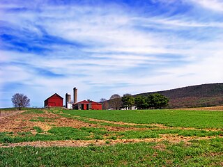
Hamiltonban Township is a township in Adams County, Pennsylvania, United States. The population was 2,372 at the 2010 census.

Standing Stone Township, Bradford County, Pennsylvania Township in Pennsylvania, United States

Standing Stone Township is a township in Bradford County, Pennsylvania, United States. The population was 642 at the 2010 census.

Goshen Township, Clearfield County, Pennsylvania Township in Pennsylvania, United States

Goshen Township is a township in Clearfield County, Pennsylvania, United States. The population was 395 at the 2020 census.

Allison Township, Clinton County, Pennsylvania Township in Pennsylvania, United States

Allison Township is a township in Clinton County, Pennsylvania, United States. The population was 228 at the 2020 census.

Castanea Township, Clinton County, Pennsylvania Township in Pennsylvania, United States

Castanea Township is a township in Clinton County, Pennsylvania, United States. The population was 1,095 at the 2020 census.

Chapman Township, Clinton County, Pennsylvania Township in Pennsylvania, United States

Chapman Township is a township in Clinton County, Pennsylvania, United States. The population was 886 at the 2020 census, down from 993 in 2000. It was originally settled in 1780 and became an official township on February 3, 1819. Originally part of Lycoming County, Chapman Township was incorporated into the newly formed Clinton County in 1839.

Crawford Township, Clinton County, Pennsylvania Township in Pennsylvania, United States

Crawford Township is a township in Clinton County, Pennsylvania, United States. The population was 968 at the 2020 census.

Greene Township, Clinton County, Pennsylvania Township in Pennsylvania, United States

Greene Township is a township in Clinton County, Pennsylvania, United States. The population was 1,750 at the 2020 census, up from 1,695 in 2010.

Leidy Township, Clinton County, Pennsylvania Township in Pennsylvania, United States

Leidy Township is a township in Clinton County, Pennsylvania, United States. The population was 155 at the 2020 census, down from 180 in 2010. Kettle Creek State Park is located in Leidy Township.

Noyes Township, Clinton County, Pennsylvania Township in Pennsylvania, United States

Noyes Township is a township in Clinton County, Pennsylvania, United States. The population was 333 at the 2020 census, down from 357 in 2010.

Porter Township, Clinton County, Pennsylvania Township in Pennsylvania, United States

Porter Township is a township in Clinton County, Pennsylvania, United States. The population was 1,481 at the 2020 census.

Lower Frankford Township, Cumberland County, Pennsylvania Township in Pennsylvania, United States

Lower Frankford Township is a township in Cumberland County, Pennsylvania, United States. The population was 1,732 at the 2010 census.

Lower Mifflin Township, Cumberland County, Pennsylvania Township in Pennsylvania, United States

Lower Mifflin Township is a township in Cumberland County, Pennsylvania, United States. The population was 1,783 at the 2010 census.

Upper Frankford Township, Cumberland County, Pennsylvania Township in Pennsylvania, United States

Upper Frankford Township is a township in Cumberland County, Pennsylvania, United States. The population was 2,005 at the 2010 census.

Jackson Township, Greene County, Pennsylvania Township in Pennsylvania, United States

Jackson Township is a township in Greene County, Pennsylvania, United States. The population was 379 at the 2020 census.

Cromwell Township, Huntingdon County, Pennsylvania Township in Pennsylvania, United States

Cromwell Township is a township in Huntingdon County, Pennsylvania, United States. The population was 1,510 at the 2010 census.

Decatur Township, Mifflin County, Pennsylvania Township in Pennsylvania, United States

Decatur Township is a township in Mifflin County, Pennsylvania, United States. The population was 2,978 at the 2020 census. This township is named after war hero Stephen Decatur, Jr.

Toboyne Township, Perry County, Pennsylvania Township in Pennsylvania, United States

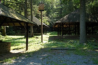
Toboyne Township is a township in Perry County, Pennsylvania, United States. The population was 467 at the 2020 census. Big Spring State Forest Picnic Area is on the western end of Toboyne Township near Conococheague Mountain. Fowlers Hollow State Park is also in the township. It is named after Taughboyne, County Donegal, Ireland.

Chatham Township, Tioga County, Pennsylvania Township in Pennsylvania, United States

Chatham Township is a township in Tioga County, Pennsylvania, United States. The population was 607 at the 2020 census.

Smith Township, Washington County, Pennsylvania Township in Pennsylvania, United States

Smith Township is a township in Washington County, Pennsylvania, United States. As of the 2020 census, the township population was 4,224.

References

  1. "2016 U.S. Gazetteer Files". United States Census Bureau. Retrieved Aug 13, 2017.
  2. 1 2 3 4 Bureau, US Census. "City and Town Population Totals: 2020—2021". Census.gov. US Census Bureau. Retrieved August 7, 2022.
  3. "Geographic Identifiers: 2010 Census Summary File 1 (G001): Gallagher township, Clinton County, Pennsylvania". U.S. Census Bureau, American Factfinder. Archived from the original on February 13, 2020. Retrieved May 15, 2015.
  4. "Clinton County Comprehensive Plan" (PDF). Clinton County, Pennsylvania. Archived from the original (PDF) on 2007-11-29. Retrieved 2007-09-19.
  5. "Population Change 1990–2000: Pennsylvania". Pennsylvania State Data Center. Archived from the original on 2007-11-17. Retrieved 2007-09-19.
  6. "U.S. Census website". United States Census Bureau . Retrieved 2008-01-31.

Coordinates: 41°14′00″N77°21′59″W / 41.23333°N 77.36639°W / 41.23333; -77.36639