Dunnstable Township, Clinton County, Pennsylvania

Last updated
Dunnstable Township,
Pennsylvania
Township
Rich-McCormick Woolen Factory 1.jpg
Rich-McCormick Woolen Factory, a historic site in the township
Clinton County Pennsylvania incorporated and unincorporated areas Dunnstable township highlighted.svg
Location in Clinton County and the state of Pennsylvania.
Country United States
State Pennsylvania
County Clinton
Settled1785
IncorporatedBefore 1839
Area
[1]
  Total9.61 sq mi (24.89 km2)
  Land9.38 sq mi (24.28 km2)
  Water0.23 sq mi (0.61 km2)
Population
 (2020) [2]
  Total1,002 Decrease2.svg
  Estimate 
(2021) [2]
1,010
  Density108.27/sq mi (41.80/km2)
FIPS code 42-035-20408

Dunnstable Township is a township in Clinton County, Pennsylvania, United States. The population was 1,002 at the 2020 census.

Contents

History

The Rich-McCormick Woolen Factory was listed on the National Register of Historic Places in 1985. [3]

Geography

According to the United States Census Bureau, the township has a total area of 9.6 square miles (24.9 km2), of which 9.4 square miles (24.3 km2) is land and 0.23 square miles (0.6 km2), or 2.45%, is water. [4]


Demographics

Historical population
CensusPop.
1980 982
1990 846−13.8%
2000 94511.7%
2010 1,0086.7%
2020 1,002−0.6%
2021 (est.)1,010 [2] 0.8%
source: [5] [6]

As of the census [7] of 2000, there were 945 people, 366 households, and 285 families residing in the township. The population density was 101.3 people per square mile (39.1/km2). There were 381 housing units at an average density of 40.8/sq mi (15.8/km2). The racial makeup of the township was 98.5% White, 0.3% African American, 0.6% Asian, 0.1% from other races, and 0.4% from two or more races. Hispanic or Latino of any race were 0.4% of the population.

There were 366 households, out of which 27.3% had children under the age of 18 living with them, 68.6% were married couples living together, 6.0% had a female householder with no husband present, and 21.9% were non-families. 17.8% of all households were made up of individuals, and 9.3% had someone living alone who was 65 years of age or older. The average household size was 2.57 and the average family size was 2.88.

In the township the population was spread out, with 21.7% under the age of 18, 5.3% from 18 to 24, 27.4% from 25 to 44, 28.8% from 45 to 64, and 16.8% who were 65 years of age or older. The median age was 43 years. For every 100 females there were 99.4 males. For every 100 females age 18 and over, there were 98.9 males.

The median income for a household in the township was $47,981, and the median income for a family was $51,250. Males had a median income of $32,333 versus $20,469 for females. The per capita income for the township was $19,382. About 4.1% of families and 5.4% of the population were below the poverty line, including 4.5% of those under age 18 and 9.7% of those age 65 or over.

Related Research Articles

Burnside Township, Centre County, Pennsylvania Township in Pennsylvania, United States

Burnside Township is a township in Centre County, Pennsylvania, United States. It is part of the State College, Pennsylvania Metropolitan Statistical Area. It is located approximately at 41°08′03″N77°09′58″W. The CDP of Pine Glen is within Burnside Township. The population was 439 at the 2010 census.

Liberty Township, Centre County, Pennsylvania Township in Pennsylvania, United States

Liberty Township is a township in Centre County, Pennsylvania, United States. It is part of the State College, Pennsylvania Metropolitan Statistical Area. The population was 2,118 at the 2010 census, up from 1,830 at the 2000 census. Part of Bald Eagle State Park is in Liberty Township.

Walker Township, Centre County, Pennsylvania Township in Pennsylvania, United States

Walker Township is a township in Centre County, Pennsylvania, United States. It is part of the State College, Pennsylvania Metropolitan Statistical Area. The population was 4,433 at the 2010 census, up from 3,299 at the 2000 census.

Allison Township, Clinton County, Pennsylvania Township in Pennsylvania, United States

Allison Township is a township in Clinton County, Pennsylvania, United States. The population was 228 at the 2020 census.

Bald Eagle Township, Clinton County, Pennsylvania Township in Pennsylvania, United States

Bald Eagle Township is a township in Clinton County, Pennsylvania, United States. The population was 2,039 at the 2020 census.

Beech Creek Township, Clinton County, Pennsylvania Township in Pennsylvania, United States

Beech Creek Township is a township in Clinton County, Pennsylvania, United States. The population was 966 at the 2020 census.

Castanea Township, Clinton County, Pennsylvania Township in Pennsylvania, United States

Castanea Township is a township in Clinton County, Pennsylvania, United States. The population was 1,095 at the 2020 census.

Castanea, Pennsylvania Census-designated place in Pennsylvania, United States

Castanea is a census-designated place (CDP) in Castanea Township, Clinton County, Pennsylvania, United States. The population was 1,125 at the 2010 census.

Colebrook Township, Clinton County, Pennsylvania Township in Pennsylvania, United States

Colebrook Township is a township in Clinton County, Pennsylvania, United States. The population was 196 at the 2020 census.

Crawford Township, Clinton County, Pennsylvania Township in Pennsylvania, United States

Crawford Township is a township in Clinton County, Pennsylvania, United States. The population was 968 at the 2020 census.

Dunnstown, Pennsylvania Census-designated place in Pennsylvania, United States

Dunnstown is a census-designated place (CDP) in Clinton County, Pennsylvania, United States. The population was 1,360 at the 2010 census.

Gallagher Township, Clinton County, Pennsylvania Township in Pennsylvania, United States

Gallagher Township is a township in Clinton County, Pennsylvania, United States. The population was 386 at the 2020 census.

Greene Township, Clinton County, Pennsylvania Township in Pennsylvania, United States

Greene Township is a township in Clinton County, Pennsylvania, United States. The population was 1,750 at the 2020 census, up from 1,695 in 2010.

Grugan Township, Clinton County, Pennsylvania Township in Pennsylvania, United States

Grugan Township is a township in Clinton County, Pennsylvania, United States. The population was 48 at the 2020 census.

Lamar Township, Clinton County, Pennsylvania Township in Pennsylvania, United States

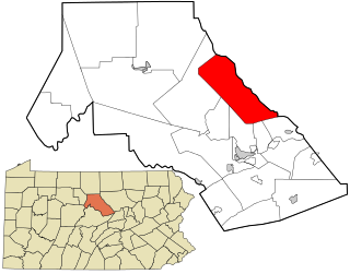
Lamar Township is a township in Clinton County, Pennsylvania, United States. The population was 2,600 at the 2020 census.

Leidy Township, Clinton County, Pennsylvania Township in Pennsylvania, United States

Leidy Township is a township in Clinton County, Pennsylvania, United States. The population was 155 at the 2020 census, down from 180 in 2010. Kettle Creek State Park is located in Leidy Township.

Logan Township, Clinton County, Pennsylvania Township in Pennsylvania, United States

Logan Township is a township in Clinton County, Pennsylvania, United States. The population was 872 at the 2020 census.

Pine Creek Township, Clinton County, Pennsylvania Township in Pennsylvania, United States

Pine Creek Township is a township in Clinton County, Pennsylvania, United States. The population was 3,394 at the 2020 census. The township is named for Pine Creek, which flows into the West Branch Susquehanna River at the border of the township with Lycoming County, between the boroughs of Avis and Jersey Shore

Wayne Township, Clinton County, Pennsylvania Township in Pennsylvania, United States

Wayne Township is a township in Clinton County, Pennsylvania, United States. As of the 2020 census, the township had a population of 1,476, down from 1,666 in 2010.

Shirley Township, Huntingdon County, Pennsylvania Township in Pennsylvania, United States

Shirley Township is a township in Huntingdon County, Pennsylvania, United States. The population was 2,524 at the 2010 census.

References

  1. "2016 U.S. Gazetteer Files". United States Census Bureau. Retrieved Aug 13, 2017.
  2. 1 2 3 Bureau, US Census. "City and Town Population Totals: 2020—2021". Census.gov. US Census Bureau. Retrieved August 7, 2022.
  3. "National Register Information System". National Register of Historic Places . National Park Service. July 9, 2010.
  4. "Geographic Identifiers: 2010 Census Summary File 1 (G001): Dunnstable township, Clinton County, Pennsylvania". U.S. Census Bureau, American Factfinder. Archived from the original on February 13, 2020. Retrieved May 15, 2015.
  5. "Clinton County Comprehensive Plan" (PDF). Clinton County, Pennsylvania. Archived from the original (PDF) on 2007-11-29. Retrieved 2007-09-19.
  6. "Population Change 1990–2000: Pennsylvania". Pennsylvania State Data Center. Archived from the original on 2007-11-17. Retrieved 2007-09-19.
  7. "U.S. Census website". United States Census Bureau . Retrieved 2008-01-31.

Coordinates: 41°10′06″N77°22′23″W / 41.16833°N 77.37306°W / 41.16833; -77.37306