Montana is a landlocked state in the Northwestern United States. Montana has several nicknames, although none are official, including "Big Sky Country" and "The Treasure State", and slogans that include "Land of the Shining Mountains" and more recently "The Last Best Place".

The Absaroka Range is a sub-range of the Rocky Mountains in the United States. The range stretches about 150 mi (240 km) across the Montana-Wyoming border, and 75 miles at its widest, forming the eastern boundary of Yellowstone National Park along Paradise Valley (Montana), and the western side of the Bighorn Basin. The range borders the Beartooth Mountains to the north and the Wind River Range to the south. The northern edge of the range rests along I-90 and Livingston, Montana. The highest peak in the range is Francs Peak, located in Wyoming at 13,153 ft (4,009 m). There are 46 other peaks over 12,000 ft (3,700 m).

The Cayuse are a Native American tribe in what is now the state of Oregon in the United States. The Cayuse tribe shares a reservation and government in northeastern Oregon with the Umatilla and the Walla Walla tribes as part of the Confederated Tribes of the Umatilla Indian Reservation. The reservation is located near Pendleton, Oregon, at the base of the Blue Mountains.

The Inland Northwest or Inland Empire is a region of the Pacific Northwest centered on the Greater Spokane Area, that includes all of Eastern Washington and North Idaho. Western Montana is sometimes considered part of the Inland Northwest, but generally is not considered part of the Inland Empire. Under some definitions, the term Inland Empire also excludes Central Washington.
As of 2016 the U.S. Census Bureau estimated the region's population at 2,240,645, comparable to that of New Mexico. Its Canadian counterpart, north of the border, is the British Columbia Interior. Significant urban centers include the Spokane–Coeur d'Alene area and the Tri-Cities.
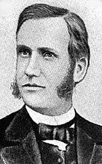
Marcus Whitman was an American physician.
In 1836, Marcus Whitman led an overland party by wagon to the West. Whitman and his wife Narcissa, along with Reverend Henry Spalding and his wife Eliza and William Gray, founded a mission at present day Walla Walla, Washington in an effort to convert local Indians to Christianity. In the winter of 1842 Whitman returned east, returning the following summer with the first large wagon train across the Oregon Trail. The new settlers encroached on the Cayuse Indians living near the Whitman Mission and were unsuccessful in their efforts to Christianize the Tribe. Following the deaths of a large number of nearby Cayuse from an outbreak of measles, some remaining Cayuse accused Marcus Whitman of murder, suggesting that he had administered poison and was a failed shaman. In retaliation, a group of Cayuse killed the Whitmans and twelve other settlers on November 29, 1847, an event that came to be known as the Whitman Massacre. Continuing warfare between settlers and Indians reduced the Cayuse numbers further.
The Cayuse War was an armed conflict that took place in the Northwestern United States from 1847 to 1855 between the Cayuse people of the region and the United States Government and local American settlers. Caused in part by the influx of disease and settlers to the region, the immediate start of the conflict occurred in 1847 when the Whitman Massacre took place at the Whitman Mission near present day Walla Walla, Washington when fourteen people were killed in and around the mission. Over the next few years the Provisional Government of Oregon and later the United States Army battled the Indians east of the Cascades. This was the first of several wars between the Indians and American settlers in that region that would lead to the negotiations between the United States and Indians of the Columbia Plateau, creating a number of Indian reservations.

The Crazy Mountains, often called the Crazies, are a mountain range in the northern Rocky Mountains in the U.S. state of Montana.

Whitman Mission National Historic Site is a United States National Historic Site located just west of Walla Walla, Washington, at the site of the former Whitman Mission at Waiilatpu. On November 29, 1847, Dr. Marcus Whitman, his wife Narcissa Whitman, and 11 others were slain by Native Americans of the Cayuse. The site commemorates the Whitmans, their role in establishing the Oregon Trail, and the challenges encountered when two cultures meet.

Showdown is an alpine ski area located in the Little Belt Mountains in Central Montana, United States.

The Gallatin Range is a mountain range of the Rocky Mountains, located in the U.S. states of Montana and Wyoming. It includes more than 10 mountains over 10,000 feet (3,000 m). The highest peak in the range is Electric Peak at 10,969 feet (3,343 m).

The Flathead Range is a mountain range of the Northern Rocky Mountains located south-east of Whitefish, Montana in the Great Bear Wilderness, part of the Bob Marshall Wilderness Complex. It is east of the Swan Range and southeast of the Whitefish Range. Its west side is drained by the South Fork Flathead River which forms Hungry Horse Reservoir.
The Horseshoe Hills, el. 6,673 feet (2,034 m), are a roughly crescent-shaped range of hills north of Manhattan, Montana in Gallatin County, Montana. They lie in the area between the southern Big Belt Mountains and the northern Bridger Range. The hills are bounded on the north by Sixteen Mile Creek, the first major tributary of the Missouri River. As they are in the rain shadow of the Boulder, Elkhorn, and Bull Mountains to the west, the Horseshoe Hills are notably dry, receiving 10 - 12 inches of precipitation annually. This is especially true on the southern and southeastern flanks, which are also in the rain shadow of the hills themselves. In the driest areas, Missouri foxtail cacti, plains prickly pear cacti, and yucca abound, as well as prairie rattlesnakes. Much of the hills are private property, but there is also some State, BLM, and National Forest land.
The Little Snowy Mountains are a small mountain range in central Montana about 25 miles (40 km) southeast of Lewistown. The range lies mostly in Fergus County, but the southern part of the range extends into Golden Valley and Musselshell counties.
In Montana, the South Hills are the small foothills in various Montana communities, most notably those at el. 3,592 feet (1,095 m), south of Missoula, Montana in Missoula County, Montana. Several districts of Missoula, Montana are, also, in the South Hills.