Cervières, Hautes-Alpes

Last updated • a couple of secsFrom Wikipedia, The Free Encyclopedia

Cervières
Cervieres -501.jpg
A view of the church of Saint-Michel-et-Saint-Mammès and the church of Saint-Michel
Blasonville fr Cervieres 05.svg
Location of Cervières
Cervieres, Hautes-Alpes
France location map-Regions and departements-2016.svg
Red pog.svg
Cervières
Provence-Alpes-Cotes d'Azur region location map.svg
Red pog.svg
Cervières
Coordinates: 44°52′14″N6°43′21″E / 44.8706°N 6.7225°E / 44.8706; 6.7225
Country France
Region Provence-Alpes-Côte d'Azur
Department Hautes-Alpes
Arrondissement Briançon
Canton Briançon-1
Intercommunality Briançonnais
Government
  Mayor (20202026) Jean-Franck Vioujas [1]
Area
1
109.68 km2 (42.35 sq mi)
Population
 (Jan. 2020) [2]
195
  Density1.8/km2 (4.6/sq mi)
Time zone UTC+01:00 (CET)
  Summer (DST) UTC+02:00 (CEST)
INSEE/Postal code
05027 /05100
Elevation1,375–3,294 m (4,511–10,807 ft)
(avg. 1,620 m or 5,310 ft)
1 French Land Register data, which excludes lakes, ponds, glaciers > 1 km2 (0.386 sq mi or 247 acres) and river estuaries.

Cervières is a commune in the Hautes-Alpes department in southeastern France.

Contents

The village lies at the foot of the Col d'Izoard, which is often on the route of the Tour de France and Giro d'Italia.

Population

Historical population
YearPop.±% p.a.
1968 111    
1975 96−2.05%
1982 105+1.29%
1990 120+1.68%
1999 129+0.81%
2009 169+2.74%
2014 183+1.60%
2020 195+1.06%
Source: INSEE [3]

See also

Related Research Articles

<span class="mw-page-title-main">Hautes-Alpes</span> Department in Provence-Alpes-Côte dAzur, France

Hautes-Alpes is a department in the Provence-Alpes-Côte d'Azur region of Southeastern France. It is located in the heart of the French Alps, after which it is named. Hautes-Alpes had a population of 141,220 as of 2019, which makes it the third least populated French department. Its prefecture is Gap; its sole subprefecture is Briançon. Its INSEE and postal code is 05.

<span class="mw-page-title-main">Arrondissement of Briançon</span> Arrondissement in Provence-Alpes-Côte dAzur, France

The arrondissement of Briançon is an arrondissement of France in the Hautes-Alpes department in the Provence-Alpes-Côte d'Azur region. It has 36 communes. Its population is 35,266 (2016), and its area is 2,138.1 km2 (825.5 sq mi).

<span class="mw-page-title-main">Beynes, Alpes-de-Haute-Provence</span> Commune in Provence-Alpes-Côte dAzur, France

Beynes is a commune in the Alpes-de-Haute-Provence department in southeastern France.

<span class="mw-page-title-main">Brunet, Alpes-de-Haute-Provence</span> Commune in Provence-Alpes-Côte dAzur, France

Brunet is a commune in the Alpes-de-Haute-Provence department in southeastern France.

<span class="mw-page-title-main">Claret, Alpes-de-Haute-Provence</span> Commune in Provence-Alpes-Côte dAzur, France

Claret is a commune in the Alpes-de-Haute-Provence department in southeastern France.

<span class="mw-page-title-main">Gréoux-les-Bains</span> Commune in Provence-Alpes-Côte dAzur, France

Gréoux-les-Bains is a commune in the Alpes-de-Haute-Provence department in the Provence-Alpes-Côte d'Azur region in Southeastern France. Best known for its Château des Templiers, the town is on the right bank of the river Verdon. The commune, on the departmental border with Var, had a population of 2,639 in 2019.

<span class="mw-page-title-main">L'Hospitalet, Alpes-de-Haute-Provence</span> Place in Provence-Alpes-Côte dAzur, France

L'Hospitalet is a commune in the Alpes-de-Haute-Provence department in southeastern France.

<span class="mw-page-title-main">Les Mées, Alpes-de-Haute-Provence</span> Commune in Provence-Alpes-Côte dAzur, France

Les Mées is a commune in the Alpes-de-Haute-Provence department in southeastern France.

<span class="mw-page-title-main">Montclar, Alpes-de-Haute-Provence</span> Commune in Provence-Alpes-Côte dAzur, France

Montclar is a commune in the Alpes-de-Haute-Provence department in southeastern France.

<span class="mw-page-title-main">Sigoyer, Alpes-de-Haute-Provence</span> Commune in Provence-Alpes-Côte dAzur, France

Sigoyer is a commune in the Alpes-de-Haute-Provence department in southeastern France.

<span class="mw-page-title-main">Thèze, Alpes-de-Haute-Provence</span> Commune in Provence-Alpes-Côte dAzur, France

Thèze is a commune in the Alpes-de-Haute-Provence department in southeastern France.

<span class="mw-page-title-main">Le Castellet, Alpes-de-Haute-Provence</span> Commune in Provence-Alpes-Côte dAzur, France

Le Castellet is a commune in the Alpes-de-Haute-Provence department in southeastern France.

<span class="mw-page-title-main">Montfort, Alpes-de-Haute-Provence</span> Commune in Provence-Alpes-Côte dAzur, France

Montfort is a commune in the Alpes-de-Haute-Provence department in southeastern France.

<span class="mw-page-title-main">Saumane, Alpes-de-Haute-Provence</span> Commune in Provence-Alpes-Côte dAzur, France

Saumane is a commune in the Alpes-de-Haute-Provence department in southeastern France.

<span class="mw-page-title-main">Le Vernet, Alpes-de-Haute-Provence</span> Commune in Provence-Alpes-Côte dAzur, France

Le Vernet is a commune in the Alpes-de-Haute-Provence department, and in the region of Provence-Alpes-Côte d'Azur, in southeastern France.

Rochebrune may refer to the following places in France:

<span class="mw-page-title-main">Rochebrune, Hautes-Alpes</span> Commune in Provence-Alpes-Côte dAzur, France

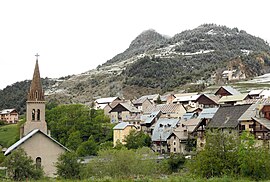
Rochebrune is a commune in the Hautes-Alpes department in southeastern France.

<span class="mw-page-title-main">Aiguilles</span> Commune in Provence-Alpes-Côte dAzur, France

Aiguilles is a commune of the Hautes-Alpes department in southeastern France.

<span class="mw-page-title-main">Canton of Chorges</span> Canton in Provence-Alpes-Côte dAzur, France

The canton of Chorges is an administrative division in southeastern France. At the French canton reorganisation which came into effect in March 2015, the canton was expanded from 8 to 17 communes:

<span class="mw-page-title-main">Lac des Cordes</span>

Lac des Cordes is a lake in Hautes-Alpes, France. At an elevation of 2,446 metres (8,025 ft), its surface area is 0.02 square kilometres (0.0077 sq mi). It is located close to the northern wall of the Pic de Rochebrune.

References

  1. "Répertoire national des élus: les maires". data.gouv.fr, Plateforme ouverte des données publiques françaises (in French). 2 December 2020.
  2. "Populations légales 2020". The National Institute of Statistics and Economic Studies. 29 December 2022.
  3. Population en historique depuis 1968, INSEE