
Alberta is one of the thirteen provinces and territories of Canada. Located in Western Canada, the province has an area of 661,190 km2 (255,290 sq mi) and is bounded to the south by the United States state of Montana along 49° north for 298 km (185 mi); to the east at 110° west by the province of Saskatchewan for 1,223 km (760 mi); and at 60° north the Northwest Territories for 644 km (400 mi). The southern half of the province borders British Columbia along the Continental Divide of the Americas on the peaks of the Rocky Mountains, while the northern half borders British Columbia along the 120th meridian west. Along with Saskatchewan it is one of only two landlocked provinces or territories.
Hinton/Entrance Airport is located 6 nautical miles west of Hinton, Alberta, Canada, just north of the Athabasca River. There are hangars, fuel, and minimal rest facilities on site.
Athabasca Regional Airport is a registered aerodrome located 3.1 nautical miles east northeast of Athabasca, Alberta, Canada. It serves private and commercial aircraft.
Assiniboia Airport is located 6 nautical miles north of Assiniboia, Saskatchewan, Canada.
Big River Airport is located near to Big River, Saskatchewan, Canada.
Cigar Lake Airport is located 1 nautical mile south-west of Waterbury Lake, Saskatchewan, Canada in the Athabasca Basin. It serves the Cigar Lake Mine.
Estevan Regional Aerodrome is an aerodrome located 3 nautical miles north of Estevan, Saskatchewan, Canada.
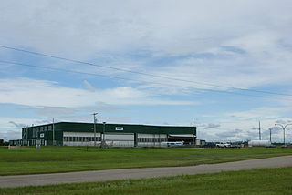
Key Lake Airport is a regional airport near the Key Lake mine in Saskatchewan, Canada.
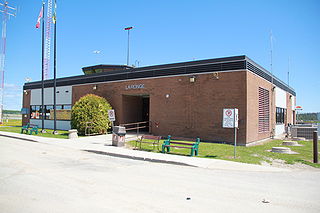
La Ronge Airport is located 2 nautical miles northeast of La Ronge, Saskatchewan, Canada.
Nipawin Airport is located 1.3 nautical miles south of Nipawin, Saskatchewan, Canada.

Stony Rapids Airport is located adjacent to Stony Rapids, Saskatchewan, Canada.
Uranium City Airport is located 4 nautical miles east of Uranium City, Saskatchewan, Canada. It is classified as a Code 2 airport.
Yorkton Municipal Airport is located 2.8 nautical miles north of Yorkton, Saskatchewan, Canada.
Squaw Rapids Airport, formerly TC LID: CKQ2, is located 2.5 nautical miles south-west of Thunder Rapids Lodge, Saskatchewan, Canada, in the RM of Moose Range No. 486. It is north-east of E.B. Campbell Hydroelectric Station and Tobin Lake by the Saskatchewan River.

Wollaston Lake is a lake in north-eastern part of the Canadian province of Saskatchewan. It is about 550 kilometres (340 mi) north-east of Prince Albert. With a surface area of 2,286 square kilometres (883 sq mi), it is the largest bifurcation lake in the world – that is, a lake that drains naturally in two directions.

The Rural Municipality of Arborfield No. 456 is a rural municipality (RM) in the Canadian province of Saskatchewan within Census Division No. 14 and SARM Division No. 4.
Highway 999 is a provincial highway in the far north region of the Canadian province of Saskatchewan. It is split in two sections and serves the small settlement of Camsell Portage and Charlot River Airport on the north side of Lake Athabasca. The western section of the highway is about 2 kilometres (1.2 mi) long and serves Camsell Portage, which is the northern-most settlement in Saskatchewan, and Camsell Portage Airport. The eastern section is about 12.3 kilometres (7.6 mi) long and runs from Charlot River Airport on the shore of Lake Athabasca east to Dam Lake. The highway provides access to the three Athabasca System Hydroelectric Stations.
Camsell Portage is a northern settlement of 5 people, located on the north-central shore of Lake Athabasca. The northern settlement is an unincorporated community in the Northern Saskatchewan Administration District.
Athabasca System Hydroelectric Stations are a series of small run-of-the-river hydroelectricity stations on the Charlot River in the Athabasca region owned by SaskPower, located near Uranium City, Saskatchewan, Canada. Access to the stations is from the Charlot River Airport and Highway 999.

