Related Research Articles

Thrissur, formerly Trichur, also known by its historical name Thrissivaperur, is a city and the headquarters of the Thrissur district in Kerala, India. It is the third largest urban agglomeration in Kerala after Kochi and Kozhikode, and the 21st largest in India. The city is built around a 65-acre (26 ha) hillock called the Thekkinkaadu Maidaanam which seats a large Hindu Shiva Temple. It is located central of the state, and 304 kilometres (189 mi) north-west of the state's capital city, Thiruvananthapuram. Thrissur was once the capital of the Kingdom of Cochin, and was a point of contact for the Assyrians, Greeks, Persians, Arabs, Romans, Portuguese, Dutch and English.

Ollukara is a residential area in the City of Thrissur in Kerala state of India. Ollukkara is the Ward 15 of Thrissur Municipal Corporation. It is located close to Mannuthy. It is the first village in Kerala to attain legal literacy.
Ramavarmapuram is the northern suburb of Thrissur City in Kerala. This suburban area is home to several governmental and other institutions of national importance. The largest menhir type megalithic monument in granite in Kerala is found here. A local catholic church has recently been adorned with mural paintings in the traditional Kerala style. This is the first instance of such a church decoration in Kerala in modern times.
The city of Thrissur, the cultural capital of Kerala, is also a major commercial and business hub of South India. It is said to be the heartland of Kerala's business acumen and home to most every leading Malayali entrepreneurs. The city which is famous for Bullion, Banking and its Business acumen, is the darling of investors in Kerala. Thrissur is also referred as the Golden city of India. It manufactures 70% of plain gold jewellery in Kerala per day. According to a survey, Thrissur city has been placed on 7th among the ten cities in India to reside. According to Registrar of Companies, the period from 1 January to 31 March 2010, 87 companies were registered in Thrissur and stood second in Kerala after Cochin. Thrissur's traditional strength lies in best entrepreneurial and financial capabilities.

Oushadhi or Pharmaceutical Corporation Kerala Ltd is an Ayurvedic medicine manufacturing company situated in Kuttanellur, in Thrissur City of Kerala state. It is a fully Government of Kerala owned company and produces around 450 ayurvedic formulations.

Marth Mariam Cathedral is the cathedral of the Chaldean Syrian Church of India, part of the Assyrian Church of the East. It is located in Thrissur City in the state of Kerala, It is the city's first Christian church inside the fort gates and is the fourth church in the Thrissur Municipal Corporation
Aswini Hospital is a private hospital situated in Thrissur, in the Kerala state of India. It is situated near Vadakkechira Bus stand and Poonkunam railway station in Thrissur Corporation. Established as a 40-bed hospital in 1987, it is now a 300-bed Multi-Super Speciality General Hospital. The hospital also runs the Aswini School of Nursing in Nadathara, Thrissur. The hospital offers treatment to the people of Thrissur, Palakkad and Malappuram districts.
International Film Festival of Thrissur (IFFT) is an annual event held in Thrissur in Kerala. It started in August 2004 as a joint venture by Thrissur Chalachitra Kendram, a film fraternity of Thrissur, Thrissur Corporation, Thrissur Jilla panchayath, Kerala State Film Development Corporation and the Federation of Film Societies of India. It is the second-largest film festival in Kerala. Masters and Classics, Children's films, Young films, Beyond Universe, Folk waves and Contemporary World Films are the major sessions in the festival.
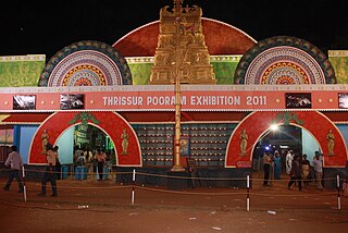
All India Agricultural, Industrial, Educational and Cultural Exhibition or commonly called the Thrissur Pooram Exhibition is an exhibition organised jointly by Paramekkavu Bagavathi Temple Devaswom and Thiruvambadi Sri Krishna Temple Devaswom, ahead of Thrissur Pooram in Thekkinkadu Maidan in Thrissur city. It is usually conducted over a period of 40 to 50 days during the Thrissur Pooram.The exhibition is the largest in Kerala in terms of attendance and floor space.
The Thrissur Municipal Corporation is the civic body that governs the Thrissur city in Kerala, India. It is the third largest city Corporation in the state of Kerala by area and fourth largest in population. Established as a Municipality since 1921 under the Cochin Municipal Regulations, it is responsible for civic infrastructure and administration; the distribution of electricity and water for Thrissur city. The Corporation manages 101.42 km of Thrissur city limits of through 55 wards through five zones Ayyanthole, Vilvattom, Ollukkara, Ollur and Koorkanchery. Thrissur Municipal Corporation has been formed with functions to improve the infrastructure of town.

Thrissur-Ponnani Kole Wetlands is a wetland lying in Thrissur and Malappuram districts in Kerala, India. It gives 40 per cent of the Kerala’s rice requirement and acts as a natural drainage system for Ponnani city, Thrissur city, Thrissur District, and Malappuram district. The Kole Wetlands is one of largest, highly productive and threatened wetlands in Kerala and it comes in Central Asian Flyway of migratory birds.
The city of Thrissur is situated in the southwest of the South Indian state of Kerala of Thrissur district. A landlocked city, Thrissur is located on a hillock which is surrounded by Thrissur Kole Wetlands. Thrissur district borders with Palakkad district in east, Malappuram district in the north, Ernakulam district in the South and Arabian Sea in the west.
Peringavu is a residential area situated in the City of Thrissur in Kerala state of India. Peringavu is Ward 5 of Thrissur Municipal Corporation.
Kalathodu is a residential area situated in the City of Thrissur in Kerala state of India. Kalathodu is Ward 20 of Thrissur Municipal Corporation.
Chettupuzha is a residential area situated in the City of Thrissur in Kerala state of India. Chettupuzha is Ward 44 of Thrissur Municipal Corporation.
Civil Station is a residential area situated in the City of Thrissur in Kerala state of India. Civil Station is Ward 54 of Thrissur Municipal Corporation.
Administration of Thrissur is handled by the Thrissur Municipal Corporation, consisting of 55 councilors and headed by the city's mayor.
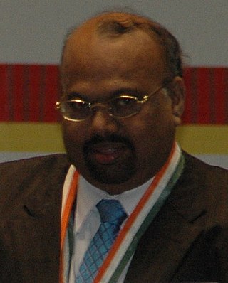
Cheril Krishna Menon was an Indian entrepreneur and philanthropist. He was the Chairman and Managing Director of Behzad Corporation, headquartered in Doha, Qatar, which has presence in many other countries. He received the 2006 Pravasi Bharatiya Samman and in 2009 received the fourth highest Indian civilian award, Padma Shri, from Government of India, in 2009, with. He died after prolonged illness at Apollo Hospital, Chennai on 1 October 2019, aged 70.

Thrissur District has four types of administrative hierarchies:
References
- ↑ "Municipal Council". Corporation of Thrissur. Archived from the original on 24 December 2012. Retrieved 1 July 2012.
- ↑ "All Information on Kerala". THRISSUR CORPORATION. Archived from the original on 18 August 2013. Retrieved 1 July 2012.