Chical, New Mexico | |
---|---|
Coordinates: 34°52′06″N106°40′06″W / 34.86833°N 106.66833°W Coordinates: 34°52′06″N106°40′06″W / 34.86833°N 106.66833°W | |
Country | United States |
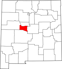
State | New Mexico |
County | Valencia |
Area | |
• Total | 0.81 sq mi (2.10 km2) |
• Land | 0.81 sq mi (2.10 km2) |
• Water | 0.00 sq mi (0.00 km2) |
Elevation | 4,902 ft (1,494 m) |
Population | |
• Total | 124 |
• Density | 152.90/sq mi (59.05/km2) |
Time zone | UTC-7 (Mountain (MST)) |
• Summer (DST) | UTC-6 (MDT) |
Area code | 505 |
GNIS feature ID | 899582 [3] |
Chical is a census-designated place in Valencia County, New Mexico, United States. Its population was 107 as of the 2010 census. [4]
Chical is located at 34°52′06″N106°40′06″W / 34.8683864°N 106.6683583°W . [3] According to the U.S. Census Bureau, the community has an area of 0.826 square miles (2.14 km2), all land. [4]
Historical population | |||
---|---|---|---|
Census | Pop. | %± | |
2020 | 124 | — | |
U.S. Decennial Census [5] [2] |
It is in the Los Lunas Public Schools school district. [6]
Valencia County is a county in the U.S. state of New Mexico. As of the 2010 census, the population was 76,569. The county seat is Los Lunas.
Bosque Farms is a village in Valencia County, New Mexico, United States. The population was 3,904 at the 2010 census. It is part of the Albuquerque Metropolitan Statistical Area.
El Cerro Mission is a census-designated place (CDP) in Valencia County, New Mexico, United States. The population was 4,657 at the 2010 census. It is part of the Albuquerque Metropolitan Statistical Area.
Jarales is a census-designated place (CDP) in Valencia County, New Mexico, United States. The population was 2,475 at the 2010 census. It is part of the Albuquerque Metropolitan Statistical Area.
Los Chavez is a census-designated place (CDP) in Valencia County, New Mexico. The population was 5,033 at the time of the 2000 census. It is part of the Albuquerque Metropolitan Statistical Area.
Los Lunas is a village in Valencia County, New Mexico, United States. As of the 2010 census, the village population is 14,835 inside the village limits due to the new housing developments at El Cerro de Los Lunas. It is the county seat of Valencia County. Los Lunas is part of the Albuquerque Metropolitan Statistical Area. The name "Los Lunas" is a partial Anglicization of the name of the Luna family, who originally settled in the area.
Rio Communities is a city in Valencia County, New Mexico, United States. Prior to its incorporation on May 16, 2013, it was a census-designated place (CDP). The CDP population was 4,723 as of the 2010 census.
Valencia is a census-designated place (CDP) in Valencia County, New Mexico, United States. The population was 2,192 at the 2010 census. It is part of the Albuquerque Metropolitan Statistical Area.
Lemitar is a census-designated place in Socorro County, New Mexico, United States. Its population was 330 as of the 2010 census. Lemitar has a post office with ZIP code 87823. Exit 156 on Interstate 25 serves the community.
Las Maravillas is a census-designated place in Valencia County, New Mexico, United States. Its population was 1,628 as of the 2010 census.
Sausal is a census-designated place in Valencia County, New Mexico, United States. Its population was 1,258 as of the 2010 census.
Highland Meadows is a census-designated place in Valencia County, New Mexico, United States. Its population was 624 as of the 2010 census.
Madrone is a census-designated place in Valencia County, New Mexico, United States. Its population was 707 as of the 2010 census. New Mexico State Road 304 passes through the community.
Pueblitos is a census-designated place in Valencia County, New Mexico, United States. Its population was 794 as of the 2010 census. New Mexico State Road 116 passes through the community.
Alamillo is an unincorporated community and census-designated place in Socorro County, New Mexico, United States. Its population was 102 as of the 2010 census. Interstate 25 passes through the community.
Chamizal is an unincorporated community and census-designated place in Socorro County, New Mexico, United States. Its population was 101 as of the 2010 census. New Mexico State Road 408 passes through the community.
Escondida is an unincorporated community and census-designated place in Socorro County, New Mexico, United States. Its population was 47 as of the 2010 census. Interstate 25 passes through the community.
Las Nutrias is an unincorporated community and census-designated place in Socorro County, New Mexico, United States. Its population was 149 as of the 2010 census. New Mexico State Road 304 passes through the community.
Indian Hills is an unincorporated community and census-designated place in Torrance County, New Mexico, United States. Its population was 892 as of the 2010 census.
San Pedro is an unincorporated community and census-designated place in Santa Fe County, New Mexico, United States. Its population was 184 as of the 2010 census. New Mexico State Road 344 passes through the community.