Monterey Park, New Mexico

Last updated
Monterey Park, New Mexico
Census-designated place
USA New Mexico location map.svg
Red pog.svg
Monterey Park, New Mexico
Coordinates: 34°45′04″N106°39′11″W / 34.75111°N 106.65306°W / 34.75111; -106.65306 Coordinates: 34°45′04″N106°39′11″W / 34.75111°N 106.65306°W / 34.75111; -106.65306
Country United States
State New Mexico
County Valencia
Area
[1]
  Total2.65 sq mi (6.85 km2)
  Land2.65 sq mi (6.85 km2)
  Water0.00 sq mi (0.00 km2)
Elevation
5,023 ft (1,531 m)
Population
 (2020) [2]
  Total1,272
  Density480.91/sq mi (185.70/km2)
Time zone UTC-7 (Mountain (MST))
  Summer (DST) UTC-6 (MDT)
GNIS feature ID2630011 [3]

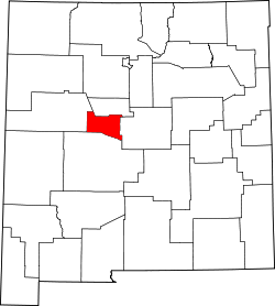
Monterey Park is a census-designated place in Valencia County, New Mexico, United States. Its population was 1,567 as of the 2010 census. [4] It is part of the Albuquerque Metropolitan Statistical Area.

Contents

The U.S. Census Bureau previously considered Monterey Park and the neighboring community of El Cerro Mission to be a single CDP, El Cerro-Monterey Park. The CDP was split prior to the 2010 Census. [5]

Demographics

Historical population
CensusPop.
2020 1,272
U.S. Decennial Census [6] [2]

Education

It is in the Los Lunas Public Schools school district. [7]

Related Research Articles

<span class="mw-page-title-main">Valencia County, New Mexico</span> County in New Mexico, United States

Valencia County is a county in the U.S. state of New Mexico. As of the 2010 census, the population was 76,569. The county seat is Los Lunas.

<span class="mw-page-title-main">Alondra Park, California</span> Census designated place in California, United States

Alondra Park, also known as El Camino Village, is a census designated place (CDP) in Los Angeles County, California, United States. It is the unincorporated area north of Alondra Community Regional Park and El Camino College. It is east of Lawndale, south of Hawthorne, west of Gardena, and north of Torrance. Manhattan Beach Boulevard and Crenshaw Boulevard are the two major cross streets in the area. The population was 8,569 at the 2020 census, down from 8,592 at the 2010 census. There is an official Alondra Park Post Office of the U.S. Postal Service in nearby Gardena, California. Urbanized cement-lined Dominguez Creek bisects a portion of Alondra Park.

<span class="mw-page-title-main">Aromas, California</span> Census-designated place in California, United States

Aromas is a census-designated place (CDP) in Monterey County and San Benito County, California, United States. The population was 2,650 at the 2010 census.

<span class="mw-page-title-main">Chaparral, New Mexico</span> Census-designated place in New Mexico, United States

Chaparral is an unincorporated community and census-designated place (CDP) in Doña Ana and Otero counties, New Mexico, United States. The population was 14,631 at the 2010 census. Chaparral is primarily a bedroom community for the neighboring city of El Paso, Texas, and the neighboring military installations of White Sands Missile Range and Fort Bliss. It is officially part of the Las Cruces Metropolitan Statistical Area.

<span class="mw-page-title-main">El Rancho, New Mexico</span> Census-designated place in New Mexico, United States

El Rancho is a census-designated place (CDP) in Santa Fe County, New Mexico, United States. It is part of the Santa Fe, New Mexico Metropolitan Statistical Area. The population was 1,199 at the 2010 census.

El Cerro Mission is a census-designated place (CDP) in Valencia County, New Mexico, United States. The population was 4,657 at the 2010 census. It is part of the Albuquerque Metropolitan Statistical Area.

<span class="mw-page-title-main">Jarales, New Mexico</span> CDP in New Mexico, United States

Jarales is a census-designated place (CDP) in Valencia County, New Mexico, United States. The population was 2,475 at the 2010 census. It is part of the Albuquerque Metropolitan Statistical Area.

<span class="mw-page-title-main">Meadow Lake, New Mexico</span> CDP in New Mexico, United States

Meadow Lake is a census-designated place (CDP) in Valencia County, New Mexico, United States. The population was 4,491 at the 2000 census. It is part of the Albuquerque Metropolitan Statistical Area.

<span class="mw-page-title-main">Peralta, New Mexico</span> Town in New Mexico, United States

Peralta is a town in Valencia County, New Mexico, United States. Prior to its incorporation on July 1, 2007, it was a census-designated place (CDP). The population was 3,660 as of the 2010 census. Peralta is part of the Albuquerque metropolitan area.

<span class="mw-page-title-main">Rio Communities, New Mexico</span> City in New Mexico, United States

Rio Communities is a city in Valencia County, New Mexico, United States. Prior to its incorporation on May 16, 2013, it was a census-designated place (CDP). The CDP population was 4,723 as of the 2010 census.

<span class="mw-page-title-main">Valencia, Valencia County, New Mexico</span> CDP in New Mexico, United States

Valencia is a census-designated place (CDP) in Valencia County, New Mexico, United States. The population was 2,192 at the 2010 census. It is part of the Albuquerque Metropolitan Statistical Area.

<span class="mw-page-title-main">Berwyn, Pennsylvania</span> Census-designated place in Pennsylvania, United States

Berwyn is a census-designated place (CDP) in Chester County, Pennsylvania. The population was 3,775 at the 2020 census. The area is part of the Philadelphia Main Line suburbs.

<span class="mw-page-title-main">Devon, Pennsylvania</span> Census-designated place in Pennsylvania, United States

Devon is a census-designated place (CDP) located in Tredyffrin and Easttown Township, Chester County, Pennsylvania. The population was 1,515 at the 2010 census. The area is part of the Philadelphia Main Line suburbs.

Los Lunas Public Schools is a school district based in Los Lunas, New Mexico.

<span class="mw-page-title-main">Fence Lake, New Mexico</span> Census-designated place in New Mexico, United States

Fence Lake is a census-designated place located in southwestern Cibola County, New Mexico, United States. Designated in 1980 by the United States Census Bureau, Fence Lake had a population of 42 as of the 2010 census. The area is largely ranchland, and there are few businesses there. It was named after a small village which is contained within its boundaries.

<span class="mw-page-title-main">Tome, New Mexico</span> Census-designated place in New Mexico, United States

Tome is an unincorporated village and census-designated place in Valencia County, New Mexico, United States. It is located in the Rio Grande valley near the foot of Tome Hill, a notable Catholic pilgrimage site. The village lies along New Mexico State Road 47 and is neighbored by Valencia to the north and Adelino to the south. It is the location of the Valencia Campus of the University of New Mexico. Tome has a post office with ZIP code 87060. The population was 1,867 as of the 2010 census.

<span class="mw-page-title-main">Adelino, New Mexico</span> Census-designated place in New Mexico, United States

Adelino is a census-designated place in Valencia County, New Mexico, United States. Its population was 783 as of the 2020 census. The Adelino CDP was first made in the 2010 census when it had a population of 823. Prior to 2010, the community was part of the Tome-Adelino CDP.

<span class="mw-page-title-main">El Castillo, Texas</span> CDP in Texas, United States

El Castillo is a census-designated place located in Starr County, Texas. It is a new CDP formed from part of the old La Victoria CDP for the 2010 census with a population of 188.

<span class="mw-page-title-main">El Cerro, New Mexico</span> Census-designated place in New Mexico, United States

El Cerro is a census-designated place in Valencia County, New Mexico, United States. Its population was 2,953 as of the 2010 census. It is part of the Albuquerque Metropolitan Statistical Area.

Valencia is an unincorporated community and census-designated place (CDP) in Santa Fe County, New Mexico, United States. It was first listed as a CDP prior to the 2020 census.

References

  1. "ArcGIS REST Services Directory". United States Census Bureau. Retrieved October 12, 2022.
  2. 1 2 "Census Population API". United States Census Bureau. Retrieved Oct 12, 2022.
  3. "Monterey Park". Geographic Names Information System . United States Geological Survey, United States Department of the Interior.
  4. "U.S. Census website". United States Census Bureau . Retrieved 2014-12-07.
  5. "2010 Place Relationship File". U.S. Census Bureau. Retrieved October 26, 2017.
  6. "Census of Population and Housing". Census.gov. Retrieved June 4, 2016.
  7. "2020 CENSUS - SCHOOL DISTRICT REFERENCE MAP: Valencia County, NM" (PDF). U.S. Census Bureau . Retrieved 2022-09-04.