Jarales, New Mexico

Last updated
Jarales, New Mexico
CDP
Jarales School, Jarales NM.jpg
Jarales School
Valencia County New Mexico Incorporated and Unincorporated areas Jarales Highlighted.svg
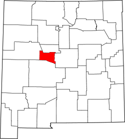
Location of Jarales, New Mexico
Usa edcp location map.svg
Red pog.svg
Jarales, New Mexico
Location in the United States
Coordinates: 34°35′59″N106°46′4″W / 34.59972°N 106.76778°W / 34.59972; -106.76778 Coordinates: 34°35′59″N106°46′4″W / 34.59972°N 106.76778°W / 34.59972; -106.76778
Country United States
State New Mexico
County Valencia
Area
[1]
  Total8.72 sq mi (22.58 km2)
  Land8.72 sq mi (22.58 km2)
  Water0.00 sq mi (0.00 km2)
Elevation
4,790 ft (1,460 m)
Population
 (2020) [2]
  Total2,042
  Density234.25/sq mi (90.45/km2)
Time zone UTC-7 (Mountain (MST))
  Summer (DST) UTC-6 (MDT)
ZIP code
87023
Area code 505
FIPS code 35-35110
GNIS feature ID0899685

Jarales is a census-designated place (CDP) in Valencia County, New Mexico, United States. The population was 2,475 at the 2010 census. [3] It is part of the Albuquerque Metropolitan Statistical Area.

Contents

Geography

Jarales is located at 34°35′59″N106°46′4″W / 34.59972°N 106.76778°W / 34.59972; -106.76778 (34.599825, -106.767856). [4]

According to the United States Census Bureau, the CDP has a total area of 8.7 square miles (23 km2), all land. [3]

Demographics

Historical population
CensusPop.
2020 2,042
U.S. Decennial Census [5] [2]

As of the census [6] of 2000, there were 1,434 people, 505 households, and 394 families residing in the CDP. The population density was 250.1 people per square mile (96.6/km2). There were 534 housing units at an average density of 93.1 per square mile (36.0/km2). The racial makeup of the CDP was 68.83% White, 0.63% African American, 0.91% Native American, 0.28% Asian, 25.52% from other races, and 3.84% from two or more races. Hispanic or Latino of any race were 64.57% of the population.

There were 505 households, out of which 35.8% had children under the age of 18 living with them, 61.2% were married couples living together, 9.9% had a female householder with no husband present, and 21.8% were non-families. 17.2% of all households were made up of individuals, and 6.3% had someone living alone who was 65 years of age or older. The average household size was 2.84 and the average family size was 3.20.

In the CDP, the population was spread out, with 29.4% under the age of 18, 7.3% from 18 to 24, 29.0% from 25 to 44, 24.5% from 45 to 64, and 9.8% who were 65 years of age or older. The median age was 35 years. For every 100 females, there were 99.2 males. For every 100 females age 18 and over, there were 99.2 males.

The median income for a household in the CDP was $26,897, and the median income for a family was $34,464. Males had a median income of $26,813 versus $15,909 for females. The per capita income for the CDP was $12,561. About 9.5% of families and 13.9% of the population were below the poverty line, including 15.9% of those under age 18 and 15.7% of those age 65 or over.

Education

Its school district is Belén Consolidated Schools. [7] Belén High School is the district's comprehensive high school.

Related Research Articles

<span class="mw-page-title-main">Valencia County, New Mexico</span> County in New Mexico, United States

Valencia County is a county in the U.S. state of New Mexico. As of the 2010 census, the population was 76,569. The county seat is Los Lunas.

<span class="mw-page-title-main">Meadow Lakes, Alaska</span> CDP in Alaska, United States

Meadow Lakes is a census-designated place (CDP) in Matanuska-Susitna Borough, Alaska, United States. Located west of Wasilla, it is part of the Anchorage, Alaska Metropolitan Statistical Area. As of the 2020 census, the population was 9,197, up from 7,570 in 2010. It is the fifth-most populated CDP in Alaska and the third largest community in the borough.

<span class="mw-page-title-main">Valencia West, Arizona</span> CDP in Pima County, Arizona

Valencia West is a census-designated place (CDP) in Pima County, Arizona, United States. The population was 9,355 at the 2010 census, a 293% increase over the population of 2,380 in 2000.

<span class="mw-page-title-main">West Falmouth, Massachusetts</span> Census-designated place in Massachusetts, United States

West Falmouth is a census-designated place (CDP) in the town of Falmouth in Barnstable County, Massachusetts, United States. The population was 1,738 at the 2010 census.

<span class="mw-page-title-main">Isleta Village Proper, New Mexico</span> Census-designated place in New Mexico, United States

Isleta Village Proper is a census-designated place (CDP) in Bernalillo County, New Mexico, United States. The population was 491 at the 2010 census. It is part of the Albuquerque Metropolitan Statistical Area.

<span class="mw-page-title-main">Peña Blanca, New Mexico</span> CDP in New Mexico, United States

Peña Blanca is a census-designated place (CDP) in Sandoval County, New Mexico. As of the 2000 census, the CDP population was 661. It is part of the Albuquerque Metropolitan Statistical Area.

<span class="mw-page-title-main">San Felipe Pueblo, New Mexico</span> CDP in New Mexico, United States

San Felipe Pueblo is a census-designated place (CDP) in Sandoval County, New Mexico, United States, and is located 10 miles (16 km) north of Bernalillo. As of the 2000 census, the CDP population was 2,080. It is part of the Albuquerque Metropolitan Statistical Area.

<span class="mw-page-title-main">Casa Colorada, New Mexico</span> CDP in New Mexico, United States

Casa Colorada is a census-designated place (CDP) in Valencia County, New Mexico, United States. The population was 272 at the 2010 census. It is part of the Albuquerque Metropolitan Statistical Area.

<span class="mw-page-title-main">Los Chavez, New Mexico</span> CDP in New Mexico, United States

Los Chavez is a census-designated place (CDP) in Valencia County, New Mexico. The population was 5,033 at the time of the 2000 census. It is part of the Albuquerque Metropolitan Statistical Area.

<span class="mw-page-title-main">Los Trujillos-Gabaldon, New Mexico</span> CDP in New Mexico, United States

Los Trujillos-Gabaldon is a census-designated place (CDP) in Valencia County, New Mexico, United States. The population was 2,166 at the 2000 census. It is part of the Albuquerque Metropolitan Statistical Area.

<span class="mw-page-title-main">Meadow Lake, New Mexico</span> CDP in New Mexico, United States

Meadow Lake is a census-designated place (CDP) in Valencia County, New Mexico, United States. The population was 4,491 at the 2000 census. It is part of the Albuquerque Metropolitan Statistical Area.

<span class="mw-page-title-main">Peralta, New Mexico</span> Town in New Mexico, United States

Peralta is a town in Valencia County, New Mexico, United States. Prior to its incorporation on July 1, 2007, it was a census-designated place (CDP). The population was 3,660 as of the 2010 census. Peralta is part of the Albuquerque metropolitan area.

<span class="mw-page-title-main">Rio Communities, New Mexico</span> City in New Mexico, United States

Rio Communities is a city in Valencia County, New Mexico, United States. Prior to its incorporation on May 16, 2013, it was a census-designated place (CDP). The CDP population was 4,723 as of the 2010 census.

<span class="mw-page-title-main">Rio Communities North, New Mexico</span> CDP in New Mexico, United States

Rio Communities North is a census-designated place (CDP) in Valencia County, New Mexico, United States. The population was 1,588 at the 2000 census. It is part of the Albuquerque Metropolitan Statistical Area.

<span class="mw-page-title-main">Tome-Adelino, New Mexico</span> Former Census-designated place in New Mexico, United States

Tome-Adelino is a former census-designated place (CDP) in Valencia County, New Mexico, United States. The population was 2,211 at the 2000 census. It is part of the Albuquerque Metropolitan Statistical Area. For the 2010 census, the CDP was split into the census-designated places of Tome and Adelino.

<span class="mw-page-title-main">Valencia, Valencia County, New Mexico</span> CDP in New Mexico, United States

Valencia is a census-designated place (CDP) in Valencia County, New Mexico, United States. The population was 2,192 at the 2010 census. It is part of the Albuquerque Metropolitan Statistical Area.

<span class="mw-page-title-main">Rocky Mountain, Oklahoma</span> Census-designated place in Oklahoma, United States

Rocky Mountain is a census-designated place (CDP) in Adair County, Oklahoma, United States. The population was 420 at the 2010 census.

Forestville is a census-designated place (CDP) in Schuylkill County, Pennsylvania, United States. The population was 431 at the 2000 census.

<span class="mw-page-title-main">Santa Cruz, Texas</span> Former CDP in Texas, United States

Santa Cruz is a former census-designated place (CDP) in Starr County, Texas, United States. The population was 630 at the 2000 census. Prior to the 2010 census, this CDP was deleted and parts were taken to form El Chaparral and Santa Rosa CDPs. A new CDP of the same name was created that does not contain any part of the old CDP.

<span class="mw-page-title-main">Fort Fairfield (CDP), Maine</span> Census-designated place in Maine, United States

Fort Fairfield is a census-designated place (CDP) comprising the main village within the town of Fort Fairfield in Aroostook County, Maine, United States. The population of the CDP was 1,825 at the 2010 census, out of a population of 3,496 for the entire town.

References

  1. "ArcGIS REST Services Directory". United States Census Bureau. Retrieved October 12, 2022.
  2. 1 2 "Census Population API". United States Census Bureau. Retrieved Oct 12, 2022.
  3. 1 2 "2010 Census Gazetteer Files - Places: New Mexico". U.S. Census Bureau . Retrieved October 20, 2017.
  4. "US Gazetteer files: 2010, 2000, and 1990". United States Census Bureau. 2011-02-12. Retrieved 2011-04-23.
  5. "Census of Population and Housing". Census.gov. Retrieved June 4, 2016.
  6. "U.S. Census website". United States Census Bureau . Retrieved 2008-01-31.
  7. "2020 CENSUS - SCHOOL DISTRICT REFERENCE MAP: Valencia County, NM" (PDF). U.S. Census Bureau . Retrieved 2022-09-04.