Los Chavez, New Mexico | |
---|---|
Coordinates: 34°43′33″N106°45′26″W / 34.72583°N 106.75722°W | |
Country | United States |
State | New Mexico |
County | Valencia |
Area | |
• Total | 11.44 sq mi (29.64 km2) |
• Land | 11.44 sq mi (29.64 km2) |
• Water | 0.00 sq mi (0.00 km2) |
Elevation | 4,823 ft (1,470 m) |
Population | |
• Total | 4,997 |
• Density | 436.65/sq mi (168.59/km2) |
Time zone | UTC-7 (Mountain (MST)) |
• Summer (DST) | UTC-6 (MDT) |
Area code | 505 |
FIPS code | 35-42740 |
GNIS feature ID | 0930475 [2] |
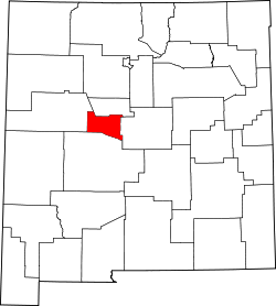
Los Chavez is a census-designated place (CDP) in Valencia County, New Mexico. The population was 5,033 at the time of the 2000 census. It is part of the Albuquerque Metropolitan Statistical Area.
The settlement of Los Chávez, on the west bank of the Río Grande, dates to a 1738 grant to Nicolás Durán y Chávez from Atrisco. In 1790, it consisted of six plazas (Julyan 1996:78; Espinosa and Chávez 1967:41- 43). It was included in the 1802 census (Olmsted 1981:139-140). In the autumn of 1847, a unit of the U.S. Army traveled south along the west bank of the Río Grande. Philip Gooch Ferguson reported that “the road most generally traveled” was on the east bank, but the west side of the river was better for water. Ferguson mentioned camping near a small town named “Plaza Chavez” (Bieber 1936:326-328). [4]
According to the United States Census Bureau, the CDP has a total area of 10.2 square miles (26 km2), all land.
Census | Pop. | Note | %± |
---|---|---|---|
2020 | 4,997 | — | |
U.S. Decennial Census [5] [3] |
As of the census [6] of 2000, there were 5,033 people, 1,764 households, and 1,365 families residing in the CDP. The population density was 491.7 inhabitants per square mile (189.8/km2). There were 1,888 housing units at an average density of 184.4 units per square mile (71.2 units/km2). The racial makeup of the CDP was 66.42% White, 0.60% African American, 1.27% Native American, 0.20% Asian, 0.02% Pacific Islander, 26.43% from other races, and 5.07% from two or more races. Hispanic or Latino of any race were 54.10% of the population.
There were 1,764 households, out of which 40.1% had children under the age of 18 living with them, 58.7% were married couples living together, 13.2% had a female householder with no husband present, and 22.6% were non-families. 17.2% of all households were made up of individuals, and 5.4% had someone living alone who was 65 years of age or older. The average household size was 2.85 and the average family size was 3.21.
In the CDP, the population was spread out, with 30.0% under the age of 18, 7.4% from 18 to 24, 30.5% from 25 to 44, 23.5% from 45 to 64, and 8.6% who were 65 years of age or older. The median age was 35 years. For every 100 females, there were 99.6 males. For every 100 females age 18 and over, there were 95.4 males.
The median income for a household in the CDP was $38,228, and the median income for a family was $40,896. Males had a median income of $32,278 versus $22,537 for females. The per capita income for the CDP was $16,092. About 13.1% of families and 15.8% of the population were below the poverty line, including 20.3% of those under age 18 and 12.7% of those age 65 or over.
The majority of Los Chavez is in Belen Consolidated Schools, while a portion is in Los Lunas Public Schools. [7] Belén High School is the Belén district's comprehensive high school.
Valencia County is a county in the U.S. state of New Mexico. As of the 2020 census, the population was 76,205. The county seat is Los Lunas.
Valencia West is a census-designated place (CDP) in Pima County, Arizona, United States. The population was 9,355 at the 2010 census, a 293% increase over the population of 2,380 in 2000.
Del Aire is a census-designated place (CDP) in the inland South Bay, Los Angeles County, California, United States, between El Segundo and Hawthorne. The population was 10,001 at the 2010 census, up from 9,012 at the 2000 census.
Pebble Creek is a census-designated place (CDP) in Hillsborough County, Florida, United States. The population was 9,624 at the 2020 census, up from 7,622 at the 2010 census. Pebble Creek is located in the unincorporated portion of New Tampa, and is primarily a residential zone.
Naschitti is a census-designated place (CDP) in San Juan County, New Mexico, United States. The population was 360 at the 2000 census. It is part of the Farmington Metropolitan Statistical Area. The town was established in 1886, when Tom Bryan set up a trading post east of the Chuska Mountains. With a Navajo name, Naschitti means "badger springs."
Cañada de los Alamos is a census-designated place (CDP) in Santa Fe County, New Mexico, United States. It is part of the Santa Fe, New Mexico Metropolitan Statistical Area. The population was 434 at the 2010 census.
El Rancho is a census-designated place (CDP) in Santa Fe County, New Mexico, United States. It is part of the Santa Fe, New Mexico Metropolitan Statistical Area. The population was 1,199 at the 2010 census.
El Valle de Arroyo Seco is a census-designated place (CDP) in Santa Fe County, New Mexico, United States. It is part of the Santa Fe, New Mexico Metropolitan Statistical Area. The population was 1,440 at the 2010 census.
Casa Colorada is a census-designated place (CDP) in Valencia County, New Mexico, United States. The population was 272 at the 2010 census. It is part of the Albuquerque Metropolitan Statistical Area.
Jarales is a census-designated place (CDP) in Valencia County, New Mexico, United States. The population was 2,475 at the 2010 census. It is part of the Albuquerque Metropolitan Statistical Area.
Los Trujillos-Gabaldon is a census-designated place (CDP) in Valencia County, New Mexico, United States. The population was 2,166 at the 2000 census. It is part of the Albuquerque Metropolitan Statistical Area.
Meadow Lake is a census-designated place (CDP) in Valencia County, New Mexico, United States. The population was 4,491 at the 2000 census. It is part of the Albuquerque Metropolitan Statistical Area.
Peralta is a town in Valencia County, New Mexico, United States. Prior to its incorporation on July 1, 2007, it was a census-designated place (CDP). The population was 3,660 as of the 2010 census. Peralta is part of the Albuquerque metropolitan area.
Rio Communities is a city in Valencia County, New Mexico, United States. Prior to its incorporation on May 16, 2013, it was a census-designated place (CDP). The CDP population was 4,723 as of the 2010 census.
Rio Communities North is a census-designated place (CDP) in Valencia County, New Mexico, United States. The population was 1,588 at the 2000 census. It is part of the Albuquerque Metropolitan Statistical Area.
Tome-Adelino is a former census-designated place (CDP) in Valencia County, New Mexico, United States. The population was 2,211 at the 2000 census. It is part of the Albuquerque Metropolitan Statistical Area. For the 2010 census, the CDP was split into the census-designated places of Tome and Adelino.
Valencia is a census-designated place (CDP) in Valencia County, New Mexico, United States. The population was 2,192 according to the 2010 census. It is part of the Albuquerque Metropolitan Statistical Area.
Pleasant Run is a census-designated place (CDP) in Colerain Township, Hamilton County, Ohio, United States. The population was 4,861 at the 2020 census.
Sturgeon-Noblestown was a census-designated place (CDP) for the 2000 United States Census in Allegheny County, Pennsylvania, United States. The population was 1,764 at that time. In the 2010 census the CDP was split into the two separate CDP's of Sturgeon and Noblestown.
Ranchettes is a census-designated place (CDP) in Laramie County, Wyoming, United States. It is part of the Cheyenne, Wyoming Metropolitan Statistical Area. The population was 5,798 at the 2010 census.