Pueblitos, New Mexico | |
|---|---|
 Pueblitos | |
| Coordinates: 34°37′23″N106°46′45″W / 34.62306°N 106.77917°W | |
| Country | United States |
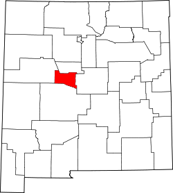
| State | New Mexico |
| County | Valencia |
| Area | |
• Total | 2.13 sq mi (5.52 km2) |
| • Land | 2.13 sq mi (5.51 km2) |
| • Water | 0.0039 sq mi (0.01 km2) |
| Elevation | 4,800 ft (1,500 m) |
| Population | |
• Total | 540 |
| • Density | 253.9/sq mi (98.04/km2) |
| Time zone | UTC-7 (Mountain (MST)) |
| • Summer (DST) | UTC-6 (MDT) |
| Area code | 505 |
| GNIS feature ID | 2584186 [2] |
Pueblitos is a census-designated place in Valencia County, New Mexico, United States. Its population was 794 as of the 2010 census. [4] New Mexico State Road 116 passes through the community.