Los Trujillos-Gabaldon, New Mexico

Last updated

Los Trujillos-Gabaldon, New Mexico
CDP
Valencia County New Mexico Incorporated and Unincorporated areas Los Trujillos-Gabaldon Highlighted.svg
Location of Los Trujillos-Gabaldon, New Mexico
Usa edcp location map.svg
Red pog.svg
Los Trujillos-Gabaldon, New Mexico
Location in the United States
Coordinates: 34°39′47″N106°45′21″W / 34.66306°N 106.75583°W / 34.66306; -106.75583
Country United States
State New Mexico
County Valencia
Area
  Total5.9 sq mi (15.4 km2)
  Land5.9 sq mi (15.4 km2)
  Water0.0 sq mi (0.0 km2)
Elevation
[1]
4,807 ft (1,465 m)
Population
 (2000)
  Total2,166
  Density364.9/sq mi (140.9/km2)
Time zone UTC-7 (Mountain (MST))
  Summer (DST) UTC-6 (MDT)
Area code 505
FIPS code 35-44145
GNIS feature ID2408139 [1]

Los Trujillos-Gabaldon is a census-designated place (CDP) in Valencia County, New Mexico, United States. The population was 2,166 at the 2000 census. It is part of the Albuquerque Metropolitan Statistical Area.

Contents

Geography

According to the United States Census Bureau, the CDP has a total area of 5.9 square miles (15 km2), all land.

Demographics

As of the census of 2000, there were 2,166 people, 804 households, and 598 families residing in the CDP. The population density was 364.9 inhabitants per square mile (140.9/km2). There were 870 housing units at an average density of 146.6 units per square mile (56.6 units/km2). The racial makeup of the CDP was 71.93% White, 1.15% African American, 2.31% Native American, 0.18% Asian, 19.62% from other races, and 4.80% from two or more races. Hispanic or Latino of any race were 62.47% of the population.

There were 804 households, out of which 32.3% had children under the age of 18 living with them, 56.3% were married couples living together, 12.9% had a female householder with no husband present, and 25.6% were non-families. 20.0% of all households were made up of individuals, and 7.1% had someone living alone who was 65 years of age or older. The average household size was 2.69 and the average family size was 3.09.

In the CDP, the population was spread out, with 26.4% under the age of 18, 8.9% from 18 to 24, 26.8% from 25 to 44, 25.2% from 45 to 64, and 12.8% who were 65 years of age or older. The median age was 37 years. For every 100 females, there were 97.8 males. For every 100 females age 18 and over, there were 99.1 males.

The median income for a household in the CDP was $28,989, and the median income for a family was $35,433. Males had a median income of $28,661 versus $21,492 for females. The per capita income for the CDP was $13,959. About 12.8% of families and 15.4% of the population were below the poverty line, including 17.4% of those under age 18 and 16.9% of those age 65 or over.

Related Research Articles

<span class="mw-page-title-main">Drexel-Alvernon, Arizona</span> CDP in Pima County, Arizona

Drexel-Alvernon was a census-designated place (CDP) in Pima County, Arizona, United States. The population was 4,192 at the 2000 census.

<span class="mw-page-title-main">Pine Hills, California</span> Census-designated place in California, United States

Pine Hills is a census-designated place (CDP) in Humboldt County, California, United States, adjacent to Eureka. The population was 3,131 at the 2010 census, up from 3,108 at the 2000 census. Pine Hills includes areas like Ridgewood and areas as far south as the small neighborhood of Elk River. An area near this artificial census construct is called Pine Hill by Local government agencies and officials. Pine Hill is a much smaller area than "Pine Hills" and as defined by local agencies is actually within an adjacent CDP named Bayview.

<span class="mw-page-title-main">South San Gabriel, California</span> Census-designated place in California, United States

South San Gabriel is a census-designated place (CDP) in Los Angeles County, California, United States. The population was 8,070 at the 2010 census, up from 7,595 at the 2000 census.

<span class="mw-page-title-main">Toro Canyon, California</span> Census-designated place in California, United States

Toro Canyon is a census-designated place (CDP) in Santa Barbara County, California, United States. The population was 1,835 at the 2020 census, up from 1,508 at the 2010 census.

<span class="mw-page-title-main">Pelican Bay, Florida</span> Census-designated place in Florida

Pelican Bay is a census-designated place (CDP) in Collier County, Florida, United States. The population was 6,660 at the 2020 census, up from 6,346 at the 2010 census. It is part of the Naples–Marco Island Metropolitan Statistical Area.

<span class="mw-page-title-main">Vineyards, Florida</span> Census-designated place in Florida, United States

Vineyards is a census-designated place (CDP) in Collier County, Florida, United States. The population was 3,883 at the 2020 census, up from 3,375 at the 2010 census. It is part of the Naples–Marco Island Metropolitan Statistical Area.

<span class="mw-page-title-main">Eastpoint, Florida</span> CDP in Florida, United States

Eastpoint is a census-designated place (CDP) in Franklin County, Florida, United States. The population was 2,337 at the 2010 census.

<span class="mw-page-title-main">West Ishpeming, Michigan</span> Census-designated place & unincorporated community in Michigan, United States

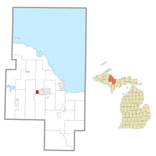
West Ishpeming is an unincorporated community and census-designated place (CDP) in Marquette County in the U.S. state of Michigan. The population was 2,552 at the 2020 census. The community is located mostly within Ishpeming Township with a small portion extending south into Tilden Township.

<span class="mw-page-title-main">Heathcote, New Jersey</span> Populated place in Middlesex County, New Jersey, US

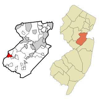
Heathcote is an unincorporated community and census-designated place (CDP) located within South Brunswick, in Middlesex County, in the U.S. state of New Jersey. As of the 2010 United States Census, the CDP's population was 5,821.

<span class="mw-page-title-main">Holiday Heights, New Jersey</span> Populated place in Ocean County, New Jersey, US

Holiday Heights is an unincorporated community and census-designated place (CDP) located within Berkeley Township, in Ocean County, in the U.S. state of New Jersey. As of the 2010 United States Census, the CDP's population was 2,099.

<span class="mw-page-title-main">Mesita, New Mexico</span> Census-designated place in New Mexico, United States

Mesita is a census-designated place (CDP) in Cibola County, New Mexico, United States. The population was 804 at the 2010 census.

Medusa is a hamlet in the Town of Rensselaerville, in Albany County, New York, United States. The population was 376 at the 2000 census, which listed the community as a census-designated place (CDP), but it was not included as a CDP in the 2010 census.

West End is an unincorporated suburban community in Otsego County, New York, United States. The population was 1,940 at the 2010 census.

<span class="mw-page-title-main">Northbrook, Ohio</span> Census-designated place in Ohio, United States

Northbrook is a census-designated place (CDP) in Hamilton County, Ohio, United States. The population was 10,912 at the 2020 census.

<span class="mw-page-title-main">Sherwood, Hamilton County, Ohio</span> Census-designated place in Ohio, United States

Sherwood is a census-designated place (CDP) in Hamilton County, Ohio, United States. The population was 3,633 at the 2020 census.

<span class="mw-page-title-main">Elim, Pennsylvania</span> Census-designated place in Pennsylvania, United States

Elim is an unincorporated community and census-designated place (CDP) in Upper Yoder Township, Cambria County, Pennsylvania, United States. The population was 3,727 at the 2010 census, down from 4,175 at the 2000 census.

Eastlawn Gardens is a census-designated place (CDP) in Upper Nazareth Township in Northampton County, Pennsylvania, United States. The population of Eastlawn Gardens was 3,307 at the 2010 census. Eastlawn Gardens is part of the Lehigh Valley metropolitan area, which had a population of 861,899 and was the 68th-most populous metropolitan area in the U.S. as of the 2020 census.

<span class="mw-page-title-main">Geneva, Washington</span> CDP in Washington, United States

Geneva is an unincorporated area and census-designated place (CDP) in Whatcom County, Washington, United States. The population was 2,652 at the 2020 census.

<span class="mw-page-title-main">Loveland Park, Ohio</span> Census-designated place in Ohio, United States

Loveland Park is a census-designated place (CDP) located in Symmes Township, Hamilton County and Deerfield Township, Warren County, in the southwestern part of the U.S. state of Ohio. The CDP is named after the city of Loveland. The population was 1,737 at the 2020 census.

<span class="mw-page-title-main">Freeport (CDP), Maine</span> Census-designated place in Maine, United States

Freeport is a census-designated place (CDP) in the town of Freeport in Cumberland County, Maine, United States. The population was 1,485 at the 2010 census. It is part of the Portland–South Portland–Biddeford, Maine Metropolitan Statistical Area.

References

  1. 1 2 U.S. Geological Survey Geographic Names Information System: Los Trujillos-Gabaldon, New Mexico