Valencia, Valencia County, New Mexico

Last updated

Valencia, New Mexico
CDP
Valencia historic marker, Valencia NM.jpg
Valencia historic marker
Valencia County New Mexico Incorporated and Unincorporated areas Valencia Highlighted.svg
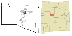
Location of Valencia, New Mexico
Usa edcp location map.svg
Red pog.svg
Valencia, New Mexico
Location in the United States
Coordinates: 34°48′19″N106°41′13″W / 34.80528°N 106.68694°W / 34.80528; -106.68694
Country United States
State New Mexico
County Valencia
Area
[1]
  Total
1.98 sq mi (5.14 km2)
  Land1.98 sq mi (5.14 km2)
  Water0.00 sq mi (0.00 km2)
Elevation
[2]
4,849 ft (1,478 m)
Population
 (2020) [3]
  Total
2,052
  Density1,034.27/sq mi (399.38/km2)
Time zone UTC-7 (Mountain (MST))
  Summer (DST) UTC-6 (MDT)
Area code 505
FIPS code 35-81800
GNIS feature ID2409390 [2]

Valencia is a census-designated place (CDP) in Valencia County, New Mexico, United States. The population was 2,192 according to the 2010 census. It is part of the Albuquerque Metropolitan Statistical Area.

Contents

Geography

According to the United States Census Bureau, the CDP has a total area of 5.5 square miles (14 km2), all land.

Demographics

Historical population
CensusPop.Note
1990 3,917
2000 4,50014.9%
2010 2,192−51.3%
2020 2,052−6.4%
U.S. Decennial Census [3]

As of the census [4] of 2000, there were 4,500 people, 1,553 households, and 1,248 families residing in the CDP. The population density was 819.4 inhabitants per square mile (316.4/km2). There were 1,646 housing units at an average density of 299.7 per square mile (115.7/km2). The racial makeup of the CDP was 68.87% White, 0.76% African American, 1.93% Native American, 0.67% Asian, 0.09% Pacific Islander, 23.07% from other races, and 4.62% from two or more races. Hispanic or Latino individuals of any race made up 49.67% of the population.

There were 1,553 households, of which 37.1% had children under the age of 18 living with them; 63.0% were married couples living together, 11.4% had a female householder with no husband present, and 19.6% were non-families. 15.4% of all households were made up of individuals, and 4.2% had someone living alone who was 65 years of age or older. The average household size was 2.87 and the average family size was 3.17.

In the CDP, the population was spread out, with 27.9% under the age of 18, 8.0% from 18 to 24, 28.5% from 25 to 44, 25.5% from 45 to 64, and 10.1% who were 65 years of age or older. The median age was 37 years. For every 100 females, there were 98.3 males. For every 100 females age 18 and over, there were 95.0 males.

The median income for a household in the CDP was $40,521, and the median family income was $47,745. Males had a median income of $38,939 versus $24,830 for females. The per capita income for the CDP was $16,620. About 8.5% of families and 12.0% of the population were below the poverty line, including 16.0% of those under age 18 and 9.9% of those age 65 or over.

Education

The community's public schools are operated by Los Lunas Schools district. [5]

Related Research Articles

<span class="mw-page-title-main">Mount Olive, Jefferson County, Alabama</span> Unincorporated community in Alabama, United States

Mount Olive, also spelled Mt. Olive is an unincorporated community and a census-designated place (CDP) in Jefferson County, Alabama. Its location is in the suburbs of Birmingham. As of the 2010 census, the population of the community is 4,079. Mount Olive is bordered on the south and the east by the town of Gardendale, and in fact, some areas that had previously been in Mount Olive have been annexed into Gardendale over the years. Running along part of the border between Mt. Olive and Gardendale is the major expressway, Interstate 65. Eventually, part of Birmingham's Northern Beltline will cut through northwestern sections of Mt. Olive. Mt. Olive has its own elementary school, and was formerly the home of a junior high school.

<span class="mw-page-title-main">Valencia West, Arizona</span> CDP in Pima County, Arizona

Valencia West is a census-designated place (CDP) in Pima County, Arizona, United States. The population was 9,355 at the 2010 census, a 293% increase over the population of 2,380 in 2000.

<span class="mw-page-title-main">Las Flores, California</span> Place in California, United States

Las Flores is an unincorporated census-designated place (CDP) in Orange County, California, located adjacent to the City of Rancho Santa Margarita, California. The population was 5,971 at the 2010 census, up from 5,625 at the 2000 census. Las Flores does not have its own ZIP Code and is served by the same ZIP Code as adjacent Rancho Santa Margarita, 92688. The Rancho Santa Margarita dog/skate park is located in the CDP and is served by the Orange County Sheriff's Dept. and Orange County Fire Authority. Although Las Flores lies in the land grant of Rancho Mission Viejo, it is named after the land grant about twenty-five miles (40 km) south Rancho Santa Margarita y Las Flores.

<span class="mw-page-title-main">North Auburn, California</span> Census-designated place in California, United States

North Auburn is a census-designated place (CDP) in Placer County, California, United States. It is part of the Sacramento–Arden-Arcade–Roseville Metropolitan Statistical Area. The population was 13,452 at the 2020 census.

<span class="mw-page-title-main">Home Gardens, California</span> Census-designated place in California, United States

Home Gardens is a census-designated place (CDP) in Riverside County, California, United States. It is within the City of Corona's sphere of influence. The population was 11,203 at the 2020 census, down from 11,507 at the 2010 census.

<span class="mw-page-title-main">Shackelford, California</span> Neighbourhood in Stanislaus, California, United States

Shackelford is a southern neighbourhood of the city of Modesto in Stanislaus County, California, United States, which was officially annexed on June 1, 2012. The population was 3,371 at the 2010 census, down from 5,170 at the 2000 census. It is part of the Modesto Metropolitan Statistical Area. Prior to its annexation, the neighbourhood was a census-designated place (CDP).

<span class="mw-page-title-main">McGregor, Florida</span> Census-designated place in Florida, United States

McGregor is a census-designated place (CDP) in Lee County, Florida, United States. The population was 7,976 at the 2020 census, up from 7,406 at the 2010 census. It is part of the Cape Coral-Fort Myers, Florida Metropolitan Statistical Area.

<span class="mw-page-title-main">North River Shores, Florida</span> Census-designated place in Florida, United States

North River Shores is an unincorporated area and census-designated place (CDP) in Martin County, Florida, United States. The population was 3,459 at the 2020 census, up from 3,079 in 2010. It is part of the Port St. Lucie Metropolitan Statistical Area.

<span class="mw-page-title-main">Stony Point, Michigan</span> Census-designated place & unincorporated community in Michigan, United States

Stony Point is an unincorporated community and census-designated place (CDP) in Monroe County in the U.S. state of Michigan. The population was 1,784 at the 2020 census. The CDP is located within Frenchtown Charter Township.

<span class="mw-page-title-main">Jarales, New Mexico</span> CDP in New Mexico, United States

Jarales is a census-designated place (CDP) in Valencia County, New Mexico, United States. The population was 2,475 at the 2010 census. It is part of the Albuquerque Metropolitan Statistical Area.

<span class="mw-page-title-main">Meadow Lake, New Mexico</span> CDP in New Mexico, United States

Meadow Lake is a census-designated place (CDP) in Valencia County, New Mexico, United States. The population was 4,491 at the 2000 census. It is part of the Albuquerque Metropolitan Statistical Area.

<span class="mw-page-title-main">Peralta, New Mexico</span> Town in New Mexico, United States

Peralta is a town in Valencia County, New Mexico, United States. Prior to its incorporation on July 1, 2007, it was a census-designated place (CDP). The population was 3,660 as of the 2010 census. Peralta is part of the Albuquerque metropolitan area.

<span class="mw-page-title-main">Rio Communities North, New Mexico</span> CDP in New Mexico, United States

Rio Communities North is a census-designated place (CDP) in Valencia County, New Mexico, United States. The population was 1,588 at the 2000 census. It is part of the Albuquerque Metropolitan Statistical Area.

<span class="mw-page-title-main">Tome-Adelino, New Mexico</span> Former Census-designated place in New Mexico, United States

Tome-Adelino is a former census-designated place (CDP) in Valencia County, New Mexico, United States. The population was 2,211 at the 2000 census. It is part of the Albuquerque Metropolitan Statistical Area. For the 2010 census, the CDP was split into the census-designated places of Tome and Adelino.

<span class="mw-page-title-main">Dry Run, Ohio</span> Census-designated place in Ohio, United States

Dry Run is a census-designated place (CDP) in Anderson Township, Hamilton County, Ohio, United States. The population was 7,672 at the 2020 census.

<span class="mw-page-title-main">Harbeck-Fruitdale, Oregon</span> Unincorporated community in the state of Oregon, United States

Harbeck-Fruitdale was formerly a census-designated place (CDP) in Josephine County, Oregon, United States, near Grants Pass. As of the 2000 census, the CDP population was 3,780. It includes the community of Fruitdale.

Westlake Corner is a census-designated place in Franklin County, Virginia, United States. The population was 1,553 at the 2020 census up from 976 at the 2010 census. It is part of the Roanoke Metropolitan Statistical Area.

<span class="mw-page-title-main">Ethete, Wyoming</span> CDP in Wyoming, United States

Ethete is a census-designated place (CDP) in Fremont County, Wyoming, United States. The population was 1,553 at the 2010 census. The town is located on the Wind River Indian Reservation. It grew up around the Episcopal St. Michael's Mission.

<span class="mw-page-title-main">South Greeley, Wyoming</span> Census-designated place in Wyoming, United States

South Greeley is a census-designated place (CDP) in Laramie County, Wyoming, United States. It is part of the Cheyenne, Wyoming Metropolitan Statistical Area. The population was 4,733 at the 2020 census. The population was 4,217 at the 2010 census.

<span class="mw-page-title-main">Loveland Park, Ohio</span> Census-designated place in Ohio, United States

Loveland Park is a census-designated place (CDP) located in Symmes Township, Hamilton County and Deerfield Township, Warren County, in the southwestern part of the U.S. state of Ohio. The CDP is named after the city of Loveland. The population was 1,737 at the 2020 census.

References

  1. "ArcGIS REST Services Directory". United States Census Bureau. Retrieved October 12, 2022.
  2. 1 2 U.S. Geological Survey Geographic Names Information System: Valencia, Valencia County, New Mexico
  3. 1 2 "Census Population API". United States Census Bureau. Retrieved October 12, 2022.
  4. "U.S. Census website". United States Census Bureau . Retrieved January 31, 2008.
  5. "2020 CENSUS - SCHOOL DISTRICT REFERENCE MAP: Valencia County, NM" (PDF). U.S. Census Bureau . Retrieved September 4, 2022.