Chipaya | |
|---|---|
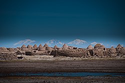 The ancient Chipaya village | |
 Interactive map of Chipaya | |
| Coordinates: 19°03′S68°05′W / 19.050°S 68.083°W | |
| Country | |
| Department | Oruro |
| Province | Sabaya Province |
| Municipality | Chipaya Municipality |
| Population (2001) | |
• Total | 363 |
| Time zone | UTC-4 (BOT) |
Chipaya is a village in Bolivia located in the Sabaya Province (formerly Atahuallpa Province) of the Oruro Department. It is the seat of the Chipaya Municipality. In 2001 it had a population of 363. [1] The village is situated in a remote area northeast of Lake Coipasa [2] where the people have maintained special elements of their culture.
Contents
Chipaya was declared a National Monument by Supreme Decrete No. 8171 on December 7, 1967. [3]

