Chloride | |
|---|---|
 The buildings of Chloride look much as they have for the past 100 years. Once a booming silver mining town, few buildings remain. | |
 Chloride Location within the state of New Mexico  Chloride Chloride (the United States) | |
| Coordinates: 33°20′19″N107°40′40″W / 33.33861°N 107.67778°W | |
| Country | United States |
| State | New Mexico |
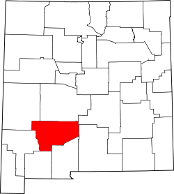
| County | Sierra |
| Elevation | 6,181 ft (1,884 m) |
| Time zone | UTC-7 (Mountain (MST)) |
| • Summer (DST) | UTC-6 (MDT) |
| GNIS feature ID | 905118 [1] |
Chloride is an unincorporated community in Sierra County, in the U.S. state of New Mexico. [1] The community is located at the confluence of Chloride Creek with Mineral Creek. Most of the old mine workings are to the west, along Chloride Creek. [2] Winston is approximately two miles to the east. [2]