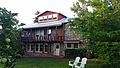
Kingston, New Mexico | |
|---|---|
Census-designated place | |
 Kingston, New Mexico | |
 Kingston, New Mexico | |
| Coordinates: 32°55′02″N107°42′34″W / 32.91722°N 107.70944°W | |
| Country | United States |
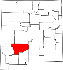
| State | New Mexico |
| County | Sierra |
| Area | |
• Total | 0.20 sq mi (0.52 km2) |
| • Land | 0.20 sq mi (0.52 km2) |
| • Water | 0.00 sq mi (0.00 km2) |
| Elevation | 6,240 ft (1,900 m) |
| Population | |
• Total | 50 |
| • Density | 251.26/sq mi (96.98/km2) |
| Time zone | UTC-7 (Mountain (MST)) |
| • Summer (DST) | UTC-6 (MDT) |
| Area code | 575 |
| GNIS feature ID | 2584118 [2] |
Kingston is a census-designated place (CDP) in Sierra County, New Mexico, United States. Its population was 32 as of the 2010 census. [4] The community is located in the Black Range along New Mexico State Road 152.