Winston, New Mexico | |
|---|---|
Census-designated place | |
 Winston General Store | |
 Winston, New Mexico | |
| Coordinates: 33°20′46″N107°38′55″W / 33.34611°N 107.64861°W | |
| Country | United States |
| State | New Mexico |
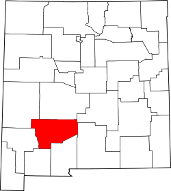
| County | Sierra |
| Area | |
• Total | 0.42 sq mi (1.09 km2) |
| • Land | 0.42 sq mi (1.09 km2) |
| • Water | 0 sq mi (0.00 km2) |
| Elevation | 6,175 ft (1,882 m) |
| Population | |
• Total | 47 |
| • Density | 112.2/sq mi (43.31/km2) |
| Time zone | UTC-7 (Mountain (MST)) |
| • Summer (DST) | UTC-6 (MDT) |
| ZIP code | 87943 |
| Area code | 575 |
| GNIS feature ID | 2584240 [2] |
Winston is a census-designated place in Sierra County, New Mexico, United States. Its population was 61 as of the 2010 census. [4] Winston has a post office with ZIP code 87943, which opened on August 15, 1881. [5] [6] The community was named for Frank Winston, a pioneer miner. [7] New Mexico State Road 52 passes through the community.