Engle, New Mexico

Last updated

Engle
USA New Mexico location map.svg
Red pog.svg
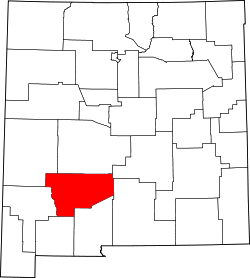
Engle
Location within the state of New Mexico
Usa edcp location map.svg
Red pog.svg
Engle
Engle (the United States)
Coordinates: 33°10′37″N107°01′53″W / 33.17694°N 107.03139°W / 33.17694; -107.03139
Country United States
State New Mexico
County Sierra
Elevation
[1]
4,777 ft (1,456 m)
Time zone UTC-7 (Mountain (MST))
  Summer (DST) UTC-6 (MDT)
ZIP code
87935
Area code 575
GNIS feature ID888887 [1]

Engle is an unincorporated community in Sierra County, New Mexico. [1]

Contents

Engle was a station on the Atchison, Topeka and Santa Fe Railway and New Mexico State Road 51 passes through the community. Elephant Butte Reservoir and Truth or Consequences lie to the west and the San Andres Mountains are to the east. [2]

History

El Camino Real de Tierra Adentro passed through the vicinity of Engle; two former segments of the road near Engle are listed on the National Register of Historic Places. [3] West of Engle is Engle Lake originally known as the Laguna del Muerto (Lake of the Dead Man). It was a paraje, one of the few along this route through the Jornada del Muerto with reliable seasonal water and grass that grew on the lake bottom following the retreating waters of the evaporating lake. If the lake was dry, stock had to be driven to water at the spring Ojo del Muerto, six miles west in the Fra Cristobal Range. [4] :155–157

Education

Truth or Consequences Municipal Schools is the school district for the entire county. [5] Truth or Consequences Middle School and Hot Springs High School, both in Truth or Consequences, are the district's secondary schools.

Notable person

Related Research Articles

<span class="mw-page-title-main">Sierra County, New Mexico</span> County in New Mexico, United States

Sierra County is a county located in the U.S. state of New Mexico. As of the 2020 Census, the population was 11,576. Its county seat is Truth or Consequences.

<span class="mw-page-title-main">Truth or Consequences, New Mexico</span> City in New Mexico, United States

Truth or Consequences is a city in the U.S. state of New Mexico, and the county seat of Sierra County. In 2020, the population was 6,052. It has frequently been noted on lists of unusual place names for having chosen to rename itself in March 1950 after the Truth or Consequences radio show. The name is often hyphenated for clarity, though the formal name contains no punctuation.

<span class="mw-page-title-main">Jornada del Muerto</span> Desert region in New Mexico, United States

Jornada del Muerto was the name given by the Spanish conquistadors to the Jornada del Muerto Desert basin, and the almost waterless 90-mile (140 km) trail across the Jornada beginning north of Las Cruces and ending south of Socorro, New Mexico. The name translates from Spanish as "Dead Man's Journey" or "Route of the Dead Man". The trail was part of the Camino Real de Tierra Adentro which led northward from central colonial New Spain, present-day Mexico, to the farthest reaches of the viceroyalty in northern Nuevo México Province.

<span class="mw-page-title-main">Elephant Butte Dam</span> Dam on the Rio Grande in New Mexico, United States

Elephant Butte Dam or Elephant Butte Dike, originally Engle Dam, is a concrete gravity dam on the Rio Grande near Truth or Consequences, New Mexico. The dam impounds Elephant Butte Reservoir, which is used mainly for agriculture but also provides for recreation, hydroelectricity, and flood and sediment control. The construction of the dam has reduced the flow of the Rio Grande to a small stream for most of the year, with water being released only during the summer irrigation season or during times of exceptionally heavy snow melt.

Arrey is a census-designated place in Sierra County, New Mexico, United States. It lies about 22 miles (35.4 km) south of Truth or Consequences. As of the 2010 census, its population was 232.

<span class="mw-page-title-main">Rio Grande Trail</span> Proposed trail in New Mexico, United States

The Rio Grande Trail is a proposed long distance trail along the Rio Grande in the U.S. state of New Mexico. The river extends over 1,800 total miles, some 700 miles (1,100 km) of which pass through the heart of New Mexico. It is the state's primary drainage feature and most valuable natural and cultural resource. The river and its bosque provide a wide variety of recreation, including hunting and fishing, birdwatching, river rafting, hiking, biking, and horseback riding. The river also flows through or beside numerous spectacular and geologically interesting landforms, the result of extensive volcanism and erosion of the valley within the Rio Grande Rift. Although some trail advocates would like to see the trail extended the full distance through New Mexico, from the Colorado border to the United States–Mexico border, the portion proposed for initial development extends 300 miles (480 km), from Bernalillo south to Las Cruces.

Point of Rocks may refer to:

Caballo is a census-designated place in Sierra County, New Mexico, United States. Its population was 112 as of the 2010 census. Caballo has a post office with ZIP code 87931. The community is located along New Mexico State Road 187, north and south of Exit 63 on Interstate 25.

<span class="mw-page-title-main">Winston, New Mexico</span> Census-designated place in New Mexico, United States

Winston is a census-designated place in Sierra County, New Mexico, United States. Its population was 61 as of the 2010 census. Winston has a post office with ZIP code 87943, which opened on August 15, 1881. The community was named for Frank Winston, a pioneer miner. New Mexico State Road 52 passes through the community.

Las Palomas is a census-designated place in Sierra County, New Mexico, United States. Its population was 173 as of the 2010 census. The community is located near Exit 71 of Interstate 25; New Mexico State Road 187 also passes through the community.

Oasis is a census-designated place in Sierra County, New Mexico, United States. Its population was 149 as of the 2010 census.

Derry is an unincorporated community located in Sierra County, New Mexico, United States. Derry is located on New Mexico State Road 187, 11.3 miles (18.2 km) northwest of Hatch. Derry has a post office with ZIP code 87933, which opened on August 11, 1911. The town was named after Derry, Ireland, which was suggested by a former soldier.

Monticello is an unincorporated community located in Sierra County, New Mexico, United States. Monticello is located on Alamosa Creek, 22 miles (35 km) northwest of Truth or Consequences. Monticello has a post office with ZIP code 87939.

Chloride is an unincorporated community in Sierra County, in the U.S. state of New Mexico. The community is located at the confluence of Chloride Creek with Mineral Creek. Most of the old mine workings are to the west, along Chloride Creek. Winston is approximately two miles to the east.

New Mexico State Road 27 (NM 27) is a 30.200-mile-long (48.602 km) paved, two-lane state highway in Sierra and Luna counties in the U.S. state of New Mexico. It travels south-to-north over the eastern flank of the Black Range.

Aleman is a locale, a formerly populated place in Sierra County, New Mexico, United States. It lies at an elevation of 4,669 feet.

Engle Lake, originally named Laguna del Muerto by the Spanish, is a seasonal lake in the Jornada del Muerto region in Sierra County, New Mexico. It lies at an elevation or 4,715 feet (1,437 m) in the depression in the Jornada Del Muerto basin.

The Camino Real in New Mexico was the northern part of a historic roadway known as the Camino Real de Tierra Adentro that from 1598 ran from Mexico City northward through central and northern Mexico and the Trans-Pecos part of what is now Texas to San Juan Pueblo in Santa Fe de Nuevo Mexico, now the state of New Mexico.

<span class="mw-page-title-main">Rio Grande Valley (New Mexico)</span> River valley of the Rio Grande in New Mexico, United States

The Rio Grande Valley is the river valley carved out by the Rio Grande as it flows through the American Southwest and northeastern Mexico, forming a part of the border region. In the US state of New Mexico, the river flows mostly north to south, and forms a valley near Cochiti Pueblo to the state line near El Paso, Texas along the floors of the large sedimentary basins of the Rio Grande Rift, and includes the narrow sections between the basins. It has been historically settled first by the Pueblo peoples, the Spanish, the Mexicans, and finally Anglo-Americans. As the largest river in the state, some of its most populous cities are located wholly or partially in the valley, including Albuquerque, New Mexico's largest city.

Hyde Park is an unincorporated community and census-designated place (CDP) in Santa Fe County, New Mexico, United States. It was first listed as a CDP prior to the 2020 census.

References

  1. 1 2 3 U.S. Geological Survey Geographic Names Information System: Engle, New Mexico
  2. Engle, NM and Sowell, NM 15 Minute Topographic Quadrangles, USGS, 1959
  3. "Weekly List of Actions Taken On Properties: 2/13/12 Through 2/17/12". National Park Service . Retrieved December 9, 2014.
  4. George D. Torok, From the Pass to the Pueblos, Sunstone Press, Santa Fe, Dec 1, 2011
  5. "2020 CENSUS - SCHOOL DISTRICT REFERENCE MAP: Sierra County, NM" (PDF). U.S. Census Bureau . Retrieved July 12, 2022. - Text list
  6. IMDb-Rudd Weatherwax

Commons-logo.svg Media related to Engle, New Mexico at Wikimedia Commons