Las Palomas, New Mexico

Last updated

Las Palomas, New Mexico
Census-designated place
USA New Mexico location map.svg
Red pog.svg
Las Palomas, New Mexico
Coordinates: 33°03′32″N107°17′54″W / 33.05889°N 107.29833°W / 33.05889; -107.29833
CountryUnited States
State New Mexico
County Sierra
Area
[1]
  Total1.60 sq mi (4.15 km2)
  Land1.60 sq mi (4.15 km2)
  Water0.00 sq mi (0.00 km2)
Elevation
[2]
4,262 ft (1,299 m)
Population
 (2020) [3]
  Total196
  Density122.27/sq mi (47.21/km2)
Time zone UTC−7 (Mountain (MST))
  Summer (DST) UTC−6 (MDT)
Area code 575
GNIS feature ID2584135 [2]

Las Palomas is a census-designated place in Sierra County, New Mexico, United States. Its population was 173 as of the 2010 census. [4] The community is located near Exit 71 of Interstate 25; New Mexico State Road 187 also passes through the community.

Contents

History

Las Palomas was one of the offspring settlements of San Ygnacio de la Alamosa, also known as Alamosa, the original native New Mexican settlement, in what became Sierra County, in 1859. After flooding destroyed Alamosa in 1867, many of its residents moved up the Alamosa Creek valley to farm near and live in the new town, called Canada Alamosa. That town had been organized by some earlier residents of Alamosa sometime between 1864 and 1866. [5] :33–46

Others moved across the river to the east bank and downstream a couple of miles to farm on the opposite side of the river and to start a new town, first called New Alamosa, but that soon became known as Alamocita. Alamocita was six miles north of Fort McRae which was established in April 1863 to protect these new settlements along the Rio Grande Valley from the Apache, along with the traffic along the river and the old road to the east in the Jornada del Muerto. [5] :42–48,54–56,60,73–76

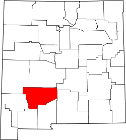
Also in 1867, a number of the citizens of Canada Alamosa, moved down the Rio Grande to where Palomas Creek had its confluence with the river. There twenty miles south of Fort McRae, it was less exposed to the attacks of the Apache, and easier to reinforce from the fort. There they established the farming settlement first called Plaza del Rio Palomas, later more commonly called Las Palomas. Fort McRae and its garrison would provide its protection and economic benefits to citizens of the towns over the years of its operation until it was closed on October 30, 1876. Las Palomas is the only one of the early New Mexican settlements built along the Rio Grande in Sierra County to survive to the present day despite the river flooding and the construction of reservoirs. [5] :42–48,54–56,60,73–76

Geography

According to the U.S. Census Bureau, the community has an area of 1.599 square miles (4.14 km2), all land. [4]

Demographics

Historical population
CensusPop.Note
2020 196
U.S. Decennial Census [6] [3]

Education

Truth or Consequences Municipal Schools is the school district for the entire county. [7] Truth or Consequences Middle School and Hot Springs High School, both in Truth or Consequences, are the district's secondary schools.

Related Research Articles

<span class="mw-page-title-main">Kinney County, Texas</span> County in Texas, United States

Kinney County is a county located in the U.S. state of Texas. As of the 2020 census, its population was 3,129. Its county seat is Brackettville. The county was created in 1850 and later organized in 1874. It is named for Henry Lawrence Kinney, an early settler.

<span class="mw-page-title-main">Sierra County, New Mexico</span> County in New Mexico, United States

Sierra County is a county located in the U.S. state of New Mexico. As of the 2020 Census, the population was 11,576. Its county seat is Truth or Consequences.

<span class="mw-page-title-main">Manassa, Colorado</span> Town in Colorado, United States

Founded in 1851, the Town of Manassa is a Statutory Town and is the most populous municipality in Conejos County, Colorado, United States. The town's population was 947 at the 2020 United States Census.

<span class="mw-page-title-main">Elephant Butte, New Mexico</span> City in Sierra County, New Mexico, United States

Elephant Butte is a city in Sierra County, New Mexico, United States, located near Elephant Butte Reservoir and Elephant Butte Lake State Park. The population was 1,431 at the time of the 2010 census.

<span class="mw-page-title-main">Truth or Consequences, New Mexico</span> City in New Mexico, United States

Truth or Consequences is a city in the U.S. state of New Mexico, and the county seat of Sierra County. In 2020, the population was 6,052. It has frequently been noted on lists of unusual place names for having chosen to rename itself in March 1950 after the Truth or Consequences radio show. The name is often hyphenated for clarity, though the formal name contains no punctuation.

<span class="mw-page-title-main">Socorro, New Mexico</span> City in New Mexico, United States

Socorro is a city in Socorro County in the U.S. state of New Mexico. It is in the Rio Grande Valley at an elevation of 4,579 feet (1,396 m). In 2010 the population was 9,051. It is the county seat of Socorro County. Socorro is located 74 miles (119 km) south of Albuquerque and 146 miles (235 km) north of Las Cruces.

<span class="mw-page-title-main">Presidio, Texas</span> City in Texas, United States

Presidio is a city in Presidio County, Texas, United States. It is situated on the Rio Grande River, on the opposite side of the U.S.–Mexico border from Ojinaga, Chihuahua. The name originates from Spanish and means "fortress". The population was 4,169 at the 2000 census, and had increased to 4,426 as of the 2010 US census.

<span class="mw-page-title-main">Jornada del Muerto</span> Desert region in New Mexico, United States

Jornada del Muerto was the name given by the Spanish conquistadors to the Jornada del Muerto Desert basin, and the almost waterless 90-mile (140 km) trail across the Jornada beginning north of Las Cruces and ending south of Socorro, New Mexico. The name translates from Spanish as "Dead Man's Journey" or "Route of the Dead Man". The trail was part of the Camino Real de Tierra Adentro which led northward from central colonial New Spain, present-day Mexico, to the farthest reaches of the viceroyalty in northern Nuevo México Province.

<span class="mw-page-title-main">Fort Craig</span> United States historic place in New Mexico

Fort Craig was a U.S. Army fort located along El Camino Real de Tierra Adentro, near Elephant Butte Lake State Park and the Rio Grande in Socorro County, New Mexico.

Polvadera is an unincorporated community and census-designated place in Socorro County in central New Mexico, United States. It is located on the west bank of the Rio Grande, near the mouth of the Rio Salado, and on the western spur of El Camino Real de Tierra Adentro.

<span class="mw-page-title-main">Battle of Canada Alamosa</span> Part of the American Civil War in New Mexico Territory (1861)

The Battle of Canada Alamosa as it was known to the Union Army, or Alamosa as it was known to the Confederates, was a skirmish of the American Civil War on the late evening of September 24 and the morning of September 25, 1861. It was one of several small battles that occurred in Confederate Arizona near the border with Union held New Mexico Territory, this one being the largest.

Canada Alamosa an Americanized version of the Spanish Cañada Alamosa, is a term historically applied to five geographical features, all in the same immediate area in southwest Socorro and northwest Sierra Counties, New Mexico. In historical texts the name, Canada Alamosa is applied inter-changeably to the five features, and it is often only the context that distinguishes one feature from the other.

Monticello is an unincorporated community located in Sierra County, New Mexico, United States. Monticello is located on Alamosa Creek, 22 miles (35 km) northwest of Truth or Consequences. Monticello has a post office with ZIP code 87939.

Hispanic and Latino Coloradans are residents of the state of Colorado who are of Hispanic or Latino ancestry. As of 2020, Hispanics and Latinos of any race made up 21% of the state's population, or 1,269,520 of the state's 5,770,545 residents.

<span class="mw-page-title-main">Cuchillo, New Mexico</span> Unincorporated community in New Mexico, US

Cuchillo, originally known as Cuchillo Negro, is an unincorporated community in Sierra County, New Mexico, United States. It was named for Apache chieftain Baishan, known by his Spanish name Cuchillo Negro "Black Knife", who was killed in a skirmish with American troops in 1857. The town is located on the north bank of Cuchillo Negro Creek. Cuchillo's name change came after the 1900 Census. It was recorded under its present name in the 1910 Census.

Cañon del Muerto is a canyon, in Sierra County, New Mexico.

Fort McRae was a Union Army post, established in 1863, then a U.S. Army post from 1866 and closed in 1876, in what is now Sierra County, New Mexico. The post was named for Alexander McRae (1829–1862) a slain hero of the 1862 Battle of Valverde.

San Ygnacio de la Alamosa, also known as Alamosa, is now a ghost town, in Sierra County, New Mexico, United States. San Ygnacio de la Alamosa was founded in 1859 as a native New Mexican colonizing settlement from San Antonio. The site of the new colony was along the west bank of the Rio Grande, 35 miles south of Fort Craig, on the south bank of Alamosa Creek nearby its mouth and confluence with the Rio Grande, in what was then southern Socorro County.

Alamocita, initially called New Alamosa, was a later 19th century native New Mexican frontier settlement along the east bank of the Rio Grande and is now a ghost town in Sierra County, New Mexico, United States.

Zapata, sometimes called Zapato, or San Ignacio is a ghost town in Sierra County, New Mexico, United States. Its site was submerged by the Elephant Butte Reservoir some years after it had been abandoned.

References

  1. "ArcGIS REST Services Directory". United States Census Bureau. Retrieved October 12, 2022.
  2. 1 2 U.S. Geological Survey Geographic Names Information System: Las Palomas, New Mexico
  3. 1 2 "Census Population API". United States Census Bureau. Retrieved October 12, 2022.
  4. 1 2 "2010 Census Gazetteer Files - Places: New Mexico". U.S. Census Bureau. Archived from the original on July 14, 2014. Retrieved August 21, 2014.
  5. 1 2 3 Wilson, John P., Between the River and the Mountains: A History of Early Settlement in Sierra County, New Mexico, Report #40, John P. Wilson, Las Cruces, New Mexico, August 1985 [ permanent dead link ]
  6. "Census of Population and Housing". Census.gov. Retrieved June 4, 2016.
  7. "2020 CENSUS - SCHOOL DISTRICT REFERENCE MAP: Sierra County, NM" (PDF). U.S. Census Bureau . Retrieved July 12, 2022. - Text list